Engeløya

Last updated
Engeløya
Napoleonsprofilen.JPG
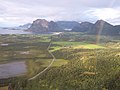
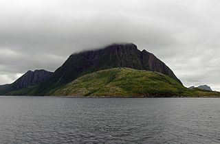
The western mountains of Engeløya, known as "Napoleons profile"
Norway - Engeloya.png
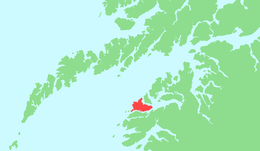
Location in Nordland
Geography
Location Nordland, Norway
Coordinates 67°57′N15°05′E / 67.950°N 15.083°E / 67.950; 15.083 Coordinates: 67°57′N15°05′E / 67.950°N 15.083°E / 67.950; 15.083
Area69 km2 (27 sq mi)
Highest elevation649 m (2,129 ft)
Highest pointTrohornet
Administration
County Nordland
Municipality Steigen

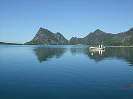
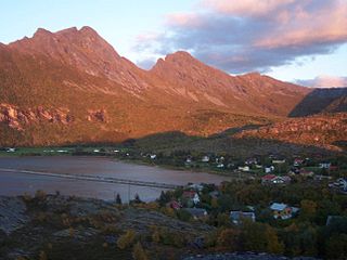
Engeløya is an island in the northern part of the municipality of Steigen in Nordland county, Norway. The island has an area of 69 square kilometres (27 sq mi). The highest point on the island is the 649-metre (2,129 ft) Trohornet mountain. The rocky, mountainous island has grassy slopes that are fertile and it has some of the better farmland in the municipality. [1]

Island Any piece of sub-continental land that is surrounded by water

An island or isle is any piece of sub-continental land that is surrounded by water. Very small islands such as emergent land features on atolls can be called islets, skerries, cays or keys. An island in a river or a lake island may be called an eyot or ait, and a small island off the coast may be called a holm. A grouping of geographically or geologically related islands is called an archipelago, such as the Philippines.

Steigen Municipality in Nordland, Norway

Steigen is a municipality in Nordland county, Norway. It is part of the traditional district of Salten. The administrative centre of the municipality is the village of Leinesfjord. Other villages include Bogen, Leines, Nordfold, Nordskot, and Sørskot. Engeløy Airport, Grådussan is located in the northern part of the municipality. Måløy–Skarholmen Lighthouse is located in the Vestfjorden in the western part of the municipality. The only road access to the municipality is via the Steigen Tunnel.

Nordland County (fylke) of Norway

Nordland is a county in Norway in the Northern Norway region, bordering Troms in the north, Trøndelag in the south, Norrbotten County in Sweden to the east, Västerbotten County to the southeast, and the Atlantic Ocean to the west. The county was formerly known as Nordlandene amt. The county administration is in Bodø. The remote Arctic island of Jan Mayen has been administered from Nordland since 1995.

Contents

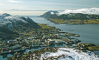
Engeløya is connected to the mainland by the Engeløy Bridges. The Engeløy Airport, Grådussan is located on the northwestern tip of the island. Steigen Church is located on the southwestern side of the island. [1]

Engeløy Bridges bridge in Steigen, Norway

The Engeløy Bridges are two bridges in the municipality of Steigen in Nordland county, Norway. The bridges were built in 1978 to connect the island of Engeløya to the mainland.

Engeløy Airport, Grådussan airport in Steigen, Norway

Engeløy Airport, Grådussan is an airport located on the northwest tip of Engeløya, an island in Steigen municipality, Nordland county, Norway.

Steigen Church Church in Nordland, Norway

Steigen Church is a parish church of the Church of Norway in Steigen Municipality in Nordland county, Norway. It is located in the small village of Steigen on the southwestern side of the island of Engeløya. It is the main church for the Steigen parish which is part of the Salten prosti (deanery) in the Diocese of Sør-Hålogaland. The brown and gray, stone church was originally built in a long church style around the year 1250, and it has since been renovated and expanded several times. The church seats about 400 people.

The name Engeløya translates as "Angel Island" in English.

English language West Germanic language

English is a West Germanic language that was first spoken in early medieval England and eventually became a global lingua franca. It is named after the Angles, one of the Germanic tribes that migrated to the area of Great Britain that later took their name, as England. Both names derive from Anglia, a peninsula in the Baltic Sea. The language is closely related to Frisian and Low Saxon, and its vocabulary has been significantly influenced by other Germanic languages, particularly Norse, and to a greater extent by Latin and French.

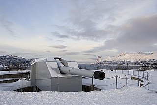
During WWII, the German Battery Dietl was constructed with three 40.6 cm SK C/34 guns as part of the Atlantic Wall. [2]

40.6 cm SK C/34 gun

The 40.6 cm SK C/34, sometimes known as the Adolfkanone, was a German naval gun, designed in 1934 by Krupp and originally intended for the early H-class battleships.

The Atlantic Wall was an extensive system of coastal defence and fortifications built by Nazi Germany between 1942 and 1944, along the coast of continental Europe and Scandinavia as a defence against an anticipated Allied invasion of Nazi-occupied Europe from the United Kingdom, during World War II. The manning and operation of the Atlantic Wall was administratively overseen by the German Army, with some support from Luftwaffe ground forces. The Kriegsmarine maintained a separate coastal defence network, organised into a number of sea defence zones.

See also

Trondenes Fort

Trondenes Fort is a fort situated on the Trondenes peninsula in the municipality of Harstad in Troms county, Norway. It is located about 2.5 kilometres (1.6 mi) north of the town of Harstad. The fort has been the main base for the Norwegian Coastal Ranger Command since 2002. The fort was built in 1943 by the Nazis occupying Norway during World War II as a part of the Atlantic Wall.

Related Research Articles

Herøy, Møre og Romsdal Municipality in Møre og Romsdal, Norway

Herøy is a municipality in Møre og Romsdal county, Norway. It is part of the Sunnmøre region. The administrative centre is the town of Fosnavåg on the island of Bergsøya. The industrial area of Eggesbønes is located south of Fosnavåg on the same island. The Runde Environmental Centre is located in the northern part of the municipality on Runde island. Other population centres in Herøy include the villages of Leikong, Kvalsund, or Moltustranda.

Hamarøy Municipality in Nordland, Norway

Hamarøy (Norwegian) or Hábmer (Lule Sami) is a municipality in Nordland county, Norway. It is part of the traditional district of Salten. The administrative centre of the municipality is the village of Oppeid. Other villages include Innhavet, Karlsøy, Presteid, Skutvika, Tømmerneset, Tranøy, and Ulvsvåg.

Hammerfest Municipality in Finnmark, Norway

Hammerfest is a municipality in Finnmark county, Norway. The administrative centre of the municipality is the town of Hammerfest. Some of the main villages in the municipality include Rypefjord, Forsøl, Hønsebybotn, Akkarfjord i Kvaløya, Akkarfjord i Sørøya, and Kårhamn.

Prestegårdsskogen Nature Reserve nature reserve in Norway

Prestegårdsskogen Nature Reserve is a nature reserve on the southern side of the island of Engeløya in the municipality of Steigen in Nordland county, Norway. It is a heavily hazel-forested area; other than a few far smaller exceptions, it is the northernmost known hazel forest. Various other species find their northernmost extent here.

Forsanvatnet lake in Nordland, Norway

Forsanvatnet or Forsvatnet is a lake that lies on the border of the municipalities of Steigen and Hamarøy in Nordland county, Norway. The 4.83-square-kilometre (1.86 sq mi) lake lies just south of the Steigen Tunnel in the northeast part of Steigen.

Leiranger Former municipality in Nordland, Norway

Leiranger is a former municipality in Nordland county, Norway. The 185-square-kilometre (71 sq mi) municipality existed from 1900 until its dissolution in 1964. The municipality was encompassed the around the Leinesfjorden and the islands surrounding the mouth of the fjord in what is now Steigen Municipality. The administrative centre of Leiranger was the village of Leines. The village of Leinesfjorden lies at the end of the fjord.

Bogen, Steigen Village in Northern Norway, Norway

Leirvikbogen or simply Bogen is a village in the municipality of Steigen in Nordland county, Norway. It is located about 15 kilometres (9.3 mi) northeast of the municipal centre of Leinesfjorden. The Engeløy Bridges connect Bogen to the nearby island of Engeløya to the north. Bogen and its surrounding villages have a total of about 210 residents (2016). Bogen Chapel is located in the village.

Bogen Chapel (Steigen) Church in Nordland, Norway

Bogen Chapel is a chapel of the Church of Norway in Steigen Municipality in Nordland county, Norway. It is located in the village of Bogen. It is an annex chapel in the Steigen parish which is part of the Salten prosti (deanery) in the Diocese of Sør-Hålogaland. The white, wooden chapel was built in a long church style in 1926 by the architect Sverre Kristiansen. In 1945, the chapel was temporarily occupied by the invading German army and used as a barracks for several months. During the 1970s, the chapel was extensively remodeled and restored.

Odderøya

Odderøya is an island in Kristiansand municipality in Vest-Agder county, Norway. The 0.7-square-kilometre (170-acre) island lies immediately to the south of the city centre of Kristiansand and it is connected to the mainland by four bridges. The island creates a natural division between the eastern and western parts of the port of Kristiansand.

Salten District Court district court in Salten, Norway

Salten District Court is a district court located in the town of Bodø in Nordland county, Norway. The court serves the Salten district in the central part of the county as well as two outlying island municipalities. It includes the municipalities of Beiarn, Bodø, Fauske, Gildeskål, Meløy, Saltdal, Steigen, Sørfold, Værøy, and Røst. It also holds jurisdiction over the outlying territory of Jan Mayen. The court is subordinate to the Hålogaland Court of Appeal. The court is led by the chief judge Ingrid Johanne Lillevik. This court employs a chief judge, four other judges, and four prosecutors.

Nordfold (municipality) Former municipality in Nordland, Norway

Nordfold is a former municipality in Nordland county, Norway. The 561-square-kilometre (217 sq mi) municipality existed from 1906 until its dissolution in 1964. The municipality surrounded the Nordfolda branch off of the Folda fjord in what is now Steigen Municipality, plus a small portion of the present-day Sørfold Municipality. The administrative centre of the municipality was the village of Nordfold, where the Nordfold Church is located.

Kjerringøy (municipality) Former municipality in Nordland, Norway

Kjerringøy is a former municipality in Nordland county, Norway. The 176-square-kilometre (68 sq mi) municipality existed from 1906 until its dissolution in 1964. The municipality included the coastal and island areas around the entrance to the Folda fjord, plus the northern coast of the Mistfjorden to the south of the Folda fjord. About 400 small islands totaling about 11 square kilometres (4.2 sq mi) were part of the municipality. The areas are located in what is now Bodø Municipality and a small part in Steigen Municipality. The administrative centre of the municipality was the village of Kjerringøy where Kjerringøy Church is located.

Lundøya

Lundøya is an island in Steigen Municipality in Nordland county, Norway. The island lies at the entrance to the Sagfjorden between the island of Engeløya in Steigen and the village of Skutvika on the mainland in Hamarøy Municipality. The island has an area of 26.46 square kilometres (10.22 sq mi) and its highest point is the 803-metre (2,635 ft) tall mountain Lundtinden. Lundøya is now uninhabited, but has previously had settlements on it until the 1970s.

References

  1. 1 2 Store norske leksikon. "Engeløya" (in Norwegian). Retrieved 2012-04-23.
  2. "German Gun Battery Dietl, located on Engeløya".