Last updated Historical marker in the Manatee Village Historical Park in Bradenton, at the western end of the Trail
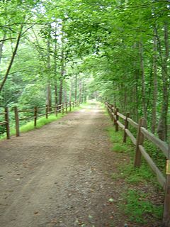
The Florida Cracker Trail runs from just east of Bradenton, and ends in Fort Pierce, a total distance of approximately 120 miles (190km).
Florida crackers were colonial-era Ireland/ Celtic and American pioneer settlers and their descendants in what is now the U.S. state of Florida. The first of these arrived in 1763 after Spain traded Florida to Great Britain following the latter's victory over France in the Seven Years' War.
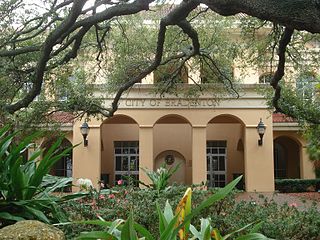
Bradenton is a city in Manatee County, Florida, United States. The U.S. Census Bureau estimated the city's 2016 population to be 54,437. Bradenton is a principal city of the North Port–Sarasota–Bradenton metropolitan statistical area, which had a 2017 estimated population of 702,281. It is the county seat.
Fort Pierce is a city in and the county seat of St. Lucie County, Florida, United States. The city is part of the Treasure Coast region of Atlantic Coast Florida. It is also known as the Sunrise City, sister to San Francisco, California, the Sunset City. The population was 41,590 at the 2010 census. As of 2012, the population recorded by the U.S. Census Bureau was 42,645. It was named after the Fort Pierce Army post which was built nearby in 1838 during the Second Seminole War. The military post had been named for Benjamin Kendrick Pierce, a career United States Army officer and the brother of President Franklin Pierce.
On November 20, 2000, the Florida Cracker Trail was selected as a Community Millennium Trail. The Millennium Trails is a partnership among the White House Millennium Council, the Department of Transportation, Rails-to-Trails Conservancy, the National Endowment for the Arts and other public agencies and private organizations. The goal of Millennium Trails is the creation of a nationwide network of trails that protect natural environment, interpret history and culture, and enhance alternative transportation, recreation and tourism.
The White House Millennium Council was an American organization established by Executive Order 13072 in 1998 by President Bill Clinton as part of global millennium celebrations. The council's theme was "Honor the Past – Imagine the Future."
Rails-to-Trails Conservancy (RTC) is an American nonprofit organization based in Washington, D.C. that works with communities to preserve unused rail corridors by transforming them into rail trails within the United States of America. RTC's purpose is to create a nationwide network of trails from former rail lines and connecting corridors.
The National Endowment for the Arts (NEA) is an independent agency of the United States federal government that offers support and funding for projects exhibiting artistic excellence. It was created by an act of the U.S. Congress in 1965 as an independent agency of the federal government. The NEA has its offices in Washington, D.C. It was awarded Tony Honors for Excellence in Theatre in 1995, as well as the Special Tony Award in 2016.
An annual Cracker Trail ride is now held the last full week in February of each year. The ride begins at a site just east of Bradenton, Florida, and ends with a parade through downtown Ft. Pierce, Florida, a total of approximately 120 miles (190km). Each day's ride is approximately 15 to 20 miles in length. The purpose of the ride is to draw attention to Florida's horse and cattle heritage.
A geographic coordinate system is a coordinate system that enables every location on Earth to be specified by a set of numbers, letters or symbols. The coordinates are often chosen such that one of the numbers represents a vertical position and two or three of the numbers represent a horizontal position; alternatively, a geographic position may be expressed in a combined three-dimensional Cartesian vector. A common choice of coordinates is latitude, longitude and elevation. To specify a location on a plane requires a map projection.
This page is based on this Wikipedia article Text is available under the CC BY-SA 4.0 license; additional terms may apply. Images, videos and audio are available under their respective licenses.
Related Research Articles
Arcadia is a city and county seat of DeSoto County, Florida, United States. The population was 7,637 as of the 2010 census, with an estimated population of 7,722 in 2014. Arcadia's Historic District is listed on the National Register of Historic Places.
Zolfo Springs is a town in Hardee County, Florida, United States. The population was 1,827 at the 2010 census, up from 1,641 at the 2000 census.
Sebring is a city in Highlands County, Florida, United States, nicknamed "The City on the Circle", in reference to Circle Drive, the center of the Sebring Downtown Historic District. As of the 2010 census the population was 10,491. It is the county seat of Highlands County, and is the principal city of the Sebring Metropolitan Statistical Area.
The East Coast Greenway is a 3,000-mile (4,800 km) biking and walking route linking the major cities of the Atlantic coast of the United States, from Calais, Maine, to Key West, Florida. The spine route and branching complementary routes are for non-motorized human transportation for everything from local commutes to long-distance trips.
U.S. Route 11 is a signed north–south highway United States highway extending 1,645 miles (2,647 km) across the eastern United States. The southern terminus of the route is at U.S. Route 90 in the Bayou Sauvage National Wildlife Refuge in eastern New Orleans, Louisiana. The northern terminus is at the Rouses Point - Lacolle 223 Border Crossing in Rouses Point, New York. The route continues across the border into Canada as Quebec Route 223. US 11, created in 1926, largely follows the route of the original plan.
Florida's Turnpike, designated as unsigned State Road 91, is a toll road in the U.S. state of Florida, maintained by Florida's Turnpike Enterprise (FTE). Spanning approximately 309 miles (497 km) along a north–south axis, the turnpike is in two sections. The SR 91 mainline runs roughly 265 miles (426 km), from its southern terminus at an interchange with Interstate 95 (I-95) in Miami Gardens to an interchange with I-75 in Wildwood at its northern terminus. The Homestead Extension of Florida's Turnpike continues from the southern end of the mainline for another 48 miles (77 km) to US Highway 1 in Florida City. The slogan for the road is "The Less Stressway".
The Burke-Gilman Trail is a rail trail in King County, Washington. The 27-mile (43 km) multi-use recreational trail is part of the King County Regional Trail System and occupies an abandoned Seattle, Lake Shore and Eastern Railway corridor.
The Cady Way Trail is a 6.5-mile (10.5 km) rail trail in the Orlando, Florida area opened in 1994. It is partly owned by the Orlando Department of Families, Parks and Recreation and partly by Orange County Parks and Recreation. The project was awarded a $1,750,000 Transportation Enhancement grant by the Federal Highway Administration and the Florida Department of Transportation, and a $483,000 grant from the Florida Department of Environmental Protection.
The West Orange Trail is a 22-mile (35 km) long multi-use rail trail owned by Orange County Parks and Recreation in Orange County, Florida, in the United States. The paved trail passes through downtown Oakland, Winter Garden, and Apopka with most of its length built on old railroad alignments. To the west of the West Orange Trail is the South Lake-Lake Minneola Scenic Trail in Lake County which was connected to the trail in 2007.
The Ocala National Forest ls the second largest nationally protected forest in the U.S. State of Florida. It covers 607 square miles (1,570 km2) of Central Florida. It is located three miles (5 km) east of Ocala and 16 miles (26 km) southeast of Gainesville. The Ocala National Forest, established in 1908, is the oldest national forest east of the Mississippi River and the southernmost national forest in the continental U.S. The word Ocala is thought to be a derivative of a Timucuan term meaning "fair land" or "big hammock". The forest is headquartered in Tallahassee, as are all three National Forests in Florida, but there are local ranger district offices located in Silver Springs and Umatilla.
The Barlow Road is a historic road in what is now the U.S. state of Oregon. It was built in 1846 by Sam Barlow and Philip Foster, with authorization of the Provisional Legislature of Oregon, and served as the last overland segment of the Oregon Trail. Its construction allowed covered wagons to cross the Cascade Range and reach the Willamette Valley, which had previously been nearly impossible. Even so, it was by far the most harrowing 100 miles (160 km) of the nearly 2,000-mile (3,200 km) Oregon Trail.
The Saint Johns River Ferry, also known as the Mayport Ferry, is an automobile ferry between Mayport and Fort George Island, two areas within Jacksonville, Florida. The 0.9 miles (1.4 km) voyage crosses the Saint Johns River about 2.5 miles (4.0 km) inland of the river's mouth and travels in an east-west direction for approximately 2,000 feet (610 m) on State Road A1A. It departs every half-hour.
Lake Kissimmee State Park is a 5,930-acre (24 km²) Florida State Park located north of State Road 60, 15 miles (24 km) east of Lake Wales. It contains floodplain, forest, prairie, hammock, flatwoods and Lakes Kissimmee, Tiger, and Rosalie. The park is home to 50 species of plants and animals that are either threatened, of special concern or endangered.
Interstate 95 (I-95) is the main Interstate Highway of Florida's Atlantic Coast. It begins at a partial interchange with U.S. Highway 1 (US 1) just south of downtown Miami, and heads north past Daytona Beach, through Jacksonville, and to the Georgia state line at the St. Marys River near Becker. The route also passes through the cities of Fort Lauderdale, West Palm Beach, and Titusville.
Known for beautiful beaches, nature preserves and parks, Hutchinson Island consists of two barrier islands on the coast of Martin, St. Lucie, and Indian River counties, Florida. The two islands are separated by the Fort Pierce Inlet and are known as North Hutchinson Island and South Hutchinson Island. North Hutchinson Island is divided into two counties - Indian River County and St. Lucie County. The Indian River county portion of North Hutchinson Island which extends to the Sebastian Inlet is sometimes called Orchid Island, although it is not a separate island. See the Wikipage for North Hutchinson Island for more information.
The Cross Seminole Trail is a pedestrian, bicycle, and equestrian trail in Seminole County, Florida just north of Orlando. The first segment opened in 2002. The current route begins in Oviedo and stretches into Winter Springs. An overpass was constructed in 2012, where the trail crosses State Road 434. The trail is 23 miles (37 km) long, or 34 miles (55 km) including the Orange County trail extension. Plans include extending the trail into Heathrow, in Lake Mary.
The Jacksonville-Baldwin Rail Trail is a Rail Trail that extends from northwest Jacksonville to Baldwin, Florida. While it is technically a city park, it includes three separate paths: a multi-use asphalt trail for hiking, jogging, in-line skating or cycling; an off-road bike trail; and a horseback riding trail.
Sun Ray, Florida, is an unincorporated community in south Polk County, Florida. Its area is almost entirely land; the total water area is less than 0.01 square miles (0.026 km2) and most of that area is septic ponds on the south edge of Sun Ray. Approximately 90% of the community is on the east side of U.S. Highway 27. A railroad line runs diagonally south to north along the southwest boundary of Sun Ray. Sun Ray measures 0.77 miles (1.24 km) at its longest point and 0.22 miles (0.35 km) at its widest point.