Forked Deer River

Last updated
Forked Deer River

South Fork Forked Deer River.jpg

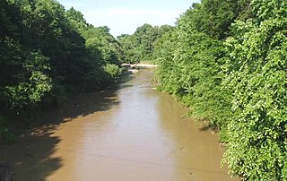
The South Fork of the Forked Deer River near Halls, Tennessee
Country United States
States Tennessee
Physical characteristics
Main source 230 ft (70 m)
River mouth Obion River, Mississippi River
The South Fork of the Forked Deer River at Jackson, Tennessee S Fk Forked Deer River.jpg
The South Fork of the Forked Deer River at Jackson, Tennessee

The Forked Deer River system is the main drainage of the central portion of West Tennessee. Locals pronounce the first word of the river's name with two syllables, as in “Forkéd” ( /ˈfɔːrkɪd/ ).

Drainage natural or artificial removal of surface and sub-surface water from an area

Drainage is the natural or artificial removal of a surface's water and sub-surface water from an area with excess of water. The internal drainage of most agricultural soils is good enough to prevent severe waterlogging, but many soils need artificial drainage to improve production or to manage water supplies.

West Tennessee is one of the three Grand Divisions of the state of Tennessee. Of the three, it is the one that is most sharply defined geographically. Its boundaries are the Mississippi River on the west and the Tennessee River on the east. This region's boundaries have been expanded slightly to include all of Hardin County, which is bisected by the Tennessee River. The states of Kentucky and Mississippi provide the respective northern and southern boundaries, with the exception of a portion of Lauderdale County, Alabama, which lies southeast of Hardin County. The region consists of twenty-one counties.

Contents

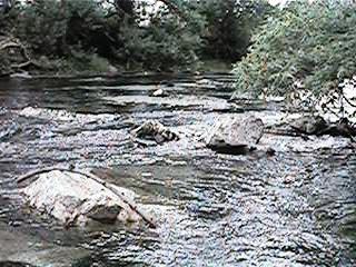
The Forked Deer consists of various streams designated "Forked Deer" and their tributaries. Much of the Forked Deer drainage basin was initially wetlands; however much of this area has been drained and most Forked Deer tributaries have been channelized for agricultural purposes. In the mid-20th century much of this was done under the auspices of the Obion-Forked Deer Basin Authority, a Tennessee state agency. Environmental concerns have led to the cessation of channelization on a widespread basis; the federal government's "no net loss" policy regarding wetlands means that further channelization must be offset by creating new wetlands, called "mitigation lands", elsewhere.

Drainage basin Area of land where precipitation collects and drains off into a common outlet

A drainage basin is any area of land where precipitation collects and drains off into a common outlet, such as into a river, bay, or other body of water. The drainage basin includes all the surface water from rain runoff, snowmelt, and nearby streams that run downslope towards the shared outlet, as well as the groundwater underneath the earth's surface. Drainage basins connect into other drainage basins at lower elevations in a hierarchical pattern, with smaller sub-drainage basins, which in turn drain into another common outlet.

Wetland A land area that is permanently or seasonally saturated with water

A wetland is a distinct ecosystem that is inundated by water, either permanently or seasonally, where oxygen-free processes prevail. The primary factor that distinguishes wetlands from other land forms or water bodies is the characteristic vegetation of aquatic plants, adapted to the unique hydric soil. Wetlands play a number of functions, including water purification, water storage, processing of carbon and other nutrients, stabilization of shorelines, and support of plants and animals. Wetlands are also considered the most biologically diverse of all ecosystems, serving as home to a wide range of plant and animal life. Whether any individual wetland performs these functions, and the degree to which it performs them, depends on characteristics of that wetland and the lands and waters near it. Methods for rapidly assessing these functions, wetland ecological health, and general wetland condition have been developed in many regions and have contributed to wetland conservation partly by raising public awareness of the functions and the ecosystem services some wetlands provide.

Agriculture Cultivation of plants and animals to provide useful products

Agriculture is the science and art of cultivating plants and livestock. Agriculture was the key development in the rise of sedentary human civilization, whereby farming of domesticated species created food surpluses that enabled people to live in cities. The history of agriculture began thousands of years ago. After gathering wild grains beginning at least 105,000 years ago, nascent farmers began to plant them around 11,500 years ago. Pigs, sheep and cattle were domesticated over 10,000 years ago. Plants were independently cultivated in at least 11 regions of the world. Industrial agriculture based on large-scale monoculture in the twentieth century came to dominate agricultural output, though about 2 billion people still depended on subsistence agriculture into the twenty-first.

Much of the channelized flow is routed into the Obion River just above the mouth of that river into the Mississippi, other streams related to the system have their own mouths into the Mississippi. In some areas where the historic channels are left in place even after the bulk of the flow has been routed into new ones, the historic channels at times still demonstrate considerable flow, especially after heavy rains.

Obion River river in the United States of America

The Obion River system is the primary surface water drainage system of northwestern Tennessee.

Mississippi River largest river system in North America

The Mississippi River is the second-longest river and chief river of the second-largest drainage system on the North American continent, second only to the Hudson Bay drainage system. Its source is Lake Itasca in northern Minnesota and it flows generally south for 2,320 miles (3,730 km) to the Mississippi River Delta in the Gulf of Mexico. With its many tributaries, the Mississippi's watershed drains all or parts of 32 U.S. states and two Canadian provinces between the Rocky and Appalachian mountains. The main stem is entirely within the United States; the total drainage basin is 1,151,000 sq mi (2,980,000 km2), of which only about one percent is in Canada. The Mississippi ranks as the fourth-longest and fifteenth-largest river by discharge in the world. The river either borders or passes through the states of Minnesota, Wisconsin, Iowa, Illinois, Missouri, Kentucky, Tennessee, Arkansas, Mississippi, and Louisiana.

Local historians record that barges and small riverboats plied the Forked Deer in the early 19th century as far up river as the present location of the city of Jackson. Siltation from agricultural run-off eventually choked the river, and channelization became a major focus of West Tennessee politicians until the 1970s. River cutoffs have left numerous small finger lakes that are popular with local crappie and bass fishers. Otherwise, the river is a slow-moving canal with little scenic appeal.

Crappie genus of fishes

Crappies are a genus, Pomoxis, of North American fresh water fish in the sunfish family Centrarchidae. Both species in this genus are popular pan fish.

Bass is a name shared by many species of fish. The term encompasses both freshwater and marine species, all belonging to the large order Perciformes, or perch-like fishes. The word bass comes from Middle English bars, meaning "perch".

Forked Deer River Tributaries

The North Fork of the Forked Deer River is formed in Gibson County to the south of Chapel Hill Road near Medina and flows to the northwest before entering Dyer County. Here it accepts the flow from the Middle Fork and then joins with the South Fork to form the Forked Deer River.

The Middle Fork of the Forked Deer River is formed in Henderson County, Tennessee. It is a comparatively small stream that flows through Carroll County, northern Madison County, Gibson County, Crockett County and Dyer County where it flows into the North Fork.

The South Fork of the Forked Deer River is formed at the confluence of Huggins Creek and Tar Creek in the southern part of Chester County, Tennessee, United States. It flows in a generally northern direction and passes just to the east of Henderson. It then runs in a northwesterly direction and enters Madison County and passes near Pinson. Flowing still generally north it passes through Jackson. It continues across Madison County and enters Crockett County, It flows in a northwest direction through the following counties sometimes passing in and out of a county several times. Haywood County, Lauderdale County and Dyer County where it joins with the North Fork. The Forked Deer then empties into the Obion River which in turn flows into the Mississippi River.

See also

Related Research Articles

Tributary stream or river that flows into a main stem river or lake

A tributary or affluent is a stream or river that flows into a larger stream or main stem river or a lake. A tributary does not flow directly into a sea or ocean. Tributaries and the main stem river drain the surrounding drainage basin of its surface water and groundwater, leading the water out into an ocean.

Pearl River (Mississippi–Louisiana) river in the U.S. states of Mississippi and Louisiana

The Pearl River is a river in the U.S. states of Mississippi and Louisiana. It forms in Neshoba County, Mississippi from the confluence of Nanih Waiya and Tallahaga creeks. and has a meander length of 444 miles (715 km). The lower part of the river forms part of the boundary between Mississippi and Louisiana. The river contains large areas of bottomland hardwood swamp and cypress swamp, providing habitat for many species of wildlife including sturgeon and black bears. As recently as 2008, endangered Ivory-billed woodpeckers were reportedly sighted here. The mouth of the river provides important marsh habitat along salinity gradients; these marshes have been the subject of many scientific studies. It is considered to be one of the most critical areas of natural habitat remaining in Louisiana. The Mississippi state capital, Jackson, is located on the river.

Wolf River (Tennessee) watercourse in the United States of America

The Wolf River is a 105-mile-long (169 km) alluvial stream in western Tennessee and northern Mississippi, whose confluence with the Mississippi River was the site of various Chickasaw, French, Spanish and American communities that eventually became Memphis, Tennessee. It is estimated to be about 12,000 years old, formed by Midwestern glacier runoff carving into the region's soft alluvial soil. It should not be confused with The Wolf River which flows primarily in Middle Tennessee and southern Kentucky. The Wolf River rises in the Holly Springs National Forest at Baker's Pond in Benton County, Mississippi, and flows northwest into Tennessee, before entering the Mississippi River north of downtown Memphis.

The Beech River is a 38.3-mile-long (61.6 km) stream draining the east-central portion of West Tennessee in the United States. The Beech rises about 5 miles (8 km) northwest of Lexington, Tennessee. In the same area are the headwaters of two other West Tennessee rivers, the Big Sandy River and the Middle Fork of the Forked Deer River. The Big Sandy, like the Beech, is part of the Tennessee River system, whereas the Forked Deer system drains into the Mississippi River.

Loosahatchie River watercourse in the United States of America

The Loosahatchie River is a 64.0-mile-long (103.0 km) stream in southwestern Tennessee. Except for a few miles near its head, its mouth, and near the middle of its length, it has been entirely channelized, as have its major tributaries, for agriculture purposes. Its drainage basin was once the site of extensive cotton plantings, which have been greatly diminished in recent decades by extensive urbanization of the area.

The Barren Fork is a 23.4-mile-long (37.7 km) tributary of the Collins River in the U.S. state of Tennessee. Via the Collins River, the Caney Fork, and the Cumberland and Ohio rivers, it is part of the Mississippi River watershed.

Hatchie River river in the United States of America

The Hatchie River is a 238-mile-long (383 km) river in northern Mississippi and southwestern Tennessee. It is of considerable geographic, cultural, and historic significance. In large measure this is because it is the only major river of West Tennessee that has never been impounded, channelized, or otherwise modified by human activity to any major degree, although several of its tributaries have. Its environs are indicative of what much of West Tennessee must have resembled prior to the time of European settlement in early 19th century.

Red River (Cumberland River) river in Tennessee and Kentucky, United States

The Red River, 100 miles (161 km) long, is a major stream of north-central Tennessee, United States and south-central Kentucky and a major tributary of the Cumberland River.

Caney Fork River river in the United States of America

The Caney Fork River is a river that flows through central Tennessee in the United States, draining a substantial portion of the southwestern Cumberland Plateau and southeastern Highland Rim regions. It is a major tributary of the Cumberland River, and is part of the Cumberland, Ohio and Mississippi basins. The river is 143 miles (230 km) long, and its watershed covers 1,771 square miles (4,590 km2) in eleven counties. Monterey, Baxter, Sparta, Smithville, McMinnville, Altamont, Spencer and Gordonsville are among the towns that are at least partially drained by the river.

Mara River River in Kenya and Tanzania

The Mara River is a river in Narok County (Kenya) and in Mara Region (Tanzania), and lies across the migration path of ungulates in the Maasai Mara/Serengeti game reserves.

Mahanoy Creek creek in Pennsylvania

Mahanoy Creek is a 51.6-mile-long (83.0 km) tributary of the Susquehanna River in Northumberland and Schuylkill counties, Pennsylvania. There are at least 35 sources of acid mine drainage in the creek's watershed. Anthracite was mined in the upper part of the Mahanoy Creek watershed in the 19th and 20th centuries. Mahanoy Creek's tributaries include Schwaben Creek, Zerbe Run, Little Mahanoy Creek, Shenandoah Creek, and North Mahanoy Creek. Little Mahanoy Creek and Schwaben Creek are two streams in the watershed that are unaffected by acid mine drainage. Schwaben Creek has a higher number and diversity of fish species than the main stem.

Salmon Falls Creek river in the United States of America

Salmon Falls Creek is a tributary of the Snake River, flowing from northern Nevada into Idaho in the United States. Formed in high mountains at the northern edge of the Great Basin, Salmon Falls Creek flows northwards 121 miles (195 km), draining an arid and mountainous basin of 2,103 square miles (5,450 km2). The Salmon Falls Creek valley served as a trade route between the Native American groups of the Snake River Plain and Great Basin. Today, most of its water is used for irrigation.

Chino Creek river in the United States of America

Chino Creek is a major stream of the Pomona Valley, in the western Inland Empire region of Southern California. It is a tributary of the Santa Ana River.

The piebald madtom is a species of madtom catfish that is found in seven river systems in the Tennessee and Mississippi coastal tributaries. The most common systems N. gladiator is found in are, the Hatchie River, Obion River, and Wolf River. This species is very susceptible to environmental changes including flow regimes, siltation in nesting sites, and poor environmental quality. The Noturus catfish reproduces from February to September and females reach sexual maturity in only one year. Current management strategies for this recently discovered species haven’t been completely developed yet, but could be comparative to the management of other madtom species. Siltation in the southern portions of the rivers, inhabited by Noturus gladiator that comes from the northern aspects of the waterways is causing stress on the reproductive success due to nest suffocation. There are records as close as twenty years ago showing the species inhabiting multiple other rivers around the areas it currently inhabits. This could be a sign that the species is in a decline. There should be population surveys done on the existing habitat and water quality surveys done in the inhabited areas as well as the uninhabited neighboring areas to see what the limiting pollutant might be in the water causing habitats to shrink. The area that this species inhabits needs to be managed in a way that could see a resurgence in gladiators numbers.

Roaring Brook (Lackawanna River tributary) river in Pennsylvania, United States of America

Roaring Brook is a tributary of the Lackawanna River in Lackawanna County, Pennsylvania, in the United States. It is approximately 21 miles (34 km) long and flows through Covington Township, Madison Township, Moscow, Roaring Brook Township, Elmhurst Township, Dunmore, and Scranton. The watershed of the stream has an area of 56.3 square miles (146 km2). Its named tributaries include Little Roaring Brook, Rock Bottom Creek, White Oak Run, Van Brunt Creek, Bear Brook, and East Branch Roaring Brook. It has a high level of water quality for much of its length. However, it is affected by abandoned mining land, stormwater, and other impacts in its lower reaches. Reservoirs in the watershed include the Hollister Reservoir, the Elmhurst Reservoir, and others. The stream also flows through the Nay Aug Gorge and passes over the Nay Aug Falls, which are on the National Register of Geologic Landmarks. It flows through a concrete channel in its lower reaches. The topography of the watershed contains rolling hills in its upper reaches and the mountainous land of the Moosic Mountains in its lower reaches.

References

    Coordinates: 35°59′51″N89°26′08″W / 35.9975723°N 89.435629°W / 35.9975723; -89.435629