This page is based on this
Wikipedia article Text is available under the
CC BY-SA 4.0 license; additional terms may apply.
Images, videos and audio are available under their respective licenses.

An isthmus is a narrow piece of land connecting two larger areas across an expanse of water by which they are otherwise separated. A tombolo is an isthmus that consists of a spit or bar, and a strait is the sea counterpart of an isthmus.

The Crinan Canal between Crinan and Ardrishaig in Argyll and Bute in the west of Scotland is operated by Scottish Canals. The canal, which opened in 1801, takes its name from the village of Crinan at its western end. Approximately nine miles (14 km) long, the canal connects the village of Ardrishaig on Loch Gilp with the Sound of Jura, providing a navigable route between the Clyde and the Inner Hebrides, without the need for a long diversion around the Kintyre peninsula, and in particular the exposed Mull of Kintyre.

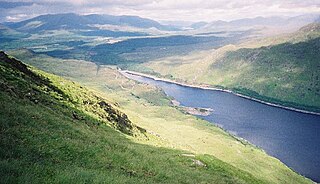
Loch Fyne, is a sea loch off the Firth of Clyde and forms part of the coast of the Cowal peninsula. Located on the west coast of Argyll and Bute, Scotland. It extends 65 kilometres (40 mi) inland from the Sound of Bute, making it the longest of the sea lochs. It is connected to the Sound of Jura by the Crinan Canal. Although there is no evidence that grapes have grown there, the title is probably honorific, indicating that the river, "Abhainn Fìne", was a well-respected river.

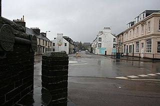
Ardrishaig is a lochside village at the southern (eastern) entrance to the Crinan Canal in Argyll and Bute in the west of Scotland. Ardrishaig had 1,283 inhabitants in 2001.
Crinan is a name of Gaelic origin and it has a number of contexts:

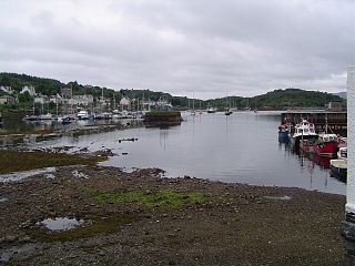
Crinan is a small village located on the west coast of Scotland in the region known as Knapdale, which is part of Argyll and Bute.
Before the Crinan Canal was built, Crinan was named Port Righ which meant the king's port. The canal was named from the small settlement of Crinan Ferry on the edge of Loch Crinan where a small ferry landed. The name Crinan probably derives from the Creones tribe who lived in the area in 140 AD.
The canal starts at Ardrishaig sea lock on Loch Gilp, and ends nine miles away at Crinan sea lock on the Sound of Jura. The canal was designed to provide a short cut between the west coast and islands at one end and the Clyde estuary at the other, and so avoid the long voyage around the south end of the Kintyre Peninsula.
Loch Treig is a 9 km freshwater loch situated in a steep-sided glen 20 km east of Fort William, in Lochaber, Highland, Scotland. While there are no roads alongside the loch, the West Highland Line follows its eastern bank.

The Sound of Jura is a strait in Argyll and Bute, Scotland. It is one of the several Sounds of Scotland.

Cairnbaan is a village situated on the Crinan Canal, in Argyll and Bute, western Scotland.

Loch Gilp is a small inlet on Loch Fyne which gives its name to Lochgilphead. The Crinan Canal extends from the loch across to Crinan itself.
National Cycle Route 78 runs from Campbeltown to Inverness. It was officially launched as the Caledonia Way in 2016 as part of the wider redevelopment of Scotland's cycle network.
It runs from the Kintyre peninsula to the Great Glen and the route varies from on road to traffic-free forest trails and canal paths.
East Loch Tarbert, Argyll is a small sea loch on the eastern side of the Kintyre peninsula in Scotland. It is a part of the much larger Loch Fyne. The village of Tarbert lies along the shores of the loch, which is separated from West Loch Tarbert by an isthmus only 1.5 kilometres (0.93 mi) long.

The Black Loch is a small freshwater loch or reservoir in the Falkirk council area, Scotland. It is near the village of Limerigg and close to the boundary with North Lanarkshire.
Loch Crinan is a seawater loch on the West of Scotland, leading into the Sound of Jura and being the western end of the Crinan Canal. The village of Crinan is at the entrance to the canal at the eastern end of the loch. Duntrune Castle stands on the northern shore. The River Add goes into it by the hamlet of Bellanoch.

Scottish Canals is the public corporation of the Scottish Government responsible for managing the country's inland waterways. Formerly a division of British Waterways, it became a stand-alone public body of the Scottish Government on 2 July 2012. Legally, the corporation is still referred to as the British Waterways Board, but in all other aspects it uses the brand Scottish Canals and intends to steadily roll out this brand over the network.

Cam Loch is one of a number of water supply sources for the Crinan Canal. The impounding reservoir lies to the south of the canal and about 3 kilometres west of Lochgilphead. It has an earthwork dam 8.5 metres high, with records showing that construction was before 1860.

Daill Loch is an impounding reservoir located 5 kilometres west north west of Lochgilphead and 1.5 kilometres south of the Crinan Canal. It is one of a number of lochs supplying water to the canal. The earthen dam is 8.1 metres high and was completed in 1930.

Loch A' Bharain is an impounding reservoir which sits directly on the north bank of the Crinan Canal beside lock No.9, 1.5 kilometres west of Cairnbaan, and is one of a number of reservoirs supplying water to the canal. The earthfill dam is 5.6 metres high and was constructed before 1801.