A natural arch, natural bridge, or rock arch is a natural rock formation where an arch has formed with an opening underneath. Natural arches commonly form where inland cliffs, coastal cliffs, fins or stacks are subject to erosion from the sea, rivers or weathering.

The Springbrook National Park is a protected national park that is located in the Gold Coast hinterland of Queensland, Australia. The 6,197-hectare (15,310-acre) park is situated on the McPherson Range, near Springbrook, approximately 100 kilometres (62 mi) south of Brisbane. The park is part of the Shield Volcano Group of the UNESCO World Heritage–listed Gondwana Rainforests of Australia.

In archaeology, rock art is human-made markings placed on natural stone; it is largely synonymous with parietal art. A global phenomenon, rock art is found in many culturally diverse regions of the world. It has been produced in many contexts throughout human history, although the majority of rock art that has been ethnographically recorded has been produced as a part of ritual. Such artworks are often divided into three forms: petroglyphs, which are carved into the rock surface, pictographs, which are painted onto the surface, and earth figures, formed on the ground. The oldest known rock art dates from the Upper Palaeolithic period, having been found in Europe, Australia, Asia and Africa. Archaeologists studying these artworks believe that they likely had magico-religious significance.

The Tank Stream is a heritage-listed former fresh water tributary of Sydney Cove and now tunnel and watercourse located in the Sydney central business district, in the City of Sydney local government area of New South Wales, Australia. The Tank Stream was the fresh water supply for the fledgling colony of New South Wales in the late 18th century. Today it is little more than a storm water drain. It originated from a swamp to the west of present-day Hyde Park and at high tide entered Sydney Cove at what is now the intersection of Bridge and Pitt Streets in the Sydney central business district. The catchment was 65 hectares, corresponding roughly the size of the Sydney central business district. It was added to the New South Wales State Heritage Register on 2 April 1999.

The Pyrmont Bridge, a heritage-listed swing bridge across Cockle Bay, is located in Darling Harbour, part of Port Jackson, west of the central business district in the City of Sydney local government area of New South Wales, Australia. Opened in 1902, the bridge initially carried motor vehicle traffic via the Pyrmont Bridge Road between the central business district and Pyrmont. Since 1981 the bridge has carried pedestrian and bicycle traffic only, as motor vehicles were diverted to adjacent freeway overpasses. The bridge was added to the New South Wales State Heritage Register on 28 June 2002.

The Glebe Island Bridge is a heritage-listed disused swing road bridge over Rozelle Bay, located at Bank Street, Victoria Road, in the inner city Sydney suburb of Pyrmont in the City of Sydney local government area of New South Wales, Australia. The bridge, which connects Rozelle to Pyrmont by road, is one of the last remaining swing bridges of its type in Australia and in the world. It was designed by Percy Allan and built from 1899 to 1903 by Bridges Branch of NSW Public Works Department. It is also known as RMS Bridge No. 61. It was added to the New South Wales State Heritage Register on 29 November 2013.

Blanchetown is a small township in South Australia, on the (west) bank of the Murray River, 130 km northeast of Adelaide. The Blanchetown Bridge is the western-most of the four crossings of the Sturt Highway over the Murray River. During the nineteenth century it was an important transportation centre on the lower Murray. In modern times Blanchetown has been described as "a strange mixture of historic buildings and temporary shacks built by holidaymakers on the banks of the river". Blanchetown is widely regarded as the entrance to the Riverland district.

The Sault Ste. Marie Canal is a National Historic Site in Sault Ste. Marie, Ontario, and is part of the national park system, managed by Parks Canada. It includes a lock to bypass the rapids on the St. Marys River.
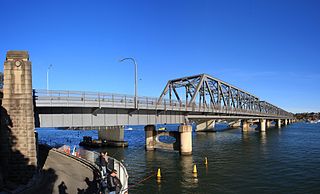
Tom Uglys Bridge is composed of two bridges, completed in 1929 and 1987, that cross Georges River in southern Sydney, in the state of New South Wales, Australia. The bridges link the St George area at Blakehurst to the Sutherland Shire at Sylvania. Tom Uglys Bridge is one of six major road crossings of Georges River.

Maroochy River is a hinterland locality in the Sunshine Coast Region, Queensland, Australia. In the 2011 census, Maroochy River had a population of 1,337 people.

Belubula River, a perennial river that is part of the Lachlan catchment within the Murray–Darling basin, is located in the central west region of New South Wales, Australia.

Diepkloof Rock Shelter is a rock shelter in Western Cape, South Africa in which has been found some of the earliest evidence of the human use of symbols, in the form of patterns engraved upon ostrich eggshell water containers. These date around 60,000 years ago.

The Three Natural Bridges are a series of natural limestone bridges located in Xiannüshan Town (仙女山镇), Wulong District, Chongqing Municipality, China. They lie within the Wulong Karst National Geology Park, itself a part of the South China Karst-Wulong Karst UNESCO World Heritage Site. In Chinese, the bridges are all named after dragons, namely Tianlong Qinglong and Heilong.

Chinamans Hat Island is an islet located off the south coast of Yorke Peninsula in Investigator Strait in South Australia about 2.4 kilometres south-west of Stenhouse Bay and within 350 metres of the shore. As of 2014, it is located within the Innes National Park.

Eba Island Conservation Park is a protected area in the Australian state of South Australia. It comprises 134 hectares of land, proclaimed in 1972 to conserve island habitat within Streaky Bay and sea bird breeding colonies. Eba Island is located 700 metres offshore and 4 kilometres south of Perlubie Hill. It is entirely composed of calcarenite, often overlaid with a limestone capping.

The Cooks River Sewage Aqueduct is an heritage-listed sewage aqueduct located at Pine Street, Earlwood, New South Wales, Australia. It crosses the Cooks River to Thornley Street, Marrickville. It was designed by Sewerage Construction Branch and NSW Department of Public Works and built during 1895 by J. F. Carson, contractor. The property is owned by Sydney Water, an agency of the Government of New South Wales. It was added to the New South Wales State Heritage Register on 18 November 1999.

The Wolli Creek Aqueduct is an heritage-listed sewage aqueduct located at Unwin Street, Earlwood, Canterbury-Bankstown Council, New South Wales, Australia. It crosses Wolli Creek to Thompson Street, Turella. It was designed by Public Works Department and built from 1895 to 1895 by the NSW Public Works Department. The property is owned by Sydney Water, an agency of the Government of New South Wales. It was added to the New South Wales State Heritage Register on 18 November 1999.

The Mosman Bay Sewage Aqueduct is an heritage-listed public pedestrian bridge and sewage aqueduct at Avenue Road, Mosman in the Mosman Council local government area of New South Wales, Australia. It was designed by Sewerage Construction Branch and NSW Department of Public Works and built from 1899 to 1901 by NSW Department of Public Works. It is also known as the Aqueduct over Mosman's Bay. The property is owned by Sydney Water, an agency of the Government of New South Wales. It was added to the New South Wales State Heritage Register on 18 November 1999.

Stonequarry Creek railway viaduct is a heritage-listed railway viaduct over the Stonequarry Creek located on the Main Southern railway in the south-western Sydney town of Picton in the Wollondilly Shire local government area of New South Wales, Australia. It was designed by John Whitton as the Engineer-in-Chief for Railways and was built from 1863 to 1867 by Murnin and Brown. It is also known as Stonequarry Creek Railway Viaduct and Picton railway viaduct over Stonequarry Creek. The property is owned by RailCorp, an agency of the Government of New South Wales. It was added to the New South Wales State Heritage Register on 2 April 1999.

The Bowenfels rail viaducts are a series of heritage-listed railway viaducts and railway bridges over Farmers Creek on the Main Western line in Bowenfels, City of Lithgow, New South Wales, Australia. It was designed in two stages, by John Whitton as the Engineer-in-Chief for Railways, in 1870; and by engineering staff of New South Wales Government Railways in 1921; and was built from 1870 to 1921. It is also known as Farmers Creek viaducts. The property is owned by RailCorp, an agency of the Government of New South Wales. It was added to the New South Wales State Heritage Register on 2 April 1999. The viaduct are located approximately 159 kilometres (99 mi) west of Central railway station.