Green belt (disambiguation)

Last updated

Green belt or greenbelt is an area of protected open space around an urban area.

Green belt largely undeveloped, wild, or agricultural land surrounding urban areas

A green belt or greenbelt is a policy and land use zone designation used in land use planning to retain areas of largely undeveloped, wild, or agricultural land surrounding or neighbouring urban areas. Similar concepts are greenways or green wedges which have a linear character and may run through an urban area instead of around it. In essence, a green belt is an invisible line designating a border around a certain area, preventing development of the area and allowing wildlife to return and be established.

Contents

Green belt may also refer to:

Open spaces

Canada

Greenbelt (Golden Horseshoe) permanently protected area of green space, farmland, forests, wetlands, and watersheds, in Southern Ontario, Canada

The Greenbelt is a permanently protected area of green space, farmland, forests, wetlands, and watersheds, located in Southern Ontario, Canada. It surrounds a significant portion of Canada's most populated and fastest-growing area—the Golden Horseshoe.

Greenbelt (Ottawa) protected area of green space, including farms, forests and wetlands encircling Ottawa, Ontario, Canada

The Greenbelt is a 203.5-square-kilometre (78.6 sq mi) protected area of green space, including forests, farms, and wetlands, that encircles Canada's capital city of Ottawa, in the province of Ontario. It begins at Shirleys Bay in the west and extends to Green's Creek in the east. 149.5 square kilometres (57.7 sq mi) of the greenbelt is owned and managed by the National Capital Commission (NCC) and the rest is held by other federal government departments and private interests. Real estate development within the greenbelt is strictly controlled.

United States

Barton Creek Greenbelt

The Barton Creek Greenbelt located in Austin, Texas is managed by the City of Austin's Park and Recreation Department. The Greenbelt is a 7.25-mile (11.67 km) stretch of public land that begins at Zilker Park and stretches South/Southwest to the final section commonly referred to as "The Hill of Life" which ends in the Woods of Westlake subdivision. The Barton Creek Greenbelt consists of three areas: the Lower Greenbelt, the Upper Greenbelt, and the Barton Creek Wilderness Park and is characterized by large limestone cliffs, dense foliage, and shallow bodies of water.

Staten Island Greenbelt

The Staten Island Greenbelt is a system of contiguous public parkland and natural areas in the central hills of the New York City borough of Staten Island. It is the second largest component of the parks owned by the New York City government and is maintained by the city's Department of Parks and Recreation and the Greenbelt Conservancy, a not-for-profit organization that works in partnership with NYC Parks to care for the Greenbelt and raise funds for its maintenance and programs.

The Long Beach Greenbelt is different from the traditional notion of community recreational parks. Originally slated to become a block of self-storage units, it was instead transformed by community activists into an open space habitat for California native plants.

Other places

European Green Belt

The European Green Belt initiative is a grassroots movement for nature conservation and sustainable development along the corridor of the former Iron Curtain. The term refers to both an environmental initiative as well as the area it concerns. The initiative is carried out under the patronage of the International Union for Conservation of Nature and Mikhail Gorbachev. It is the aim of the initiative to create the backbone of an ecological network that runs from the Barents to the Black and Adriatic Seas.

German Green Belt

The German Green Belt is a project of Bund Naturschutz (BUND), one of Germany's largest environmental groups. The project began in 1989 facing a forbidding, 870-mile (1,400 km) network of fences and guard towers once ran the length of Germany, separating East and West. Now, one of the world's most unusual nature reserves is being created along the old "Death Strip," turning a monument to repression into a symbol of renewal.

Green belt (United Kingdom)

In British town planning, the green belt is a policy for controlling urban growth. The idea is for a ring of countryside where urbanisation will be resisted for the foreseeable future, maintaining an area where agriculture, forestry and outdoor leisure can be expected to prevail. The fundamental aim of green belt policy is to prevent urban sprawl by keeping land permanently open, and consequently the most important attribute of green belts is their openness.

Places

Greenbelt, Maryland City in Maryland, United States

Greenbelt is a city in Prince George's County, Maryland, United States, and a suburb of Washington, D.C.. Greenbelt is notable for being the first and the largest of the three experimental and controversial New Deal Greenbelt Towns, planned and built by the Federal government of the United States. The cooperative community was conceived in 1935, by Undersecretary of Agriculture Rexford Guy Tugwell, who was perceived by some of his contemporaries as having held a collectivist ideology and was utilized as a source of opposition to the Greenbelt Towns project throughout its short duration. The project came into legal existence in the spring of 1935. On April 8, 1935, the United States Congress passed the Emergency Relief Appropriation Act of 1935. Under the authority granted to him from this legislation, President Franklin D. Roosevelt issued an executive order, on May 1, 1935, establishing the United States Resettlement Administration (RA/RRA).

Greenbelt station Washington, DC Metro and Maryland MARC station in Prince Georges County, Maryland, Green and Camden Lines

Greenbelt is a Washington Metro and MARC station in Prince George's County, Maryland on the Green Line. It is the northeastern terminus station of the Green Line.

Greenbelt Historic District National Historic Landmark District in Prince George’s County, Maryland, United States

The Greenbelt Historic District is a national historic district located in Greenbelt, Prince George's County, Maryland, United States. The district preserves the center of one of the few examples of the Garden city movement in the United States. With its sister cities of Greenhills, Ohio and Greendale, Wisconsin, Greenbelt was intended to be a "new town" that would start with a clean slate to do away with problems of urbanism in favor of a suburban ideal. Along with the never-commenced town of Greenbrook, New Jersey, the new towns were part of the New Deal public works programs.

Roads and paths

Other uses

See also

Related Research Articles

Foreign relations of the Dominican Republic

The Dominican Republic has a close relationship with the United States and with the other states of the Inter-American system. It has accredited diplomatic missions in most Western Hemisphere countries and in principal European capitals.

An urban growth boundary, or UGB, is a regional boundary, set in an attempt to control urban sprawl by, in its simplest form, mandating that the area inside the boundary be used for urban development and the area outside be preserved in its natural state or used for agriculture. Legislating for an "urban growth boundary" is one way, among many others, of managing the major challenges posed by unplanned urban growth and the encroachment of cities upon agricultural and rural land.

Makati Highly Urbanized City in National Capital Region, Philippines

Makati,, officially the City of Makati,, or simply known as Makati City, is a 1st class highly urbanized city in Metro Manila, Philippines.

Boise greenbelt

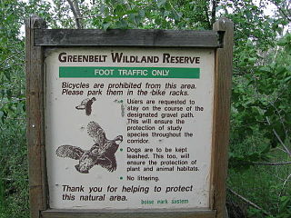
The Boise River Greenbelt is a recreational and alternate transportation trail along the banks of the Boise River through Boise, Idaho, United States. The Boise Greenbelt is more of a greenway than a green belt since its character is linear. It extends more than 20 miles (32 km) beginning at Lucky Peak Dam in the east to a short distance beyond Eagle Road in the west in Eagle, Idaho. Taking into account both sides of the river and other parallel trails and spurs, the total Greenbelt trail system measures more than 30 miles (48 km).

Greenway (landscape) long piece of land, where vegetation and slow travel are encouraged

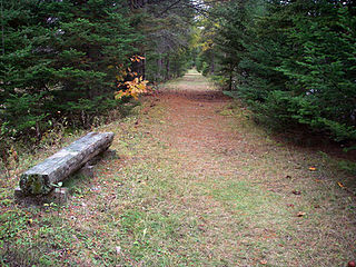
A greenway is "a strip of undeveloped land near an urban area, set aside for recreational use or environmental protection". However, the term can in fact include "a scenic road" and though many are in urban areas, there are some rural greenways, as for example the Monadnock-Sunapee Greenway, a hiking trail in southern New Hampshire.

Ayala Avenue major street in Makati, Philippines

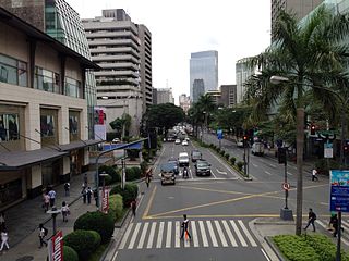
Ayala Avenue is a major thoroughfare in Makati, Philippines. It is one of the busiest roads in Metro Manila, crossing through the heart of the Makati Central Business District. Part of Ayala Avenue forms Circumferential Road 3. Because of the many businesses located along the avenue, Ayala Avenue is nicknamed the Wall Street of the Philippines. It is also a major link between Epifanio de los Santos Avenue (EDSA) and Metropolitan Avenue.

Pan-Philippine Highway highway in the Philippines traversing most of the country

The Pan-Philippine Highway, also known as the Maharlika Highway is a 3,517-kilometer (2,185 mi) network of roads, bridges, and ferry services that connect the islands of Luzon, Samar, Leyte, and Mindanao in the Philippines, serving as the country's principal transport backbone. It is the longest highway in the Philippines that forms the country's north–south backbone component of the National Route 1 (N1) of the Philippine highway network. The entire highway is designated as Asian Highway 26 (AH26) of the Asian Highway Network.

Greenbelt (Ayala Center) shopping mall located at Ayala Center, Makati, Metro Manila, Philippines

Greenbelt is a shopping mall located at Ayala Center, Makati, Metro Manila, Philippines which is just near Glorietta and SM Makati. It is owned by Ayala Malls, a real-estate subsidiary of Ayala Land, which is an affiliate of Ayala Corporation. It opened in the 1988 and is one of Ayala Corporation's flagship projects. The mall offers a mix of high-end retail shops, restaurants, amenities, leisure and entertainment. Currently, the mall has five sections: two enclosed areas, two buildings with open-air shopping areas, and Greenbelt 5, which opened in 2007.

Open space reserve green area planned in an urban location

An open space reserve is an area of protected or conserved land or water on which development is indefinitely set aside.

Tourism in Metro Manila

Tourism is an important industry in Metro Manila, Philippines. In 2012, the city and region welcomed 974,379 overnight visitors. As the main gateway to the Philippines' many destinations, the city is visited by the majority of international tourists to the country registering a total of 3,139,756 arrivals in 2012. Global Blue ranked Manila eleventh in its "Best Shopping Destinations" in Asia. The city is ranked tenth in MasterCard's global top 20 fastest growing cities for international visitors from 2009-2013.

Numerous events and festivals are held annually in Metro Manila. They include:

Gil Puyat Avenue road in the Philippines

The Gil Puyat Avenue, formerly and still referred to as Buendia Avenue, is a major arterial thoroughfare which travels east–west through the cities of Makati and Pasay in western Metro Manila, Philippines. It is one of the busiest avenues in Metro Manila linking the Makati Central Business District with the rest of the metropolis. Its western end begins at Roxas Boulevard and continues through San Isidro District, Pasay until intersecting with Taft Avenue. Past the intersection with the elevated Gil Puyat LRT Station, the road runs through Tramo Street and Barangay Palanan in Makati. East of Osmeña Highway, Gil Puyat intersects with the busy streets of the Central Business District before finally reaching its terminus at Epifanio de los Santos Avenue (EDSA).

Makati Avenue road in the Philippines

Makati Avenue is a major commercial thoroughfare in Makati, Metro Manila, Philippines. It forms the eastern border of Ayala Triangle and is one of the three main avenues of the Makati Central Business District. The avenue runs in a somewhat north-south diagonal direction almost parallel with Epifanio de los Santos Avenue (EDSA). It passes through two distinct neighborhoods of the city: the Makati CBD and the old Makati Población. At its northern end lies the older part of Makati starting from the Makati-Mandaluyong Bridge and J.P. Rizal Avenue. It continues through Población to Gil Puyat Avenue, marking the southern edge of the old district. South of Gil Puyat onto the CBD, the avenue becomes more commercial and upscale. The shopping hub of Ayala Center and Arnaiz Avenue lie at its southern end.

Makati Central Business District Central Business District in National Capital Region, Philippines

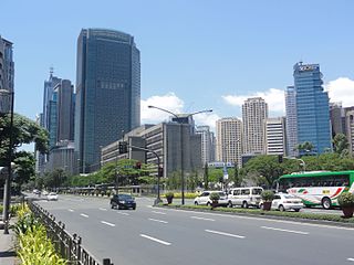
The Makati Central Business District, also known as the Makati CBD, is the leading financial and central business district in the Philippines located at the heart of Makati in Metro Manila. It is politically known as "Central Cluster" in the West District of Makati. It is different from the civic center of Makati known as "Makati Poblacion" which is situated at the north-east portion of the district. It is bounded by EDSA, Gil Puyat Avenue, Arnaiz Avenue, and Chino Roces Avenue. The whole district occupies barangays of San Antonio, San Lorenzo, Bel-Air, and Urdaneta.

South and West Yorkshire Green Belt


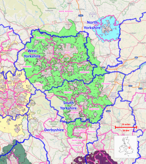
The South and West Yorkshire Green Belt is a green belt environmental and planning policy that regulates the rural space within the Yorkshire and the Humber region of England. It is contained within the counties of South Yorkshire and West Yorkshire, North Yorkshire, and Derbyshire. Essentially, its primary function is to more rigorously manage development around the cities, towns and villages in the large West Yorkshire Urban Area-, the Sheffield urban area and surrounding towns of Barnsley, Doncaster, Rotherham, as well as other nearby locations, in order to discourage urban sprawl and further convergence between these. It is managed by local planning authorities on guidance from central government.

Avon Green Belt

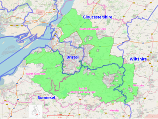
The Avon Green Belt, also known as the Bristol and Bath Green Belt, is a non-statutory green belt environmental and planning policy that regulates urban expansion and development in the countryside surrounding the cities of Bristol and Bath in the South West region of England. It covers areas in Bristol, South Gloucestershire, North Somerset, Bath and North East Somerset, Mendip, and Wiltshire. Essentially, the function of the green belt is to limit urban sprawl and maintain the open character of areas around the Bristol and Bath built up areas, and nearby towns and villages. The policy is implemented by local planning authorities on the basis of guidance from central government.