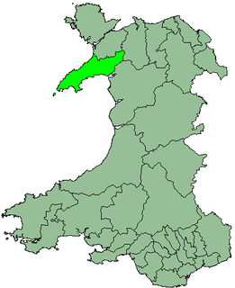
| Gwyrfai | |
|---|---|
| Area | |
| • 1901 | 70,441 acres (285.06 km2) |
| • 1934 | 96,475 acres (390.42 km2) |
| Population | |
| • 1901 | 29,838 |
| • 1971 | 21,234 |
| History | |
| • Created | 1894 |
| • Abolished | 1974 |
| • Succeeded by | Arfon, Dwyfor |
| Status | Rural District |
| • HQ | Caernarvon |
Gwyrfai was a rural district in the administrative county of Caernarvonshire from 1894 to 1974.
Rural districts were a type of local government area – now superseded – established at the end of the 19th century in England, Wales, and Ireland for the administration of predominantly rural areas at a level lower than that of the administrative counties.
An administrative county was an administrative division in England and Wales and Ireland from 1888 to 1974, used for the purposes of local government. They are now abolished, although in Northern Ireland their former areas are used as the basis for lieutenancy.
The district was formed under the Local Government Act 1894, taking over the area of the Carnarvon Rural Sanitary District. It was named after the Afon Gwyrfai (a river).

The Local Government Act 1894 was an Act of the Parliament of the United Kingdom that reformed local government in England and Wales outside the County of London. The Act followed the reforms carried out at county level under the Local Government Act 1888. The 1894 legislation introduced elected councils at district and parish level.
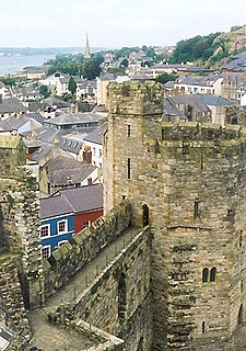
Caernarfon is a royal town, community, and port in Gwynedd, Wales, with a population of 9,615. It lies along the A487 road, on the eastern shore of the Menai Strait, opposite the Isle of Anglesey. The city of Bangor is 8.6 miles (13.8 km) to the north-east, while Snowdonia fringes Caernarfon to the east and south-east. Carnarvon and Caernarvon are Anglicised spellings that were superseded in 1926 and 1974, respectively. The villages of Bontnewydd and Caeathro are close by. The town is also noted for its high percentage of native Welsh speakers. Due to this, Welsh is often the predominant language of the town.
Sanitary districts were established in England and Wales in 1875 and in Ireland in 1878. The districts were of two types, based on existing structures:
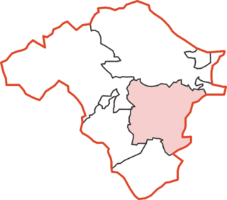
The district as created in 1894 consisted of the following civil parishes:

In England, a civil parish is a type of administrative parish used for local government, they are a territorial designation which is the lowest tier of local government below districts and counties, or their combined form, the unitary authority. Civil parishes can trace their origin to the ancient system of ecclesiastical parishes which historically played a role in both civil and ecclesiastical administration; civil and religious parishes were formally split into two types in the 19th century and are now entirely separate. The unit was devised and rolled out across England in the 1860s.
- Bettws Garmon
- Clynnog
- Llanberis
- Llanddeineolan
- Llandwrog
- Llanfaglan
- Llanfair is Gaer
- Llanllyfni
- Llanrug
- Llanwnda
- Waun Fawr

Betws Garmon is a community and small hamlet outside Waunfawr and near Beddgelert in Gwynedd, Wales. It has a population of 249.
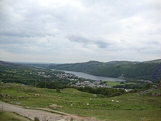
Llanberis is a village, community and electoral ward in Gwynedd, northwest Wales, on the southern bank of the lake Llyn Padarn and at the foot of Snowdon, the highest mountain in Wales. It is a popular centre for outdoor activities in Snowdonia, including walking, mountaineering, climbing, mountain biking and pony trekking as well as water sports such as Scuba Diving. The international fell race known as the Snowdon Race to the summit of Snowdon begins in the village.

Llandwrog is a village and community in Gwynedd, north-west Wales, most notable for the presence of the headquarters of Welsh record label Sain and the site of Caernarfon Airport. It has a population of 2,466, increasing to 2,539 at the 2011 Census. The community includes the villages of Groeslon, Carmel, Gwynedd, Y Fron, Dinas Dinlle, and Cilgwyn.
In 1934, on the abolition of Glaslyn Rural District, the parish of Beddgelert was added.
Glaslyn was a rural district in the administrative county of Caernarfonshire from 1894 to 1934.

Beddgelert is a village and community in the Snowdonia area of Gwynedd, Wales. The population of the community taken at the 2011 census was 455. It is reputed to be named after the legendary hound Gelert.
The district was abolished in 1974 by the Local Government Act 1972. Beddgelert and Clynnog were included in the district of Dwyfor, with the rest of the rural district becoming part of the Borough of Arfon, both in the new county of Gwynedd.
The Local Government Act 1972 is an Act of the Parliament of the United Kingdom that reformed local government in England and Wales on 1 April 1974.
Dwyfor was one of the five local government districts of Gwynedd, Wales from 1974 to 1996, covering the Llŷn peninsula. Its council was based in Pwllheli.

Gwynedd is a county in Wales, sharing borders with Powys, Conwy, Denbighshire, Anglesey over the Menai Strait, and Ceredigion over the River Dyfi. The scenic Llŷn Peninsula and most of Snowdonia National Park are in Gwynedd. Bangor is the home of Bangor University. In the northern part of the county, the other main settlements are Caernarfon, Bethesda, Ffestiniog, Llanddeiniolen, Llanllyfni, Porthmadog and Pwllheli. The largest settlement in the south is Tywyn.