The Metropolitan Borough of Tameside is a metropolitan borough of Greater Manchester in North West England. It is named after the River Tame, which flows through the borough and spans the towns of Ashton-under-Lyne, Audenshaw, Denton, Droylsden, Dukinfield, Hyde, Mossley and Stalybridge plus Longdendale. Its western border is approximately 4 miles (6.4 km) east of Manchester city centre. It borders High Peak in Derbyshire to the east, the Metropolitan Borough of Oldham to the north, the Metropolitan Borough of Stockport to the south, and the City of Manchester to the west. As of 2011 the overall population was 219,324.

Ashton-under-Lyne is a market town in Tameside, Greater Manchester, England. The population was 45,198 at the 2011 census. Historically in Lancashire, it is on the north bank of the River Tame, in the foothills of the Pennines, 6.2 miles (10.0 km) east of Manchester.
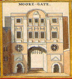
Moorgate was a postern in the London Wall originally built by the Romans. It was turned into a gate in the 15th century. Though the gate was demolished in 1762, the name survives as a major street in the City of London. The street connects the City to the London Boroughs of Islington and Hackney, and was constructed around 1846 as one of the new approaches to London Bridge.

Mossley Association Football Club is a football club in Mossley, Greater Manchester, England. Nicknamed the Lilywhites after the white shirts adopted in 1912, they are currently members of the Northern Premier League Division One West and play at Seel Park.

The Huddersfield Narrow Canal is an inland waterway in northern England. It runs just under 20 miles (32 km) from Lock 1E at the rear of the University of Huddersfield campus, near Aspley Basin in Huddersfield, to the junction with the Ashton Canal at Whitelands Basin in Ashton-under-Lyne. It crosses the Pennines by means of 74 locks and the Standedge Tunnel.

The Huddersfield line is one of the busiest rail lines on the West Yorkshire MetroTrain network in Northern England. Local services are operated by Northern with longer distance services operated by TransPennine Express. The line connects Leeds and Huddersfield with Manchester, Manchester Airport and Liverpool.

Wythenshawe is an area of south Manchester, England.

Stalybridge and Hyde is a constituency represented in the House of Commons of the UK Parliament since 2010 by Jonathan Reynolds, a member of the Labour Party and the Cooperative Party.

The Huddersfield Narrow Canal Pylon,, is an electricity pylon which stands with its feet over the Huddersfield Narrow Canal near Heyrod, Stalybridge, Greater Manchester, United Kingdom.

Carrbrook is an area in the east of Stalybridge, in Greater Manchester, England. The area still has many seventeenth and eighteenth century buildings. Much of the late-nineteenth and early-twentieth century village was built during the industrial boom brought by the printworks. Modern Housing estates were built next to the old village on the lower flank of Harridge Pike from the 1970s. The view to the east of Carrbrook is dominated by the steep-sided Buckton Hill, on the summit of which is located Buckton Castle. Neighbouring communities include Millbrook, Heyheads and Micklehurst.

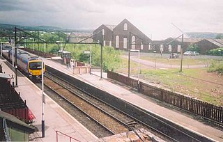
Greenfield railway station in the village of Greenfield, Greater Manchester, England, is on the Huddersfield Line 12 miles (20 km) northeast of Manchester Victoria. It is the final station in Greater Manchester before the West Yorkshire boundary.
Guide Bridge railway station serves Guide Bridge in Audenshaw, Greater Manchester, England, and is operated by Northern. The station is 4¾ miles east of Manchester Piccadilly on the Glossop Line.

The A635 is a main road that runs between Manchester and Scawsby running east–west through Stalybridge, Saddleworth Moor, Holmfirth, Barnsley and Doncaster.
The section forming the eastern part of the Mancunian Way is in fact a motorway and is officially designated as the A635(M) though there is no road sign with this designation; indeed the signs at the entrance of Mancunian Way westbound show A57(M).
The Moss Rose is a multi-purpose stadium in Macclesfield, Cheshire, England, situated approximately one mile (1.6km) south of the town centre, on the west side of the A523 London Road. It is currently used primarily for football matches and is the home ground of Macclesfield Town F.C.. The stadium holds 6,355 and was built in 1891, making it one of the oldest grounds in the Football League.

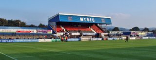
Bower Fold in Stalybridge, Greater Manchester, England, is the home ground of Stalybridge Celtic football club.

Middlestown is a small village in between Wakefield and Huddersfield, West Yorkshire, England. The village is in the civil parish of Sitlington.
Hooley Hill Railway Station served the Hooley Hill area of Audenshaw and was located on the Denton to Stalybridge Stalybridge Junction Railway. This was built & opened by the London and North Western Railway in 1893 to avoid the busy junctions at Guide Bridge and provide the company with its own route between Stalybridge & Stockport. The Bradshaws timetable for 1922 listed 11 southbound & 12 northbound trains calling on Mondays to Saturdays, but none on Sundays.

Stalybridge Mill, Stalybridge is a cotton spinning mill in Stalybridge, Tameside, Greater Manchester. It was built in 1868, and the engine reconfigured in around 1925. It was taken over by the Lancashire Cotton Corporation in the 1930s and passed to Courtaulds in 1964.
Stalybridge is a town in Tameside, Greater Manchester, England. The town, together with the village of Millbrook and the surrounding countryside, contains 55 listed buildings that are recorded in the National Heritage List for England. Of these, two are listed at Grade II*, the middle grade, and the others are at Grade II, the lowest grade. Initially rural and agricultural, the cotton industry came to the area in 1776. The older listed buildings are houses, farmhouses and farm buildings, and later listed buildings include structures associated with the Huddersfield Narrow Canal, mills, public houses, schools, churches, civic buildings, a bridge, and a war memorial.