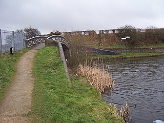
The Wyrley and Essington Canal, known locally as "the Curly Wyrley", is a canal in the English Midlands. As built it ran from Wolverhampton to Huddlesford Junction near Lichfield, with a number of branches: some parts are currently derelict. Pending planned restoration to Huddlesford, the navigable mainline now terminates at Ogley Junction near Brownhills. In 2008 it was designated a Local Nature Reserve.

East Staffordshire is a local government district with borough status in Staffordshire in England. It has two main towns: Burton upon Trent, famous for its breweries, and Uttoxeter, renowned for its racecourse.

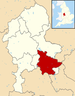
South Staffordshire is a local government district in Staffordshire, England. The district lies to the north and west of the West Midlands county, bordering Shropshire to the west and Worcestershire to the south. It contains no towns of major size, and many of the settlements within the district are considered dormitory villages for Stafford, Telford, and the West Midlands conurbation.
Lichfield is a local government district in Staffordshire, England. It is administered by Lichfield District Council, based in Lichfield.

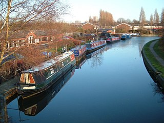
The Lichfield Canal, as it is now known, was historically a part of the Wyrley and Essington Canal, being the section of that canal from Ogley Junction at Brownhills on the northern Birmingham Canal Navigations to Huddlesford Junction, east of Lichfield, on the Coventry Canal, a length of 7 miles (11.3 km). The branch was abandoned in 1955, along with several other branches of the Wyrley and Essington, and much of it was filled in.

The A5127 is a major road in England which runs between Birmingham and Lichfield, Staffordshire. For much of the route the road follows the old route of the A38 which has since been moved in order to by-pass places such as Erdington and Sutton Coldfield and form a relief road from Birmingham city centre to Spaghetti Junction.

Kinver is a large village in South Staffordshire district, Staffordshire, England. It is in the far south-west of the county, at the end of the narrow finger of land surrounded by the counties of Shropshire, Worcestershire and the West Midlands. The nearest towns are Stourbridge, West Midlands, Kidderminster in Worcestershire and Bridgnorth, Shropshire. The Staffordshire and Worcestershire Canal passes through, running close to the course of the meandering River Stour. According to the 2011 census Kinver ward had a population of 7,225.
Acton Trussell, Bednall is a civil parish in the South Staffordshire district of Staffordshire, England. As the name indicates, it contains the two villages Acton Trussell, Bednall. Teddesley Hay is part of the grouped parish council. The population of the civil parish at the 2011 census was 1,248.

Fazeley Junction is the name of the canal junction where the authorised Birmingham and Fazeley Canal terminates and meets the Coventry Canal at Fazeley, near Tamworth, Staffordshire, England.

Horseley Fields Junction is a canal junction at the western limit of the Wyrley and Essington Canal where it meets the BCN Main Line, at Horseley Fields east of Wolverhampton, in the West Midlands, England.
Ogley Junction, on the Staffordshire county border near Brownhills, West Midlands, England, is a historic canal junction on the Wyrley and Essington Canal where the Anglesey Branch left the main line.

Pelsall Junction is a canal junction at the southern limit of the Cannock Extension Canal where it meets the Wyrley and Essington Canal main line, near Pelsall, West Midlands, England.

Birchills Junction is the canal junction at the northern limit of what is now called the Walsall Canal where it meets the Wyrley and Essington Canal main line, near Walsall, West Midlands, England. It opened in 1798, but lasted for little more than a year, until it was re-opened in 1841 when a connecting link was built to the Birmingham Canal Navigations' southern route to Walsall.
Whittington Old Hall is a 16th-century mansion house at Whittington, Staffordshire, England, which has been subdivided into separate residential apartments. It is a Grade II* listed building.

Packington Hall in Staffordshire was an English country house designed by architect James Wyatt in the 18th century. Originally built for the Babington family, it became the home of the Levett family for many generations. The Levetts had ties to Whittington, Staffordshire and nearby Hopwas for many years.

Lichfield District Council is a non metropolitan district council, which covers the district of Lichfield in Staffordshire, England. It was formed in 1974 from Lichfield City Council and Lichfield Rural District Council. The council offices are located at the District Council House on Frog Lane, in the centre of Lichfield.
South Staffordshire College is a further education college located over four sites in Staffordshire, England.
Whittington is a civil parish in the district of Lichfield, Staffordshire, England. It contains 20 buildings that are recorded in the National Heritage List for England. Of these, one is listed at Grade II*, the middle of the three grades, and the others are at Grade II, the lowest grade. The parish contains the villages of Whittington and Huddlesford and the surrounding countryside. Most of the listed buildings are houses and associated structures, cottages, farmhouses and farm buildings. In the parish is Whittington Barracks, and the listed buildings here are the keep, a garrison church, and two war memorials. The Coventry Canal and the Birmingham and Fazeley Canal pass through the parish, and a bridge over each of these is listed. The other listed buildings are a church, a memorial in the churchyard, a former school, and another war memorial.


