King's Norton, Leicestershire

Last updated

King's Norton direction post King's Norton - geograph.org.uk - 500579.jpg
King's Norton direction post

King's Norton is a village and civil parish in the Harborough district of Leicestershire, England. It is situated to the east of Leicester, and about 2 12 miles (4 km) south-west from Billesdon. According to the 2001 census the parish had a population of 69. At the 2011 census the population remained less than 100 and is included in the civil parish of Gaulby.

Civil parish territorial designation and lowest tier of local government in England, UK

In England, a civil parish is a type of administrative parish used for local government, they are a territorial designation which is the lowest tier of local government below districts and counties, or their combined form, the unitary authority. Civil parishes can trace their origin to the ancient system of ecclesiastical parishes which historically played a role in both civil and ecclesiastical administration; civil and religious parishes were formally split into two types in the 19th century and are now entirely separate. The unit was devised and rolled out across England in the 1860s.

Harborough District District in England

Harborough is a local government district of Leicestershire, England, named after its main town, Market Harborough. Covering 230 square miles (600 km2), the district is by far the largest of the eight district authorities in Leicestershire and covers almost a quarter of the county.

Leicestershire County of England

Leicestershire is a landlocked county in the English Midlands. The county borders Nottinghamshire to the north, Lincolnshire to the north-east, Rutland to the east, Northamptonshire to the south-east, Warwickshire to the south-west, Staffordshire to the west, and Derbyshire to the north-west. The border with most of Warwickshire is Watling Street.

Contents

There is a small cluster of houses around the junction of three roads which lead to Gaulby, Little Stretton, and Illston on the Hill; this includes the manor-house, Vicarage, and church. In 1563 there were 12 households, in 1670 there were 17 households. The maximum known population was just over 60 in the 19th century. [1]

Gaulby village in the United Kingdom

Gaulby is a village in Leicestershire, England, 7 miles east of the city of Leicester. According to the 2001 census it had a population of 131,. including King's Norton and increasing to 241 at the 2011 census.

Illston on the Hill village in the United Kingdom

Illston on the Hill is a small village and parish seven miles north of Market Harborough in the county of Leicestershire. The population of the civil parish at the 2011 census was 179. The old part of Illston is a rare "dead end" village: literally, at the end of the road which leads to it. Illston has a small but thriving pub, drawing trade from several miles around, serving Everard's beers. The pub's walls are crowded with an eclectic array of rural memorabilia including mounted fox heads, stuffed animals and historic gin traps, as well as a number of cartoons by local resident Ed McLachlan. Illston also has a village hall available for rent. In the summer it hosts events including a Village Fete and 'Onion Sunday'.

Manor house and other houses

The L-shaped manor house is adjacent to the east end of the church. Most of the two storey (plus attics) main structure was probably built by William Whalley (d.1635) or his son Ralph. Sash windows were inserted into the main wing (red brick on an ironstone plinth) in the early 18th century. There is a mid-17th century staircase which has been altered. The old kitchen was in the smaller wing; the kitchen is now in a previous brew-house c.1800. The roof of this wing has an arch-braced collar-beam truss. [1]

Also on this plot is a square brick dovecote with a small diaper pattern (poss. later 17th century). There is a tablet dated 1726 with the initials of Bernard and Anne Whalley on another building. [1]

Dovecote structure intended to house pigeons or doves

A dovecote or dovecot or doocot is a structure intended to house pigeons or doves. Dovecotes may be free-standing structures in a variety of shapes, or built into the end of a house or barn. They generally contain pigeonholes for the birds to nest. Pigeons and doves were an important food source historically in Western Europe and were kept for their eggs, flesh, and dung.

Diaper type of underwear that allows one to defecate or urinate, without the use of a toilet

A diaper or a nappy is a type of underwear that allows the wearer to defecate or urinate without the use of a toilet, by absorbing or containing waste products to prevent soiling of outer clothing or the external environment. When diapers become soiled, they require changing, generally by a second person such as a parent or caregiver. Failure to change a diaper on a sufficiently regular basis can result in skin problems around the area covered by the diaper.

Other notable buildings are The Limes, Wyggeston Farm (c1700 plus older fragments), a timber-framed cottage, Lime Cottage (18th century brick), The Grange (1870, formerly The Laurels), the village hall (1921 from Co-operative Society). [1]

Church

The Gothic Revival church of St. John the Baptist was built at the cost of just over £20,000 in a little over one year at the commission of Squire William Fortrey. It was designed by local architect John Wing the Younger (1728-94) of North Luffenham. The spire was added in 1775 but destroyed in a storm in 1850.

Gothic Revival architecture Architectural movement

Gothic Revival is an architectural movement popular in the Western world that began in the late 1740s in England. Its popularity grew rapidly in the early 19th century, when increasingly serious and learned admirers of neo-Gothic styles sought to revive medieval Gothic architecture, in contrast to the neoclassical styles prevalent at the time. Gothic Revival draws features from the original Gothic style, including decorative patterns, finials, lancet windows, hood moulds and label stops.

North Luffenham village in United Kingdom

North Luffenham is a village in Rutland, in the East Midlands of England. The population of the civil parish at the 2001 census was 704, decreasing to 679 at the 2011 census. It lies to the north of the River Chater, 5 miles (8.0 km) east of Uppingham and 7 miles (11 km) west of Stamford. Located to the north of the village is St George's Barracks, formerly RAF North Luffenham.

The interior has hardly changed: the central three-decker pulpit, box pews and west gallery remain, lit by clear windows. Outside at its east end is a monument to William Fortrey, and close by is the 17th-century Fortrey manor house.

Related Research Articles

Great Budworth village in the United Kingdom

Great Budworth is a village and civil parish in Cheshire, England, four miles (6.4 km) north of Northwich off the A559 road, east of Comberbach, northwest of Higher Marston and southeast of Budworth Heath. Until 1948, Great Budworth was part of the Arley Hall estate.

Harwell, Oxfordshire village and civil parish in Vale of White Horse district, Oxfordshire, England

Harwell is a village and civil parish in the Vale of White Horse about 2 miles (3 km) west of Didcot, 6 miles (10 km) east of Wantage and 13 miles (21 km) south of Oxford. The parish measures about 3 12 miles (5.6 km) north – south, and almost 2 miles (3 km) east – west at its widest point. In 1923 its area was 2,521 acres (1,020 ha). Harwell is in the historic county of Berkshire, however since 1974 it has been administered as part of Oxfordshire.

Milton Abbas a village located in North Dorset, United Kingdom

Milton Abbas is a village and civil parish in the county of Dorset in South West England. It is in the North Dorset district, about 5 miles (8.0 km) southwest of Blandford Forum. In the 2011 census the civil parish had a population of 755.

Puddletown village in the United Kingdom

Puddletown is a village and associated civil parish in Dorset, England. The village is situated about 4.5 miles (7 km) northeast of the county town Dorchester and is sited by the River Piddle, from which it derives its name. It also used to be known as Piddletown, but this fell out of favour, probably because of the alternative meaning of the word "piddle". The name Puddletown rather than Piddletown was officially sanctioned in the late 1950s. Puddletown's civil parish covers 2,908 hectares and extends to the neighbouring River Frome to the south. In 2013 the estimated population of the civil parish was 1,450.

Lyndhurst, Hampshire village and civil parish in Hampshire, England

Lyndhurst is a large village and civil parish situated in the New Forest National Park in Hampshire, England. Serving as the administrative capital of the New Forest, it is a popular tourist attraction, with many independent shops, art galleries, cafés, museums, pubs and hotels. The nearest city is Southampton, about nine miles (14 km) to the north-east. As of 2001 Lyndhurst had a population of 2,973, increasing to 3,029 at the 2011 Census. The name derives from an Old English name, comprising the words lind and hyrst.

Drayton, Leicestershire village in the United Kingdom

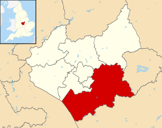
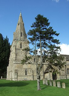
Drayton is a small village and civil parish in the Harborough district of south-east Leicestershire, bordering Northamptonshire and Rutland. It is situated 6.7 miles (11 km) northeast of Market Harborough and 5 miles southwest of Uppingham on the north side of the Welland valley. Nearby villages are Bringhurst, Great Easton and Nevill Holt. The church of St. James in Drayton is one of the smallest churches in England.

Stoke-by-Nayland village in the United Kingdom

Stoke-by-Nayland is a village and civil parish in Suffolk, England, close to the border with Essex. The village, located within Babergh district, contains many cottages and timber framed houses and all surround a large recreation field. Possibly once the site of a monastery, the population of the civil parish at the 2001 census was 703, falling to 682 at the Census 2011.

Waterstock village and civil parish in South Oxfordshire district, Oxfordshire, England

Waterstock is a village and civil parish on the River Thame about 4.5 miles (7 km) west of the market town of Thame in Oxfordshire. The parish is bounded to the north and west by the river, to the south largely by the A418 main road, and to the east largely by the minor road between Tiddington and Ickford Bridge across the Thame. On the north side of the parish, the river forms the county boundary with Buckinghamshire as well as the parish boundary with Ickford and Worminghall.

Betchworth village and civil parish in the Mole Valley district of Surrey, England

Betchworth is a village and civil parish in the Mole Valley district of Surrey, England. The village centre is on the north bank of the River Mole and south of the A25 road, almost 3 miles (4.8 km) east of Dorking and 3 miles (4.8 km) west of Reigate. London is 19.5 miles (31.4 km) north of the village.

Somerford Keynes village in United Kingdom

Somerford Keynes is a small village and civil parish in Gloucestershire, England, close to the River Thames and Thames Path about five miles (8 km) from its source and in the Cotswold Water Park. It lies on the boundary with Wiltshire midway between Cirencester, Swindon and Malmesbury. The parish population at the 2011 census was 479. The first beavers to be born in Britain for 400 years appeared at Lower Mill in 2008.

Saracens Head group of late medieval buildings in Kings Norton, Birmingham

The Saracen's Head is the name formerly given to a group of late medieval buildings in Kings Norton, Birmingham. The buildings, together with the nearby Old Grammar School, won the BBC Restoration series in 2004. Following the restoration project, the Old Grammar School, Saint Nicolas Church and the Tudor Merchant's House were given the collective name of Saint Nicolas Place.

Wistow, Leicestershire village and civil parish in Harborough, Leicestershire, England

Wistow is a hamlet and deserted medieval village in the English county of Leicestershire, and lies seven miles south-east of the city of Leicester in the valley of the River Sence. Since 1936 it has included most of the former civil parish of Newton Harcourt which is a chapelry of Wistow. The population of the civil parish at the 2011 census was 256.

Cornwell, Oxfordshire village and civil parish in West Oxfordshire, England

Cornwell is a village and civil parish about 2.5 miles (4 km) west of Chipping Norton in West Oxfordshire. The 2001 Census recorded the parish's population as 66.

Shalden village in United Kingdom

Shalden is a village and civil parish in the East Hampshire district of Hampshire, England. It is 2.3 miles (3.7 km) northwest of Alton and 1.9 miles (3.1 km) northeast of Bentworth, just off the A339 road. The parish covers an area of 1,536 acres (622 ha) and has an average elevation of 600 feet (180 m) above sea level. The nearest railway station is Alton, 2.5 miles (4.0 km) southeast of the village. According to the 2011 census, it had a population of 435.

Chevington, Suffolk village in Suffolk, United Kingdom

Chevington is a village and civil parish in the St Edmundsbury district of Suffolk in East Anglia, England. Located around 10 km south-west of Bury St Edmunds, in 2005 its population was 630, reducing to 602 at the 2011 Census. The parish also contains the hamlets of Broad Green and Tan Office Green.

Wormleighton Manor

Wormleighton Manor is a manor house in the civil parish of Wormleighton in the historic county of Warwickshire, England. It belonged to the wealthy Spencer family during the 16th and 17th century. Much of the house was burned down by Royalists during the English Civil War in 1645 and abandoned by the Spencers in favour of Althorp, which contains some materials salvaged from Wormleighton to this day. Today, all that is left of the manor, which was once four times the size of Althorp, is the Wormleighton Manor Gatehouse and Tower Cottage which is a Grade II listed building and the northern range of the manor.

Thimbleby, Lincolnshire village and civil parish in East Lindsey, Lincolnshire, England

Thimbleby is a village and civil parish in the East Lindsey district of Lincolnshire, England. It is situated approximately 1 mile (1.6 km) west from the A158 road and the town of Horncastle.

Norton, Buckland and Stone

Norton, Buckland and Stone is a small rural civil parish 1 mile (1.6 km) east of Teynham and 3 miles (4.8 km) west of the centre of Faversham in the borough of Swale, Kent, England. It is bypassed by the M2 to the south and traverses the historic A2, on the route of the Roman road of Watling Street.

Staplecross village in East Sussex, England

Staplecross is a village in the civil parish of Ewhurst and the Rother district of East Sussex, England. Staplecross is the largest settlement in Ewhurst parish, and is on a southern ridge of the valley of the River Rother which flows through Bodiam at the north of Staplecross. The village is in the High Weald Area of Outstanding Natural Beauty. In 2011 it had a population of 760.

References

  1. 1 2 3 4 "Victoria County History". British History Online. VCH. Retrieved 21 November 2015.

Coordinates: 52°35′53″N0°59′06″W / 52.598°N 0.985°W / 52.598; -0.985