The West Midland Bird Club is the UK's largest regional ornithological society. It has been serving birdwatchers and ornithologists in the four English counties of Staffordshire, Warwickshire, Worcestershire and the Metropolitan West Midlands, with lectures, field trips, research, a bulletin and an annual report, since 1929. It is a registered charity in England and Wales, number 213311.

The River Blythe flows through the English Midlands from Southern Warwickshire, through the borough of Solihull and on to Coleshill. It runs along the Meriden Gap in the Midlands Plateau, is fed by the River Cole and is a tributary of the River Tame beside the West Midland Bird Club's Ladywalk reserve. This then joins the River Trent, whose waters reach the North Sea via the Humber Estuary.

The River Cole is a 25 miles (40 km) river in the English Midlands. It rises on the lower slopes of Forhill, one of the south-western ramparts of the Birmingham Plateau, at Hob Hill, near Wythall; and flows largely north-east across the plateau to enter the River Blythe below Coleshill, near Ladywalk, shortly before the Blythe meets the Tame. This then joins the Trent, whose waters reach the North Sea via the Humber Estuary. Its source is very near the main watershed of Midland England : tributaries are few and very short except in the lower reaches, so the Cole is only a small stream.

The United States Navy maintains a number of its ships as part of a reserve fleet, often called the "Mothball Fleet". While the details of the maintenance activity have changed several times, the basics are constant: keep the ships afloat and sufficiently working as to be reactivated quickly in an emergency.

Six Nations is the largest First Nations reserve in Canada. As of the end of 2017, it has a total of 27,276 members, 12,848 of whom live on the reserve. It is the only reserve in North America that has representatives of all six Iroquois nations living together. These nations are the Mohawk, Cayuga, Onondaga, Oneida, Seneca and Tuscarora. Some Lenape also live in the territory.

The River Blackwater is a tributary of the River Loddon in England and, indirectly, of the River Thames. It rises at Rowhill Nature Reserve between Aldershot in Hampshire and Farnham in Surrey and runs northwards to join the Loddon near the village of Swallowfield in Berkshire. Along part of its length, the river forms the boundary between Hampshire and Surrey, and then between Hampshire and Berkshire. It rises in Rowhill Nature Reserve, Aldershot
Rowhill, an isolated remnant of the extensive heathland that once surrounded Farnborough and Aldershot. After 20 miles (32 km) the Blackwater is joined by the River Whitewater near Eversley. The river gives its name to the small town of Blackwater, Hampshire, upon the river near Camberley.

The Satpura Range is a range of hills in central India. The range rises in eastern Gujarat state running east through the border of Maharashtra and Madhya Pradesh to the east till Chhattisgarh. The range parallels the Vindhya Range to the north, and these two east-west ranges divide Indian Subcontinent into the Indo-Gangetic plain of northern India and the Deccan Plateau of the south. The Narmada River originates from north-eastern end of Satpura and runs in the depression between the Satpura and Vindhya ranges, draining the northern slope of the Satpura range, running west towards the Arabian Sea. The Tapti River originates in the eastern-central part of Satpura, crossing the range in the center and running west at the range's southern slopes before meeting the Arabian Sea at Surat, draining the central and southern slopes of the range. The Godavari River and its tributaries drain the Deccan plateau, which lies south of the range, and the Mahanadi River drains the easternmost portion of the range. The Godavari and Mahanadi rivers flow into the Bay of Bengal. At its eastern end, the Satpura range meets the hills of the Chotanagpur Plateau. The Satpura Range is a horst mountain and is flanked by Narmada Graben in the north and much smaller but parallel Tapi Graben in the south.

The Dane-zaa, historically referred to as the Beaver tribe by Europeans, are an Athabaskan-speaking group of First Nations people. Their traditional territory is around the Peace River in Alberta and British Columbia, Canada. Today, about 1,000 Dane-zaa reside in British Columbia and a hypothesized half of them speak the Dane-zaa language. Approximately 2,000 Dane-zaa live in Alberta.

The Colorado River Delta is the region where the Colorado River flows into the Gulf of California. The delta is part of a larger geologic region called the Salton Trough. Historically, the interaction of the river's flow and the ocean's tide created a dynamic environment, supporting freshwater, brackish, and saltwater species. Within the delta region, the river split into multiple braided channels and formed complex estuary and terrestrial ecosystems. Use of water upstream and the accompanying reduction of fresh water flow has resulted in loss of most of the wetlands of the area, as well as drastic changes to the aquatic ecosystems. However, a scheme is currently in place which aims to rejuvenate the wetlands by releasing a pulse of water down the river delta.
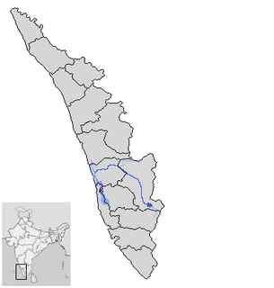
Periyar is the longest river and the river with the largest discharge potential in the Indian state of Kerala. It is one of the few perennial rivers in the region and provides drinking water for several major towns. The Periyar is of utmost significance to the economy of Kerala. It generates a significant proportion of Kerala's electrical power via the Idukki Dam and flows along a region of industrial and commercial activity. The river also provides water for irrigation and domestic use throughout its course besides supporting a rich fishery. Due to these reasons, the river has been named the "Lifeline of Kerala". Kochi city, in the vicinity of the river mouth draws its water supply from Aluva, an upstream site sufficiently free of seawater intrusion. Twenty five percent of Kerala's industries are along the banks of river Periyar. These are mostly crowded within a stretch of 5 kilometres (3 mi) in the Eloor-Edayar region (Udhyogamandal), about 10 kilometres (6 mi) north of Kochi harbor.

Three Rivers Park District is a special park district serving the suburban areas of the Twin Cities including suburban Hennepin, Carver, Dakota, Scott and Ramsey counties. Three Rivers's mission is "To promote environmental stewardship through recreation and education in a natural resources-based park system." Three Rivers operates twenty parks and ten regional trails, with at least two more regional trails planned. Nearly seven million people visit Three Rivers facilities each year.
In 1999, the Guana Tolomato Matanzas National Estuarine Research Reserve was designated in St. Johns and Flagler counties, Florida as a part of the National Oceanic and Atmospheric Administration (NOAA) National Estuarine Research Reserve (NERR) system. The GTM Research Reserve represents the east Florida sub-region of the Carolinian bioregion. It is one of 29 NERRs in 23 states and one territory. GTM is one of three NERRs in Florida, and is administered on behalf of the state by the Florida Department of Environmental Protection's Florida Coastal Office as part of a network that includes forty-one aquatic preserves, three NERRs, a National Marine Sanctuary, the Coral Reef Conservation Program and the Florida Oceans and Coastal Council.
Middleton Lakes RSPB reserve is a 160 hectares nature reserve, formally opened on 19 May 2011, created and run by the Royal Society for the Protection of Birds at Middleton, Warwickshire, England, just south of Tamworth. The Northern part of the reserve lies in Staffordshire, yet the reserve is only a few minutes from the outskirts of Birmingham.
Teslin Lake is a large lake spanning the border between British Columbia and Yukon, Canada. It is one of a group of large lakes in the region of far northwestern BC, east of the upper Alaska Panhandle, which are the southern extremity of the basin of the Yukon River, and which are known in Yukon as "the Southern Lakes". The lake is fed and drained primarily by the Teslin River, south and north, but is also fed from the east by the Jennings River and the Swift River, and from the west by the Hayes River.
Henry River, a perennial stream of the Clarence River catchment, is located in the Northern Tablelands district of New South Wales, Australia.

The Strike-a-Light River, a perennial stream that is part of the Murrumbidgee catchment within the Murray–Darling basin, is located in the Snowy Monaro Regional Council area of New South Wales, Australia.
Yarrow River, a perennial stream of the Clarence River catchment, is located in the Northern Tablelands district of New South Wales, Australia.

The Hudson River National Estuarine Research Reserve is a National Estuarine Research Reserve in the state of New York.
Slocums River is a 4.3-mile-long (6.9 km) tidal river in southeastern Massachusetts in the United States. The Paskamanset River and Slocums River really form just a single river, but the freshwater portion kept its earlier Indian name, while the salt-water portion is named for its English discoverer.

Ojibways of the Pic River First Nation is an Ojibway (Anishinaabe) First Nation reserve on the northern shore of Lake Superior at the mouth of the Pic River. Pic River is not a signatory to the Robinson Superior treaty; however, they did petition, starting in 1879, for a reserve and the request was subsequently granted. The community is located on the 316.6-hectare (782-acre) Pic River 50 Indian reserve. In November 2007, their total registered population was 964 people, of which their on-reserve population was 480.


