This page is based on this
Wikipedia article Text is available under the
CC BY-SA 4.0 license; additional terms may apply.
Images, videos and audio are available under their respective licenses.

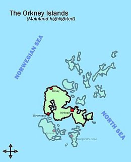
Orkney, also known as the Orkney Islands, is an archipelago in the Northern Isles of Scotland, situated off the north coast of the isle of Great Britain. Orkney is 10 miles (16 km) north of the coast of Caithness and comprises approximately 70 islands, of which 20 are inhabited. The largest island, Mainland, is often referred to as "the Mainland", and has an area of 523 square kilometres (202 sq mi), making it the sixth-largest Scottish island and the tenth-largest island in the British Isles. The largest settlement and administrative centre is Kirkwall.

Hoy is an island in Orkney, Scotland, measuring 143 square kilometres (55 sq mi) — ranked largest in the archipelago after Mainland. A natural causeway, the Ayre, links to much smaller South Walls; the two islands are treated as one entity by the UK census.
The Mainland is the main island of Orkney, Scotland. Both of Orkney's burghs, Kirkwall and Stromness, lie on the island, which is also the heart of Orkney's ferry and air connections.

Flotta is a small island in Orkney, Scotland, lying in Scapa Flow. The island is known for its large oil terminal and is linked by Orkney Ferries to Houton on the Orkney Mainland and Lyness and Longhope on Hoy. The island has a population of 80.
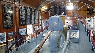
RNLB Thomas McCunn is a 45ft 6in Watson-class lifeboat stationed at Longhope in Orkney, Scotland, from January 1933 until April 1962. During which time she was launched on service 101 times and saved 308 lives. After Thomas McCunn left Longhope she was placed into the reserve fleet for ten years before being sold and used as a pleasure boat. In 2000 she was bought by Longhope Lifeboat Museum. The lifeboat is now at the centre of a display in the old slipway at Brims and is still launched on special occasions.
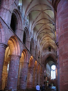
The Bishop of Orkney was the ecclesiastical head of the Diocese of Orkney, one of thirteen medieval bishoprics of Scotland. It included both Orkney and Shetland. It was based for almost all of its history at St Magnus Cathedral, Kirkwall.
Anthony Robert Trickett MBE DL was a Scottish doctor and Lord Lieutenant of Orkney.
Robert Kemp (1908-1967) was a Scottish playwright.

Lyness is a village on the east coast of the island of Hoy, Orkney, Scotland. The village is within the parish of Walls and Flotta, and is situated at the junction of the B9047 and B9048.

Brims is a village at the southern point of the island of Hoy, in Orkney, Scotland. The settlement is within the parish of Walls and Flotta. The RNLI lifeboat Thomas McCunn is on display at the Longhope Lifeboat Museum in Brims.

The A4136 road is the main road through the Forest of Dean in Gloucestershire, England and Monmouthshire, Wales. At its western end it connects to the A466 road at Wyesham, which is a short distance from Wye Bridge and the A40 road at Monmouth. Its eastern end at Huntley, Gloucestershire also connects to the A40. It is 16.5 miles (26.6 km) long, a shortcut of approximately 3.8 miles (6.1 km) relative to the A40.

Hackness Martello Tower and Battery is located on South Walls, in Orkney, Scotland.

Scandinavian Scotland refers to the period from the 8th to the 15th centuries during which Vikings and Norse settlers, mainly Norwegians and to a lesser extent other Scandinavians, and their descendents colonised parts of what is now the periphery of modern Scotland. Viking influence in the area commenced in the late 8th century, and hostility between the Scandinavian Earls of Orkney and the emerging thalassocracy of the Kingdom of the Isles, the rulers of Ireland, Dál Riata and Alba, and intervention by the crown of Norway were recurring themes.
The Crockness Martello Tower on Hoy, Orkney, Scotland, was built at the same time as the Martello Tower at Hackness. It is on the north side of Longhope Sound to the north of Crock Ness point and the hamlet of Crockness, while Hackness is on the south side of the Sound. Crockness tower is currently not open to the public.
Events from the year 1969 in Scotland.

The Cantick Head Lighthouse is an active 19th century lighthouse on the Scottish island of South Walls in the Orkney island. It is located at the end of Cantick Head, a long peninsula on the south-eastern coast of South Walls that overlooks the Pentland Firth and the Sound of Hoxa, which forms the southern entry to the natural harbour of Scapa Flow.
Hoy and West Mainland is a national scenic area (NSA) covering parts of the islands of Hoy and Mainland in the Orkney Islands of Scotland, as well as parts of the surrounding sea. It is one of 40 such areas in Scotland, which are defined so as to identify areas of exceptional scenery and to ensure its protection by restricting certain forms of development. The Hoy and West Mainland NSA covers 24,407 ha in total, consisting of 16,479 ha of land with a further 7928 ha being marine.

