English usually refers to:
Orange usually refers to:
Riverside describes anything on the bank of or alongside a river. It may refer to:
Alpine refers to the Alps, a European mountain range, or to the Alpine states associated with the mountain range.

Sierra County is a county in the U.S. state of California. As of the 2010 census, the population was 3,240 making it California's second-least populous county. The county seat is Downieville, and the only incorporated city is Loyalton. The county is in the Sierra Nevada, northeast of Sacramento on the border with Nevada.

Morcom Township is a township in Saint Louis County, Minnesota, United States. The population was 94 at the 2010 census.
Jericho is a city, populated since ancient times, in the West Bank, Palestine.

In law, an unincorporated area is a region of land that is not governed by a local municipal corporation; similarly an unincorporated community is a settlement that is not governed by its own local municipal corporation, but rather is administered as part of larger administrative divisions, such as a township, parish, borough, county, city, canton, state, province or country. Occasionally, municipalities dissolve or disincorporate, which may happen if they become fiscally insolvent, and services become the responsibility of a higher administration. Widespread unincorporated communities and areas are a distinguishing feature of the United States and Canada. In most other countries of the world, there are either no unincorporated areas at all, or these are very rare; typically remote, outlying, sparsely populated or uninhabited areas.
A census-designated place (CDP) is a concentration of population defined by the United States Census Bureau for statistical purposes only. CDPs have been used in each decennial census since 1980 as the counterparts of incorporated places, such as self-governing cities, towns, and villages, for the purposes of gathering and correlating statistical data. CDPs are populated areas that generally include one officially designated but currently unincorporated small community, for which the CDP is named, plus surrounding inhabited countryside of varying dimensions and, occasionally, other, smaller unincorporated communities as well. CDPs include small rural communities, colonias located along the U.S. border with Mexico, and unincorporated resort and retirement communities and their environs.
New York most commonly refers to:

State Route 49 is a north–south state highway in the U.S. state of California that passes through many historic mining communities of the 1849 California gold rush. Highway 49 is numbered after the "49ers", the waves of immigrants who swept into the area looking for gold, and a portion of it is known as the Gold Country Highway. This roadway begins at Oakhurst, Madera County, in the Sierra Nevada, where it diverges from State Route 41. It continues in a generally northwest direction, weaving through the communities of Goldside and Ahwahnee, before crossing into Mariposa County. State Route 49 then continues northward through the counties of Tuolumne, Calaveras, Amador, El Dorado, Placer, Nevada, Yuba, Sierra, and Plumas, where it reaches its northern terminus at State Route 70, in Vinton.

Agoura is an unincorporated community of Los Angeles County, which is located southeast of the city of Agoura Hills, California, adjacent to the city of Calabasas in Los Angeles County. Agoura was the historical name of the area, before much of the area was developed and before the incorporation of the city of Agoura Hills. There are a few pockets of unincorporated areas, containing a handful of houses, in the area. Much of the area is also often referred to as the neighborhood Old Agoura. The ZIP code is 91301 and the area codes are 747 and 818.
Gheen Corner is an unincorporated community in Saint Louis County, Minnesota, United States.
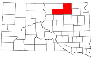
The Aberdeen Micropolitan Statistical Area, as defined by the United States Census Bureau, is an area consisting of two counties in South Dakota, anchored by the city of Aberdeen. As of the 2010 census, the μSA had a population of 40,602.
Schroeder Mountain is a mountain in the California's Sierra Nevada, on the Tahoe National Forest. It is located 0.8 miles (1 km) east of California State Route 49 in Sierra County. Its elevation is 6,942 feet (2,116 m).
The Boca and Loyalton Railroad was built to serve sawmills in the Sierra Nevada of northern California. It became the Loyalton branch of the Western Pacific Railroad.

