Lungga Point

Last updated
Lungga Point
Suburb
Location map Guadalcanal.png
Red pog.svg
Lungga Point
Location in Guadalcanal
Coordinates: 9°26′S159°57′E / 9.433°S 159.950°E / -9.433; 159.950
CountryFlag of the Solomon Islands.svg  Solomon Islands
Province Honiara Town
Island Guadalcanal
Elevation 29 m (95 ft)
Time zone UTC (UTC+11)

Lungga Point is a suburb of Honiara, Solomon Islands and is located East of the main center and North-West of Honiara International Airport .

Honiara Place in Honiara Town, Solomon Islands

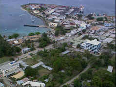
Honiara is the capital city of Solomon Islands, situated on the northwestern coast of Guadalcanal. As of 2017, it had a population of 84,520 people. The city is served by Honiara International Airport and the seaport of Point Cruz, and lies along the Kukum Highway.

Solomon Islands Country in Oceania

Solomon Islands is a sovereign state consisting of six major islands and over 900 smaller islands in Oceania lying to the east of Papua New Guinea and northwest of Vanuatu and covering a land area of 28,400 square kilometres (11,000 sq mi). The country's capital, Honiara, is located on the island of Guadalcanal. The country takes its name from the Solomon Islands archipelago, which is a collection of Melanesian islands that also includes the North Solomon Islands, but excludes outlying islands, such as Rennell and Bellona, and the Santa Cruz Islands.

Honiara International Airport international airport in Honiara, Guadalcanal, Solomon Islands

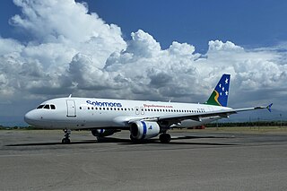
Honiara International Airport, formerly known as Henderson Field, is an airport on Guadalcanal Island in the nation of Solomon Islands. It is the only international airport in the country and is located 8 kilometers from the capital Honiara.

Related Research Articles

Chinatown, Honiara Suburb in Guadalcanal, Honiara Town, Solomon Islands

Chinatown is a suburb of Honiara, Solomon Islands located South East of the main center. It contains the 56-room Honiara Hotel.

Vura, Honiara Suburb in Honiara Town, Solomon Islands

Vura is a suburb in Honiara, Solomon Islands located East of the main center.

Golf Course, Honiara Place in Honiara Town, Solomon Islands

Honiara Golf Course is an actual golf course in the Auki suburb of Honiara, Solomon Islands.

Mbokona Suburb in Honiara Town, Solomon Islands

Mbokona is a suburb of Honiara, Solomon Islands and is located South of the main center.

Tuvaruhu Suburb in Honiara Town, Solomon Islands

Tuvaruhu is a suburb of Honiara, Solomon Islands, south of Point Cruz.

Namoliki Suburb in Honiara Town, Solomon Islands

Namoliki is a suburb of Honiara, Solomon Islands and is located South of Chinatown.

Kolaale Suburb in Honiara Town, Solomon Islands

Kola'ale is a suburb of Honiara, Solomon Islands and is located South of Kukum.

Mount Austen Suburb in Honiara Town, Solomon Islands

Mount Austen is a suburb of Honiara, Solomon Islands and is located South of Kukum.

Gilbert Camp Suburb in Honiara Town, Solomon Islands

Gilbert Camp is a suburb of Honiara, Solomon Islands and is located South of Kukum.

Panatina Suburb in Honiara Town, Solomon Islands

Panatina is a suburb of Honiara, Solomon Islands and is located West of the main center.

Naha, Honiara Suburb in Honiara Town, Solomon Islands

Naha is a suburb of Honiara, Solomon Islands and is located South of Kukum.

Baranaba Suburb in Honiara Town, Solomon Islands

Baranaba is a suburb of Honiara, Solomon Islands and is located South of Ranadi.

Nggeukama Suburb in Honiara Town, Solomon Islands

Nggeukama is a suburb of Honiara, Solomon Islands and is located West of Lungga Point.

King George Creek Suburb in Honiara Town, Solomon Islands

King George Creek is a suburb of Honiara, Solomon Islands and is located South of King George.

Betikama Suburb in Honiara Town, Solomon Islands

Betikama is a suburb of Honiara, Solomon Islands and is located South of Lungga Point.

NZ Camp Suburb in Honiara Town, Solomon Islands

NZ Camp is a suburb of Honiara, Solomon Islands and is located South-East of Honiara International Airport.

Guadacanal Resort Suburb in Honiara Town, Solomon Islands

Guadacanal Resort is a suburb of Honiara, Solomon Islands and is located North of the Honiara International Airport and East of Lungga Point.

Henderson West Suburb in Honiara Town, Solomon Islands

Henderson West is a suburb of Honiara, Solomon Islands and is located West Honiara International Airport.

Henderson Central Suburb in Honiara Town, Solomon Islands

Henderson Central is a suburb of Honiara, Solomon Islands and is located near the Honiara International Airport.

Henderson East Suburb in Honiara Town, Solomon Islands

Henderson East is a suburb of Honiara, Solomon Islands and is located East of Honiara International Airport.

References

    Coordinates: 8°46′S160°42′E / 8.767°S 160.700°E / -8.767; 160.700

    Geographic coordinate system Coordinate system

    A geographic coordinate system is a coordinate system that enables every location on Earth to be specified by a set of numbers, letters or symbols. The coordinates are often chosen such that one of the numbers represents a vertical position and two or three of the numbers represent a horizontal position; alternatively, a geographic position may be expressed in a combined three-dimensional Cartesian vector. A common choice of coordinates is latitude, longitude and elevation. To specify a location on a plane requires a map projection.