El Salvador borders the North Pacific Ocean to the south and southwest, with Guatemala to the north-northwest and Honduras to the north-northeast. In the southeast, the Golfo de Fonseca separates it from Nicaragua. El Salvador is the smallest Central American country and is the only one without a coastline on the Caribbean sea. El Salvador is about the size of Israel and the states of New Jersey and Vermont, but has the population size of Lybia and Lebanon.
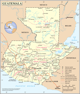
Guatemala is mountainous, except for the south coastal area and the vast northern lowlands of Petén department. Two mountain chains enter Guatemala from west to east, dividing the country into three major regions: the highlands, where the mountains are located; the Pacific coast, south of the mountains; and the Petén region, north of the mountains. These areas vary in climate, elevation, and landscape, providing dramatic contrasts between hot and humid tropical lowlands and highland peaks and valleys.

San Marcos is a department in northwestern Guatemala, on the Pacific Ocean and along the western Guatemala-Mexico border.

A country's Pacific coast is the part of its coast bordering the Pacific Ocean.

Pacaya is an active complex volcano in Guatemala, which first erupted approximately 23,000 years ago and has erupted at least 23 times since the Spanish invasion of Guatemala. Pacaya rises to an elevation of 2,552 metres (8,373 ft). After being dormant for over 70 years, it began erupting vigorously in 1961 and has been erupting frequently since then. Much of its activity is Strombolian, but occasional Plinian eruptions also occur, sometimes showering the area of the nearby Departments with ash.

Puerto San José is a city on Guatemala's Pacific Ocean coast, in the department of Escuintla. It contains about 20,000 people, making it the largest place along the Pacific coast of Guatemala. It was the Pacific port for Guatemala, but this was superseded in the 20th century by Puerto Quetzal, a few kilometers to the east of the town. The Puerto Quetzal complex is the major employer in the town. The local tourist industry caters largely for weekenders from Guatemala City. San José Airport has been refurbished lately and is now the official alternate airport for Guatemala City.

Mazatenango is a municipality in the Suchitepéquez department of Guatemala. It is the capital of Suchitepéquez department and is located 165 km from Guatemala City.

Cotzumalhuapa archaeological culture is from the piedmont area of the Escuintla Department, Guatemala. The Cotzumalhuapa archaeological zone is near the town of Santa Lucía Cotzumalguapa.

The Sierra Madre de Chiapas is a major mountain range in Central America. The Sierra Madre de Chiapas is part of the American Cordillera, a chain of mountain ranges (cordillera) that consists of an almost continuous sequence of mountain ranges that form the western "backbone" of North America, Central America, and South America.
The Central America bioregion is a biogeographic region comprising southern Mexico and Central America.

The Motagua Fault is a major, active left lateral-moving transform fault which cuts across Guatemala, continuing offshore along the southern Pacific coast of Mexico, returning onshore along the southernmost tip of Oaxaca, then continuing offshore until it merges with the Middle America Trench near Acapulco. It forms part of the tectonic boundary between the North American Plate and the Caribbean Plate. It is considered the onshore continuation of the Swan Islands Transform Fault which runs under the Caribbean Sea.
Federal Highway 200, also known as Carretera Pacífico, is a Federal Highway of Mexico. The Carretera Pacífico is the main leg of the Pacific Coastal Highway within Mexico and travels along the Pacific Coast from Mexican Federal Highway 15 in Tepic, Nayarit in the north to the Guatemala-Mexico border at Talismán, Chiapas in the south. Upon entering Guatemala, the highway continues as Central American Highway 1.
Guatemala faces substantial resource and institutional challenges in successfully managing its national water resources. Deforestation is increasing as the global demand for timber exerts pressure on the forests of Guatemala. Soil erosion, runoff, and sedimentation of surface water is a result of deforestation from development of urban centers, agriculture needs, and conflicting land and water use planning. Sectors within industry are also growing and the prevalence of untreated effluents entering waterways and aquifers has grown alongside.
Afro-Guatemalans are Guatemalans of African descent. Afro-Guatemalans comprise 1-2% of the population. They are of mainly English speaking West Indian (Antillean) and Garifuna population. They are found in the Caribbean coast, in Livingston, Puerto Barrios and Santo Tomas. During the colonial period, African slaves were brought in, but have mixed with the general population and can be referred to them as Afro-mestizos. So, due to miscegenation, the majority of black people became in Mulatto and Zambo and these in turn became in Quadroon and Cambujos. Due to centuries of miscegenation, Afro-Guatemalans today form part of the country's mixed race, non-indigenous ladino population.
Manchón is a surname. Notable people with the surname include:
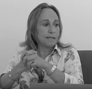
Rosa María Manchón Ruiz is a Spanish linguist. She is currently a professor of applied linguistics at the University of Murcia, Spain. Her research focuses on second language acquisition and second language writing. She was the editor of the Journal of Second Language Writing between 2008 and 2014. Along with Cumming, Hyland, Kormos, Matsuda, Ortega, Polio, Neomy Storch and Verspoor, Manchón is considered an important theoretician in second language writing research.