
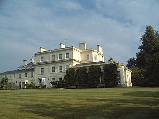
Addington Palace is an 18th-century mansion in Addington near Croydon in south London, England. It was built on the site of a 16th-century manor house. It is particularly known for having been, between 1807 and 1897, the summer residence of the Archbishops of Canterbury. Between 1953 and 1996 it was occupied by the Royal School of Church Music. It is now a conference and wedding venue and country club, while the grounds are occupied by a golf course.

Brookland is a neighborhood located in Ward 5 of Northeast Washington, D.C. right across from the Catholic University of America. Brookland is contained between Michigan Avenue N.E. to the north, the Washington Metropolitan Area Red Line train tracks to the west, South Dakota Avenue N.E. to the east, and Rhode Island Avenue N.E. to the south. The western boundary originates with the establishment of the former Metropolitan Branch of the Baltimore and Ohio Railroad in 1873, which now incorporates the Red Line of the Washington Metro creating the physical barrier which continues to separate Brookland from Edgewood to the west today.

Neath is a constituency represented in the House of Commons of the Parliament of the United Kingdom. It elects one Member of Parliament (MP) by the first past the post system of election and one Assembly Member by the first past the post system of election.

Swansea West is a constituency of the House of Commons of the Parliament of the United Kingdom. It elects one Member of Parliament (MP) by the first past the post system of election, and is currently represented by Geraint Davies of the Labour Co-operative party, who was first elected in the constituency in 2010.
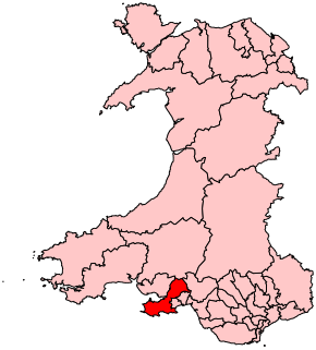
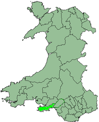
Gower is a constituency created in 1885 represented in the House of Commons of the UK Parliament by one member of parliament (MP). Tonia Antoniazzi, Labour Party became its MP after winning it from a Conservative in the 2017 UK general election. Her party had represented the seat from 1908 until 2015.

Swansea East is a borough constituency represented in the House of Commons of the Parliament of the United Kingdom.
Brantridge Park, Balcombe, West Sussex, England is a 19th-century country house, formerly one of the lesser royal residences.

Llansamlet is the name of an electoral ward in the City and County of Swansea, Wales, UK.
Killay is the name of a suburb and local government community in Swansea, Wales. Killay has its own community council. The village is set high above sea level, about 3.5 miles west of Swansea city centre.
Penllergaer is a village and community in the City and County of Swansea, Wales, falling within the electoral ward of the same name. It is situated about 4.5 miles north west of Swansea city centre, near junction 47 of the M4 motorway.
Singleton Park is the largest urban park in the city of Swansea. It is located in Sketty.

The City and County of Swansea Council is the governing body for one of the Principal Areas of Wales covering Swansea, Gower and the surrounding area. The council consists of 72 councillors representing 36 electoral wards.

Singleton Abbey is a large, mainly 19th century mansion in Swansea, Wales. Today, the buildings are used to house administration offices for Swansea University. They can be found at the eastern end of the Swansea University Singleton Park campus.
The Swansea district was one of the four local government districts of West Glamorgan, Wales, from 1974 to 1996. It was formed from the areas of the county borough of Swansea and Gower Rural District, from the administrative county of Glamorgan.

The Mansion House, located on Richmond Road, is the official residence of the Lord Mayor of Cardiff. Architects Habershon & Fawckner designed the Mansion House and it was built in 1896 for James Howell, owner of Howells department store. It was then known then as 'The Grove'.
Gendros is a suburban district of the City and County of Swansea, Wales falling within the Cockett ward. Gendros approximates to the settlement northwest of Carmarthen Road between Cwmdu and Penlan. Other areas surrounding Gendros are Blaen-y-Maes, Ravenhill, Cwmbwrla, Cockett, Fforestfach and Mayhill and Townhill. Its post code begins with SA5.

Foresthall House was a mansion like house that existed on the site of the Swansea suburb of Fforestfach until the 1970s when the old and crumbling mansion was bought by Swansea council and demolished in order to make way for various new estates.

The Mansion House was the official residence of the Mayor of Newport, South Wales until 2009. In addition to being the Mayor's official residence, it also offered hospitality and accommodation to official visitors to the city from overseas.
South Cornelly is a village in Cornelly, Bridgend county borough, Wales. The village is close to North Cornelly, Pyle and Porthcawl, and junction 37 of the M4 motorway, which runs along its northern side. It is in the historic county of Glamorgan.

Swansea Victoria is a former railway station in Swansea, south Wales, opened to passenger and goods traffic on 14 December 1867. Owned successively by the Llanelly Railway and Dock Company, the Swansea and Carmarthen Railways Company, the London and North Western Railway Company, the London, Midland and Scottish Railway Company and British Railways, it was served by trains to and from Shrewsbury, Crewe, Liverpool, Manchester and York and formed the southern terminus of the Central Wales line, most of which is still operational as the Heart of Wales Line. Victoria closed in June 1964, having been listed in the Report on the Reshaping of British Railways the previous year. The site was subsequently cleared and used for Swansea Leisure Centre.


