
WordStar is a discontinued word processor application for microcomputers. It was published by MicroPro International and originally written for the CP/M-80 operating system, with later editions added for MS-DOS and other 16-bit PC OSes. Rob Barnaby was the sole author of the early versions of the program.

Microsoft Paint is a simple raster graphics editor that has been included with all versions of Microsoft Windows. The program opens, modifies and saves image files in Windows bitmap (BMP), JPEG, GIF, PNG, and single-page TIFF formats. The program can be in color mode or two-color black-and-white, but there is no grayscale mode. For its simplicity and wide availability, it rapidly became one of the most used Windows applications, introducing many to painting on a computer for the first time.

In the maintenance of file systems, defragmentation is a process that reduces the degree of fragmentation. It does this by physically organizing the contents of the mass storage device used to store files into the smallest number of contiguous regions. It also attempts to create larger regions of free space using compaction to impede the return of fragmentation. Some defragmentation utilities try to keep smaller files within a single directory together, as they are often accessed in sequence.

File Explorer, previously known as Windows Explorer, is a file manager application and default desktop environment that is included with releases of the Microsoft Windows operating system from Windows 95 onwards. It provides a graphical user interface for accessing the file systems, as well as user interface elements such as the taskbar and desktop.
Btrieve is a transactional database software product. It is based on Indexed Sequential Access Method (ISAM), which is a way of storing data for fast retrieval. There have been several versions of the product for DOS, Linux, older versions of Microsoft Windows, 32-bit IBM OS/2 and for Novell NetWare.

WinRAR is a trialware file archiver utility, developed by Eugene Roshal of win.rar GmbH. It can create and view archives in RAR or ZIP file formats, and unpack numerous archive file formats. To enable the user to test the integrity of archives, WinRAR embeds CRC32 or BLAKE2 checksums for each file in each archive. WinRAR supports creating encrypted, multi-part and self-extracting archives.

In computing, a file system or filesystem governs file organization and access. A local file system is a capability of an operating system that services the applications running on the same computer. A distributed file system is a protocol that provides file access between networked computers.
Btrieve is a database developed by Pervasive Software. The architecture of Btrieve has been designed with record management in mind. This means that Btrieve only deals with the underlying record creation, data retrieval, record updating and data deletion primitives. Together with the MicroKernel Database Engine it uses ISAM, Indexed Sequential Access Method, as its underlying storage mechanism.
Microsoft WinHelp is a proprietary format for online help files that can be displayed by the Microsoft Help browser winhelp.exe or winhlp32.exe. The file format is based on Rich Text Format (RTF). It remained a popular Help platform from Windows 3.0 through Windows XP. WinHelp was removed in Windows Vista purportedly to discourage software developers from using the obsolete format and encourage use of newer help formats. Support for WinHelp files would eventually be removed entirely in Windows 10.
Extensible Storage Engine (ESE), also known as JET Blue, is an ISAM data storage technology from Microsoft. ESE is the core of Microsoft Exchange Server, Active Directory, and Windows Search. It is also used by a number of Windows components including Windows Update client and Help and Support Center. Its purpose is to allow applications to store and retrieve data via indexed and sequential access.
On Microsoft Windows operating systems, starting with the Internet Explorer 4 Active Desktop Update for Windows 95 to 98, a thumbnail cache is used to store thumbnail images for Windows Explorer's thumbnail view. This speeds up the display of images as these smaller images do not need to be recalculated every time the user views the folder.
As the next version of Windows NT after Windows 2000, as well as the successor to Windows Me, Windows XP introduced many new features but it also removed some others.
The Windows Imaging Format (WIM) is a file-based disk image format. It was developed by Microsoft to help deploy Windows Vista and subsequent versions of the Windows operating system family, as well as Windows Fundamentals for Legacy PCs.
Compared with previous versions of Microsoft Windows, features new to Windows Vista are numerous, covering most aspects of the operating system, including additional management features, new aspects of security and safety, new I/O technologies, new networking features, and new technical features. Windows Vista also removed some others.
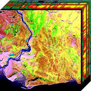
Hyperspectral imaging collects and processes information from across the electromagnetic spectrum. The goal of hyperspectral imaging is to obtain the spectrum for each pixel in the image of a scene, with the purpose of finding objects, identifying materials, or detecting processes. There are three general types of spectral imagers. There are push broom scanners and the related whisk broom scanners, which read images over time, band sequential scanners, which acquire images of an area at different wavelengths, and snapshot hyperspectral imagers, which uses a staring array to generate an image in an instant.
Windows Vista has many significant new features compared with previous Microsoft Windows versions, covering most aspects of the operating system.
Windows Vista contains a range of new technologies and features that are intended to help network administrators and power users better manage their systems. Notable changes include a complete replacement of both the Windows Setup and the Windows startup processes, completely rewritten deployment mechanisms, new diagnostic and health monitoring tools such as random access memory diagnostic program, support for per-application Remote Desktop sessions, a completely new Task Scheduler, and a range of new Group Policy settings covering many of the features new to Windows Vista. Subsystem for UNIX Applications, which provides a POSIX-compatible environment is also introduced.
Dragon is a remote sensing image processing software package. This software provides capabilities for displaying, analyzing, and interpreting digital images from earth satellites and raster data files that represent spatially distributed data. All the Dragon packages are derived from the code created by Goldin-Rudahl.