The meadow pipit is a small passerine bird which breeds in much of northwestern Eurasia, from southeastern Greenland and Iceland east to just east of the Ural Mountains in Russia, and south to central France and Romania; there is also an isolated population in the Caucasus Mountains. It is migratory over most of its range, wintering in southern Europe, North Africa and south-western Asia, but is resident year-round in western Europe. However, even here, many birds move to the coast or lowlands in winter.

Moorland or moor is a type of habitat found in upland areas in temperate grasslands, savannas, and shrublands and montane grasslands and shrublands biomes, characterised by low-growing vegetation on acidic soils. Moorland nowadays generally means uncultivated hill land, but includes low-lying wetlands. It is closely related to heath although experts disagree on precisely what distinguishes the types of vegetation. Generally, moor refers to highland, high rainfall zones, whereas heath refers to lowland zones which are more likely to be the result of human activity.
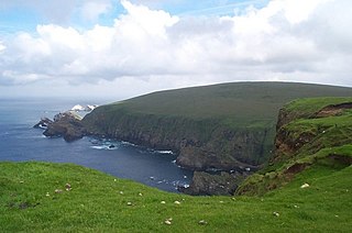
Hermaness is the northernmost headland of Unst, the most northerly inhabited island of Shetland, Scotland. It consists of huge sea cliffs and moorland, making it an ideal habitat for a variety of birds. Hermaness was designated a national nature reserve (NNR) in 1955. The NNR extends over 965 hectares, including the whole of the Hermaness peninsula and the outlying Muckle Flugga and Out Stack. The reserve includes a visitor centre at Burrafirth, in the old lighthouse shore station, as well as a boardwalk that extends out onto the moorland. The reserve is managed by Scottish Natural Heritage, though it remains in private ownership, with most being owned by the Buness Estate, although the stacks and skerries around Muckle Flugga are owned by the Northern Lighthouse Board.

Ben Wyvis is a mountain located in Easter Ross, north-west of Dingwall in northern Scotland. It lies in the council area of Highland, and the county of Ross and Cromarty. The mountain is prominent in views of the area, presenting a whale-back shape above the farmland of Strathconon. Geologically, the ridge is composed of Moine pelitic gneiss.
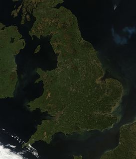
England comprises most of the central and southern two-thirds of the island of Great Britain, in addition to a number of small islands of which the largest is the Isle of Wight. England is bordered to the north by Scotland and to the west by Wales. It is closer to continental Europe than any other part of mainland Britain, divided from France only by a 33 km (21 mi) sea gap, the English Channel. The 50 km (31 mi) Channel Tunnel, near Folkestone, directly links England to mainland Europe. The English/French border is halfway along the tunnel.

The Rinns of Islay is an area on the west of the island of Islay in the Inner Hebrides of Scotland.
Gleniffer Braes is a short range of hills and park area to the south of Paisley, Scotland which form the boundary of Renfrewshire and North Ayrshire.

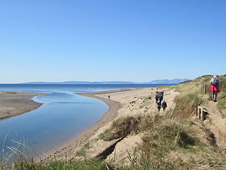
The Ythan Estuary is the tidal component of the Ythan River, emptying into the North Sea 19 kilometres (12 mi) north of Aberdeen, Scotland. The estuary’s tidal action extends a 7 kilometres (4.3 mi) inland and has characteristic widths of between 250 metres (820 ft) and 780 metres (2,560 ft). Besides the tidal channel there are interfaces to the upland dunes including mudflats, sand beaches and shingle flats. Reaches of salt marsh occur, but they are primarily near the Waterside Bridge and the mouth of the Tarty Burn, a small tributary river. Based upon the habitat of the moorland bordering the east of the Ythan River near the mouth, this estuary is the most significant coastal moorland in the northern United Kingdom.
Beinn Dearg is a mountain in the Inverlael area of the Highlands of Scotland. It is most frequently climbed by following the River Lael up Gleann na Sguaib. Starting from near the head of Loch Broom, a path follows the glen to a bealach, which is about a kilometre north of the summit. From this bealach, the neighbouring peaks of Con a' Mheall and Meall na Ceapraichean may also be climbed. Eididh nan Clach Geala, which lies about 3 km north of Beinn Dearg, is also added in to complete a round of 4 Munros.

Muirkirk is a small village in East Ayrshire, southwest Scotland. It is located on the north bank of the River Ayr, between Cumnock and Glenbuck on the A70.
Waterbird Regional Preserve is a 192 acres (0.78 km2) regional park located in Contra Costa County, California, adjacent to the city of Martinez, CA. It is part of the East Bay Regional Park District (EBRPD). It primarily consists of an area known as McNabney Marsh, which lies alongside Interstate 680 near the Sacramento-San Joaquin Delta and between two large and active oil refineries. The marsh drains into Suisun Bay via Peyton Slough. The area provides habitat for a wide variety of waterfowl and shorebirds for resting and feeding.

Cairnsmore of Fleet is a mountain in the Scottish Lowlands, on the edge of the Galloway Forest Park. The mountain forms an unafforested granite massif, whose highest point is about 10 kilometres (6.2 mi) east of Newton Stewart. It is the highest of the "Solway Hills", and the southernmost of Scotland's 219 Grahams. The view to the south takes in the Cree Estuary and Wigtown Bay, and extends as far as the Lake District, the Isle of Man and Snowdonia. The highest summits of the Galloway Hills can be seen to the north, and Ireland is in the view to the west.
Lugar is a small village in East Ayrshire, southwest Scotland. Lugar is in Auchinleck Parish, Kyle District, Ayrshire. It is 1.5 miles (2.4 km) ENE of Cumnock, and about 1-mile (1.6 km) from Cronberry and 2 miles (3.2 km) from Gasswater. Lugar is a station on the Mauchline and Muirkirk branch of the Glasgow and South Western Railway. Lugar is about 16.5 miles (26.6 km) SE of Kilmarnock.

Hill farming is extensive farming in upland areas, primarily rearing sheep, although historically cattle were often reared extensively in upland areas. Fell farming is the farming of fells, a fell being an area of uncultivated high ground used as common grazing. It is a term commonly used in Northern England, especially in the Lake District and the Pennine Dales. Elsewhere, the terms hill farming or pastoral farming are more commonly used.
The Pow Burn is a long burn located in South Ayrshire, Scotland. The name 'Pow or 'Poll' refers to a slow-moving ditch-like stream.
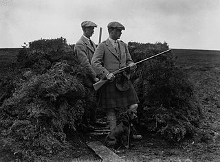
Driven grouse shooting is the hunting of the red grouse, a field sport of the United Kingdom. It is popular because it provides a challenge due to the rapid flight of the grouse. The grouse shooting season extends from 12 August, often called the "Glorious Twelfth", to 10 December each year. Shooting takes place on grouse moors, areas of moorland in northern England and Scotland.

Cotherstone Moor is a Site of Special Scientific Interest in the Teesdale district in south-west County Durham, England. It is an extensive area of moorland which extends almost the entire length of Baldersdale, from the confluence of the River Balder with the Tees at Cotherstone. It runs parallel to Bowes Moor SSSI, which lies a short distance to the south.

Muggleswick, Stanhope and Edmundbyers Commons and Blanchland Moor is a Site of Special Scientific Interest in County Durham and Northumberland, England. It consists of two separate areas, the larger—encompassing the upland areas of Muggleswick, Stanhope and Edmundbyers Commons—in the Derwentside and Wear Valley districts of north Durham, the smaller—Blanchland Moor—in the Tynedale district of south-west Northumberland.

Allendale Moors is a Site of Special Scientific Interest (SSSI) in Northumberland, England. The upland moorland ridge site is listed for its heath, flush and upland grassland which provide a habitat for a nationally important assemblage of moorland breeding birds.

Situated in south-west Scotland, the Silver Flowe-Merrick Kells biosphere reserve is composed of two separate sites.