Transport in Tanzania includes road, rail, air and maritime networks. The road network is 86,472 kilometres (53,731 mi) long, of which 12,786 kilometres (7,945 mi) is classified as trunk road and 21,105 kilometres (13,114 mi) as regional road. The rail network consists of 3,682 kilometres (2,288 mi) of track. Commuter rail service is in Dar es Salaam only. There are 28 airports, with Julius Nyerere International being the largest and the busiest. Ferries connect Mainland Tanzania with the islands of Zanzibar. Several other ferries are active on the countries' rivers and lakes.

Bunda is one of the seven districts of Mara Region in the United Republic of Tanzania, East Africa. It is bordered to the North by the Musoma Rural District and Butiama District, to the east by Serengeti District, to the South by Bariadi District and Busega District, and to the west by Lake Victoria. The district administration town is also called Bunda, located on the north-south trans-national all tarmac highway from Kenya to Zambia via Tarime and the lakeside municipalities of Musoma, Mwanza, and thereon to Mbeya in southern Tanzania. The district has four divisions, namely: Kenkombyo, Nansimo, Serengeti and Chamuriho.

Arusha Region is one of Tanzania's 31 administrative regions. Its capital and largest city is the city of Arusha. The region is bordered by Kajiado County and Narok County in Kenya to the north, the Kilimanjaro Region to the east, the Manyara and Singida regions to the south, and the Mara and Simiyu regions to the west. Major towns include Monduli, Namanga, Longido, and Loliondo to the north, Mto wa Mbu and Karatu to the west, and Usa River to the east. The region is comparable in size to the combined land and water areas of the United States state of Maryland.

Tarime District is one of the seven districts of the Mara Region of Tanzania, East Africa. It was previously known as the "North Mara District". Its administrative seat is Tarime town. It is bordered from the north to east by the Kenyan districts of Migori, Trans Mara and Kisii, and to the east by the Maasai Mara game reserve. To the south it is bordered across the Mara River by the Serengeti and Butiama districts, and to the west by Rorya District.

Arusha Urban District is one of the seven districts of the Arusha Region of Tanzania, and it contains the regional and economic capital; the city of Arusha. It is bordered to the south, west and north by Arusha Rural District and to east by Meru District. As of 1994, Arusha District was the wealthiest district in Tanzania with 91,024 Tanzanian shillings.
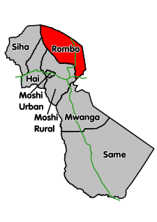
Rombo District is one of the seven districts of the Kilimanjaro Region of Tanzania. It is bordered to the north and east by Kenya, to the west by the Siha District and Hai District, and to the south by the Moshi Rural District.

Mwanga is one of the seven districts of the Kilimanjaro Region of Tanzania. It is bordered to the northeast by Kenya, to the northwest by the Moshi Rural District, to the southwest by the Manyara Region, and to the south by the Same District. Its administrative seat is the town of Mwanga.

Muheza is one of the eight districts of Tanga Region in Tanzania. It is bordered to the north by Kenya, to the east by the Tanga and the Indian Ocean, to the south by the Pangani District, and to the west by the Lushoto and Korogwe Districts.
Kajiado is a town in Kajiado County, Kenya. The town is located 80 km (49.7 mi) south of Nairobi, along the Nairobi – Arusha highway. Kajiado has an urban population of 8128 Local people are predominantly of the Maasai tribe.
Those interested in the subject can monitor changes to the pages by clicking on Related changes in the sidebar. Articles related to Tanzania include:

Migori County is a county in the former Nyanza Province of southwestern Kenya. Migori County is located in western Kenya and borders Homa Bay County (North), Kisii County, Narok, Tanzania and Lake Victoria to the West. The county also borders Uganda via Migingo Island in Lake Victoria. The capital is Migori town, which is also its largest town. The population of Migori County according to the 2009 population census was 917,170. Migori County is located in the sugar belt wetlands of Western Kenya and is mostly at the heart of the African tropics. However, the county enjoys a pleasant climate because of high altitude and the breeze from Lake Victoria.
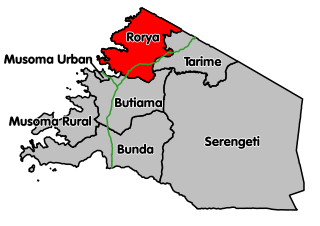
Rorya District is a district in Mara Region, United Republic of Tanzania. The district capital is the village of Ingri Juu, while the largest town is Shirati. The district was created in 2007 from a part of Tarime District. It is bordered by Tarime District to the east, Butiama District to the south, Lake Victoria to the west, and the Republic of Kenya to the north. The majority of inhabitants are from the Luo tribe. Other ethnic groups are Kurya, Kine, Simbiti,Sweta, Hacha, and Suba.
The Tanzania Atomic Energy Commission (TAEC) is a regulatory and service parastatal organization of Tanzania, operating under the mandate of the Ministry of Education, Science and Technology. Offices are located in Njiro Area, Arusha and has zonal offices in Namanga, Dar es Salaam and Zanzibar.

The Ol Donyo Orok mountain, also called Namanga Hills, is situated in southern Kenya next to the Tanzanian border in the Namanga Division. The mountain has a stretched triangular shape, almost like an arrow pointing north. The short side faces the Tanzanian border. The highest peak is 2548 m.

Thika Road is an 8-lane controlled-access highway in Kenya, linking the capital city of Nairobi with the industrial town of Thika. The Thika Road forms 50 km of the A2 Highway, which links Namanga at the Tanzania-Kenya border to the Kenya-Ethiopia border town of Moyale.
The Isinya–Singida High Voltage Power Line is a high voltage electricity power line, under construction, connecting the high voltage substation at Isinya, Kenya to another high voltage substation at Singida, Tanzania.
