
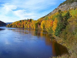
Labrador is a geographic and cultural region within the Canadian province of Newfoundland and Labrador. It comprises the mainland portion of the province, separated from the island of Newfoundland by the Strait of Belle Isle. It is the largest and northernmost geographical region in Atlantic Canada.

Clarenville is a town on the east coast of Newfoundland in the province of Newfoundland and Labrador, Canada. Clarenville was incorporated in 1951 and is located in the Shoal Harbour valley fronting an arm of the Atlantic Ocean called Random Sound.
Bishop's Falls is a town in the north-central part of the island of Newfoundland in the Canadian province of Newfoundland and Labrador, with a population of 3,341 at the 2011 census.
North River may refer to:

The Bay of Islands is an extensive inlet located on the west coast of the island of Newfoundland, in Canada. The Way Office was established on July 1, 1883. The first Waymaster was Thomas Carter. The largest island in the bay is Woods Island. It is surrounded in most directions by the Long Range Mountains and it is directly north of the Lewis Hills.

Nunatsiavut is an autonomous area claimed by the Inuit in Newfoundland and Labrador, Canada. The settlement area includes territory in Labrador extending to the Quebec border. In 2002, the Labrador Inuit Association submitted a proposal for limited autonomy to the government of Newfoundland and Labrador. The constitution was ratified on 1 December 2005, at which time the Labrador Inuit Association ceased to exist, and the new Government of Nunatsiavut was established, initially being responsible for health, education and cultural affairs. It is also responsible for setting and conducting elections, the first of which was executed in October 2006. An election for the Ordinary Members of the Nunatsiavut Assembly was held on 4 May 2010. The Nunatsiavut Assembly was dissolved on 6 April in preparation for the election. Its incumbent president is Johannes Lampe who assumed office in 2016.

Lake Melville is a saltwater tidal extension of Hamilton Inlet on the Labrador coast in the Canadian province of Newfoundland and Labrador. Comprising 3,069 square kilometres, and stretching 140 kilometres inland to Happy Valley-Goose Bay, it forms part of the largest estuary in the province, primarily draining the Churchill River and Naskaupi River watersheds. Both Lake Melville and Hamilton Inlet are encircled by mountains, with primary settlements at Happy Valley-Goose Bay, North West River, and Sheshatshiu. A ferry service runs on Lake Melville and Hamilton Inlet, connecting a number communities including Happy Valley-Goose Bay, Rigolet and Cartwright. Lake Melville was named for Viscount Melville (1742–1811), a prominent British politician.

Nain or Naina is the northernmost permanent settlement in the Canadian province of Newfoundland and Labrador, located about 370 kilometres (230 mi) by air from Happy Valley-Goose Bay. The town was established as a Moravian mission in 1771 by Jens Haven and other missionaries. As of 2011, the population is 1,424 mostly Inuit and mixed Inuit-European.

The Newfoundland Railway was a railway which operated on the island of Newfoundland from 1898 to 1988. With a total track length of 906 miles (1,458 km), it was the longest 3 ft 6 in narrow-gauge railway system in North America.

Placentia—St. Mary's is a provincial electoral district for the House of Assembly of Newfoundland and Labrador, Canada. As of 2011, there were 7,361 eligible voters living within the district.

Burgeo-La Poile is a provincial electoral district for the House of Assembly of Newfoundland and Labrador, Canada. As of 2011, there are 7,527 eligible voters living within the district. The district was first created in 1995 following a reduction in the number of seats in the House of Assembly from 52 to 48, forming from the amalgamation of the former districts of La Poile and Burgeo-Bay D'Espoir.

Happy Valley-Goose Bay is a town in the province of Newfoundland and Labrador, Canada.
St. George's Bay - informally referred to as Bay St. George due to its French translation Baie St-George - is a large Canadian bay in the province of Newfoundland and Labrador. It is located on the west coast of the island of Newfoundland and comprises a sub-basin of the Gulf of St. Lawrence.

Sheshatshiu is an Innu Federal Reserve in the Canadian province of Newfoundland and Labrador, located approximately 30 kilometres north of Goose Bay.
Aillik was a settlement located north of Makkovik, Labrador. The first postmaster was John Pilgrim. The community is named after the bay in which it is located. Aillik is an Inuit term meaning "a place having sleeves", so named because the bay is shaped with two branches at its head. There is also an island which takes its name from the bay.
St. Mary's Bay is one of many bays in Newfoundland, Canada, where bay is taken as a regional subdivision, somewhat along the lines of county divisions. It is the most southern and eastern of Newfoundland's major bays.
Newfoundland is a large Canadian island off the east coast of the North American mainland, and the most populous part of the Canadian province of Newfoundland and Labrador. It has 29 percent of the province's land area. The island is separated from the Labrador Peninsula by the Strait of Belle Isle and from Cape Breton Island by the Cabot Strait. It blocks the mouth of the Saint Lawrence River, creating the Gulf of Saint Lawrence, the world's largest estuary. Newfoundland's nearest neighbour is the French overseas community of Saint-Pierre and Miquelon.
NunatuKavut is an unrecognized Inuit territory in Labrador. The NunatuKavut people are the direct descendants of the Inuit that lived south of the Churchill or Grand River prior to European contact, with European influence from Basque and French whalers.


