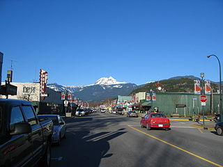
Squamish is a community and a district municipality in the Canadian province of British Columbia, located at the north end of Howe Sound on the Sea to Sky Highway. The population of the Squamish census agglomeration – including First Nation reserves of the Squamish Nation not governed by the municipality – is 19,893.
Paradise Valley may refer to:

Garibaldi Provincial Park, also called Garibaldi Park, is a wilderness park located in British Columbia, Canada, about 70 kilometres (43.5 mi) north of Vancouver. The park is located to the east of the Sea to Sky Highway between Squamish and Whistler and covers an area of over 1,950 square kilometres. Garibaldi was designated as a provincial park in 1927, and originally included what was later split off in 1967 as Golden Ears Provincial Park, which juts southward between the basins of Pitt Lake and the Stave River into the Municipality of Maple Ridge.

The Garibaldi Ranges are the next-to-southwesternmost subdivision of the Pacific Ranges of the Coast Mountains; only the North Shore Mountains are farther southwest. They lie between the valley formed by the pass between the Cheakamus River and Green River on the west and the valley of the Lillooet River on the east, and extend south into Maple Ridge, an eastern suburb of Vancouver, and the northern District of Mission. To their south are the North Shore Mountains overlooking Vancouver while to their southeast are the Douglas Ranges.
Brackendale Eagles Provincial Park is a provincial park in British Columbia, Canada, located on the Squamish River adjacent to Brackendale, a suburban neighbourhood of Squamish.

Brandywine Falls Provincial Park is a provincial park in British Columbia, Canada, located adjacent to BC Highway 99 between Garibaldi and Whistler, British Columbia. It is managed by Sea to Sky Parks for BC Parks.
The Sea-to-Sky Corridor, often referred to as the Corridor, or the Sea to Sky Country, is a region in British Columbia spreading from Horseshoe Bay through Whistler to the Pemberton Valley and sometimes beyond to include Birken and D'Arcy. From Whistler on up, the region overlaps with the older and more historic Lillooet Country, of which Squamish, at the region's centre, was once the southward extension in the days when it was the rail-port terminus from the Interior, via Lillooet, and accessible from the Lower Mainland only by sea. Most of the region is in the Squamish-Lillooet Regional District, although south of Brittania Beach a small part of the region is in the Greater Vancouver Regional District.
The Callaghan Valley is located in the Sea to Sky Country of southwestern, British Columbia, in the Pacific Ranges of the Coast Mountains 90 km north of Vancouver. It was the home of the 2010 Winter Olympics's Whistler Olympic Park, the venue for the Nordic events of the Olympics, and adventure tourism operations including Canadian Wilderness Adventures.

Wedge Mountain, 2895 m (9497 ft) prominence: 2249 m, often locally referred to as The Wedge or simply "Wedge", is the highest summit in the Garibaldi Ranges and therefore also Garibaldi Provincial Park, and is among the nearest of the many peaks visible from the Whistler Blackcomb Ski Area, lying north across the valley of Billygoat Pass from the Spearhead Range, which includes one of that resort's two flagship mountains, Blackcomb. It was named for its distinctive wedge shape by the Garibaldi Park Board in 1932 in preference to Mount Vancouver, which had been submitted earlier. It is part of an unnamed range forming the most northerly group of peaks in the Garibaldi Ranges, the other two most notable being Mount Weart, known as the Armchair because of its shape, and Mount Currie, which overlooks the First Nations Reserve of the same name and the neighbouring town of Pemberton. Wedge's very high prominence is defined by the divide between the Green and Cheakamus Rivers at a locality at the south end of Alta Lake known as Tokum Corners.
Chiyakmesh is a community of the Indigenous Squamish people, located near Squamish, British Columbia. The name of the Cheakamus River comes from the name of this community, which is located on Cheakamus Indian Reserve No. 11. Chiyakamesh translates into People of the Fish Weir. A chiyak is a special fish weir this community used on the Cheakamus River to catch salmon. It is the largest reserve of the Squamish Nation in size.
Green Lake is the largest and most northerly lake in the Resort Municipality of Whistler, British Columbia, Canada. It is the source of the Green River, a tributary of the Lillooet River, and is fed by the River of Golden Dreams, which issues from Alta Lake, which is at the height of land dividing the Green River drainage from that of the Cheakamus River to the south, which is a tributary of the Squamish River. Also feeding Green Lake are Fitzsimmons Creek, which originates in the valley above Whistler Village between Blackcomb and Whistler Mountains, and Rainbow Creek, which descends from Rainbow Mountain via the Alpine Meadows subdivision. A former minor ski hill, Rainbow, is located midway between Alpine Meadows and Emerald Estates near the lake's western extremity.
Daisy Lake, also referred to as Daisy Lake Reservoir, is a reservoir on the Cheakamus River in the Sea to Sky Corridor of southwestern British Columbia, Canada, just south of the Resort Municipality of Whistler and immediately north of the abandoned townsite of Garibaldi.
Brandywine Creek, also formerly known as the Long John River after a local prospector and trapper, is a tributary of the Cheakamus River in the Pacific Ranges of the Coast Mountains in British Columbia, Canada, entering that stream via Daisy Lake, just below Brandywine Falls. The creek is about 14 km in length and originates on the south slope of Brandywine Mountain in Brandywine Meadows, at the southern end of the Powder Mountain Icefield and is the next basin immediately southwest of that of the Callaghan Valley, the site of the Nordic events facility for the 2010 Olympics. The creek's valley has been partially logged. An unnamed hot spring lies in its upper reaches, near Mount Fee.
The Fitzsimmons Range is a small mountain range on the northwestern edge of the Garibaldi Ranges in southwestern British Columbia, Canada, located between the valleys of Cheakamus Lake (SW) and Fitzsimmons Creek (NE). Its most famous summit is Whistler Mountain, which overlooks the resort town of Whistler and is one of the two mountains forming the Whistler Blackcomb ski resort. Most of the range is within Garibaldi Provincial Park, while its northeastern extremity is part of the resort municipality, and of the lands associated with the ski resort operation. Other summits in the range include Oboe Summit, Piccolo Summit and Flute Summit, which are hillocks along the ridge running southeast from Whistler Mountain and were named in association with the renaming of Whistler. Beyond them is Singing Pass and Mount Fitzsimmons 2603 m (8540 ft) which is at the opposite end of the range from Whistler Mountain and the location of Fitzsimmons Glacier, which is the source of Fitzsimmons Creek.
The Cheakamus Valley basalts are a sequence of basaltic lava flows along the Cheakamus River in southwestern British Columbia, Canada. They are part of the Garibaldi section of the Cascade Volcanic Arc and were produced during an episode of volcanic eruptions from an unknown vent. The latest basaltic eruption deposited wood in lacustrine sediments under the lava flows that have been dated 34,200 ± 800 years old. These youngest lavas form isolated ridges above the older glaciated Cheakamus Valley basalts and were described as "esker-like" by Canadian volcanologist Bill Mathews.

Mamquam Mountain is a mountain in the Pacific Ranges of the Coast Mountains in southwestern British Columbia, Canada, located 6 km (3.7 mi) southeast of Eanastick Meadows and 22 km (14 mi) east of Brackendale. It represents the highest summit of the Mamquam Icefield and lies at the southern end of Garibaldi Provincial Park. Mamquam Mountain was named on September 2, 1930 in association with the Mamquam River.

Cheekye is an unincorporated locality on the Cheakamus River just upstream from its confluence with its parent stream, the Squamish, and just north of Brackendale, British Columbia, which is part of the District of Squamish, British Columbia, Canada.


