This page is based on this
Wikipedia article Text is available under the
CC BY-SA 4.0 license; additional terms may apply.
Images, videos and audio are available under their respective licenses.

Pentrebane is a district in the west of Cardiff, capital of Wales. It is part of the Fairwater community.
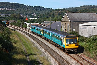
The Rhondda line is a commuter railway line in South Wales from Cardiff to Treherbert. The line follows the Merthyr line as far as Pontypridd, where it then diverges to continue along the Rhondda Valley.

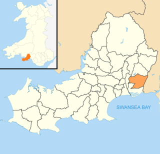
Llansamlet is the name of an electoral ward in the City and County of Swansea, Wales, UK.

The River Rhondda is a river in South Wales with two major tributaries, Rhondda Fawr and Rhondda Fach.

Abenbury is a local government community, the lowest tier of local government, part of the Wrexham County Borough in Wales. It is situated south-east of Wrexham town and includes the village of Pentre Maelor and part of the Wrexham Industrial Estate.

Eastbrook railway station is a railway station serving the Eastbrook area of Dinas Powys, a village near Cardiff, South Wales. It is located on Network Rail's Barry Branch 3½ miles (5 km) south of Cardiff Central towards Barry Island and Bridgend.
Neath Port Talbot College (NPTC) was a further education institution established as two campuses in Port Talbot and Neath in Wales, United Kingdom.
National Cycle Network, Route 43 is part of the National Cycle Network and the Celtic Trail, which connects Swansea with Builth Wells. Most of the route is still awaiting development. As of June 2006, there is a 13-mile section out of Swansea that is open and signed.

World's End is a narrow vale located between Wrexham and Llangollen in Denbighshire, Wales. It lies at the head of the Eglwyseg Valley, enclosed by the cliffs of Craig y Forwyn, Craig y Cythraul, and Craig yr Adar.

The River Artro is a river in Gwynedd, Wales.

Pentre Berw is a small village located on the island of Anglesey in north Wales. It lies about 2 miles (3.2 km) south of the county town of Llangefni.

Bon-y-maen is the name of an electoral ward, a community and a village in the City and County of Swansea, Wales, UK.
Abercanaid railway station served the village of Abercanaid, near Merthyr Tydfil in Wales. Opened by the Quakers Yard & Merthyr Railway, a joint Great Western Railway / Rhymney Railway Joint operation, it became part of the Great Western Railway during the Grouping of 1923. Passing on to the Western Region of British Railways on nationalisation in 1948, it was closed by them three years later.

Morganstown is a part of the community of Radyr and Morganstown in the north of Cardiff, just over 5 miles (8 km) northwest of Cardiff city centre and separated from Radyr to the south by the M4 motorway. It elects four councillors to the Radyr and Morganstown community council.
Llywel is a small village located on the A40, about 4 miles (6.4 km) west of Sennybridge in Powys, Wales. The Afon Gwydderig runs through the village, not far from its source. Llywel also gives its name to a community. The main settlement in the community is Trecastle. According to the 2001 Census the population of Llywel community is 524, falling to 497 at the 2011 Census.
Tŷ Canol National Nature Reserve is a national nature reserve which lies south of the village of Felindre Farchog, Pembrokeshire, Wales, between the Preseli Mountains and the north Pembrokeshire coast.

Pentre Broughton is a small, formerly industrial village in the community of Broughton in Wrexham county borough, Wales. It is contiguous with the neighbouring villages of Moss and Brynteg.
Hebron, Ton Pentre was one of the largest Baptist churches in the Rhondda valleys during their industrial heyday. As membership increased the chapel was rebuilt in 1889 and a schoolroom added in 1908.