Aconcagua, with a summit elevation of 6,960.8 metres (22,837 ft), is the highest mountain in both the Southern and Western Hemispheres. It is located in the Andes mountain range, in the Mendoza Province, Argentina, and lies 112 km (70 mi) northwest of its capital, the city of Mendoza, about five km (3.1 mi) from San Juan Province and 15 km (9.3 mi) from the international border with Chile. The mountain itself lies entirely within Argentina, immediately east of Argentina's border with Chile. The nearest higher peak is Tirich Mir in the Hindu Kush, 16,520 kilometres (10,270 mi) away. It is one of the Seven Summits.

San Lorenzo de El Escorial, also known as El Escorial de Arriba is a town and municipality in the Community of Madrid, Spain, located to the northwest of the region in the southeastern side of the Sierra de Guadarrama, at the foot of Mount Abantos and Las Machotas, 47 kilometres (29 mi) from Madrid. It is head of the same name judicial party. The settlement is popularly called El Escorial de Arriba, to differentiate it from the neighbouring village of El Escorial, also known as El Escorial de Abajo.
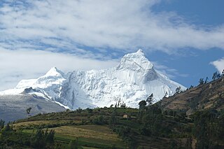
The Cordillera Blanca is a mountain range in Peru that is part of the larger Andes range and extends for 200 kilometres (124 mi) between 8°08' and 9°58'S and 77°00' and 77°52'W, in a northwesterly direction. It includes several peaks over 6,000 metres (19,690 ft) high and 722 individual glaciers. The highest mountain in Peru, Huascarán, at 6,768 metres (22,205 ft) high, is located there.

The Sierra de la Laguna is a mountain range at the southern end of the Baja California Peninsula in Mexico, and is the southernmost range of the Peninsular Ranges System.

The Sierra de Guadarrama is a mountain range forming the main eastern section of the Sistema Central, the system of mountain ranges along the centre of the Iberian Peninsula. It is located between the systems Sierra de Gredos in the province of Ávila, and Sierra de Ayllón in the province of Guadalajara.

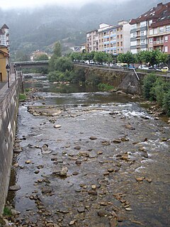
Nava is a municipality in the Autonomous Community of the Principality of Asturias, Spain. It is also the name of one of the parishes in this municipality, as well as the name of the municipal capital.
Navas de Estena is a municipality in Ciudad Real, Castile-La Mancha, Spain. It has a population of 404.
La Aldehuela is a municipality of Spain in the province of Ávila, in the Autonomous Community of Castile and León. It has a 17.04 km² area, a population of 233 inhabitants (2005) and a density of 13.91 people/km².

The Sierra Madre de Oaxaca is a mountain range in southern Mexico. It is primarily in the state of Oaxaca, and extends north into the states of Puebla and Veracruz.

Cómpeta is a town and municipality in the comarca of Axarquía, and province of Málaga, part of the autonomous community of Andalusia in southern Spain. The municipality is situated approximately 18 kilometres from the coast, and 52 kilometres from Málaga, the provincial capital. It is situated at 638 metres above sea level in the foothills of La Maroma. The population is spread over the southern slopes of the Sierra de Almijara.

The Gutiérrez Province is a province of the Colombian Department of Boyacá. The province is formed by six municipalities. The province is named after Colombian president José Santos Gutiérrez. The highest mountains of the Eastern Ranges of the Colombian Andes are located in the Gutiérrez Province. The Ritacuba Blanco, with 5,410 metres (17,750 ft) the highest peak in the Eastern Ranges is the second-most prominent peak of Colombia, after the highest double mountain Pico Cristóbal Colón.

The Valleys of the Saja and Nansa Rivers comprise an administrative comarca in Cantabria, Spain. It is formed by the valleys of said rivers, each one being a natural comarca of its own.
Borines is one of 24 parishes in Piloña, a municipality within the province and autonomous community of Asturias, in northern Spain.
Espinaredo is one of 24 parishes in Piloña, a municipality within the province and autonomous community of Asturias, in northern Spain.
Sorribas is one of 24 parishes in Piloña, a municipality within the province and autonomous community of Asturias, in northern Spain.

The Sierra del Sueve is a limestone massif located close to the coast in the east-central area of Asturias, Spain. It is a northern foothill of the Cantabrian Mountains. The range is located in the municipalities of northeast Caravia, Colunga in the northwest, Piloña, Parres and Ribadesella to the east and south.
La Mira is a peak of the Sierra de Gredos range in central Spain. It is located in the central part of the Sierra de Gredos range, a subrange of the larger Sistema Central, in the autonomous community of Castile and León. Listed at 2,343 metres (7,687 ft), it marks the common boundary of Arenas de San Pedro, Guisando, El Hornillo and Hoyos del Espino municipalities.

The Serra de Rubió is a mountain range located in Catalonia, Spain, between the comarques of Anoia and Bages, and among the municipalities of Rubió, Castellfollit del Boix, Òdena and Els Prats de Rei. Its highest peak is the Còpia de Palomes, with an elevation of 837-metre-high (2,746 ft). It has a length of roughly 12-kilometre (39,370 ft), and 9-kilometre (29,528 ft) of width.

The Peña de Francia is a mountain that rises to 1,727 m (5,666 ft), south of the Salamanca, Autonomous Region of Castile and León, Spain, whose peak belongs to the municipality of El Cabaco.

La Pinareja is a 2,197-metre-high (7,208 ft) mountain in Spain.