This page is based on this
Wikipedia article Text is available under the
CC BY-SA 4.0 license; additional terms may apply.
Images, videos and audio are available under their respective licenses.

Dennis Township is a township in Cape May County, New Jersey, United States. It is part of the Ocean City Metropolitan Statistical Area. The township's population as of the 2010 United States Census was 6,467, reflecting a decline of 25 (-0.4%) from the 6,492 counted in the 2000 Census, which had in turn increased by 918 (+16.5%) from the 5,574 counted in the 1990 Census.

Lower Township is a township in Cape May County, New Jersey, United States. It is part of the Ocean City Metropolitan Statistical Area. As of the 2010 United States Census, the township's population was 22,866, reflecting a decrease of 79 (-0.3%) from the 22,945 counted in the 2000 Census, which had in turn increased by 2,125 (+10.2%) from the 20,820 counted in the 1990 Census.

Hilltown Township is a township in Bucks County, Pennsylvania, United States. The population was 15,029 at the 2010 census. Hilltown is part of Pennridge School District.
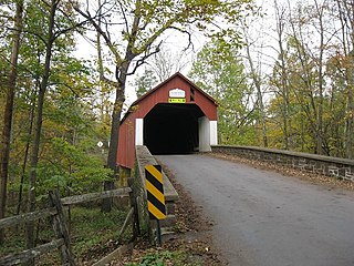
Tinicum Township is a township in Bucks County, Pennsylvania, United States. The population was 3,995 at the 2010 census.

Broadland is a local government district in Norfolk, England, named after the Norfolk Broads. The population of the Local Authority District taken at the 2011 Census was 124,646. Its council is based in Thorpe St Andrew, which is a suburb of the City of Norwich.

North Norfolk is a local government district in Norfolk, England. Its council is based in Cromer. The population at the 2011 Census was 101,149.

Mid Norfolk is a constituency represented in the House of Commons of the UK Parliament since 2010 by George Freeman, a Conservative.
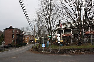
Point Pleasant is an unincorporated community in Tinicum and Plumstead Townships of Bucks County, Pennsylvania, United States. It lies on both sides of Tohickon Creek by the creek's confluence with the Delaware River; the creek is the dividing line between the townships. The ZIP code for the post office in Point Pleasant is 18950.

Grassy Park is a suburb in the Western Cape Province of South Africa, situated on the Cape Flats in the City of Cape Town.

Great and Little Plumstead is a civil parish in the English county of Norfolk consisting of the villages of Great Plumstead, Little Plumstead and Thorpe End.
It covers an area of 11.04 km2 (4.26 sq mi) and had a population of 2,618 in 972 households at the 2001 census,. increasing to a population of 3,135 in 1,228 households at the 2011 Census.
For the purposes of local government, it falls within the district of Broadland.

The 143rd Pennsylvania House of Representatives District is located in Southeastern Pennsylvania and has been represented since 2019 by Wendy Ullman.

Pipersville is an unincorporated community in Bedminster Township and Plumstead Township in Bucks County, Pennsylvania, United States. Pipersville is located at the intersection of Pennsylvania Route 611 and Pennsylvania Route 413.

Gardenville is an unincorporated community in Plumstead Township in Bucks County, Pennsylvania, United States. Gardenville is located at the intersection of Pennsylvania Route 413 and Point Pleasant Pike.
Fountainville is an unincorporated community in Bucks County, Pennsylvania, United States. Fountainville is located at the intersection of Pennsylvania Route 313 and Ferry Road at the tripoint of Doylestown, New Britain, and Plumstead townships.
Danboro is an unincorporated community in Plumstead Township in Bucks County, Pennsylvania, United States. Danboro is located at the intersection of Ferry Road/Danboro Point Pleasant Pike and Old Easton Road north of Doylestown.


