
Midsund is a municipality in Møre og Romsdal county, Norway. It is part of the Romsdal region. The administrative centre is the village of Midsund on Otrøya island. Other settlements on the island include Uglvik and Raknes in the north and Nord-Heggdal in the southeast.

Askvoll (help·info) is a municipality in Sogn og Fjordane county, Norway. It is located in the traditional district of Sunnfjord. The administrative centre is the village of Askvoll. Other villages in the municipality include Holmedal, Kvammen, and Stongfjorden. The most important industries in Askvoll today are Helle Knivfabrikk, Bulandet Fiskeindustri, and Sigurd Løkeland Hermetikkfabrikk.

Snillfjord is a municipality in Trøndelag county, Norway. It is part of the Fosen region. The administrative centre of the municipality is the village of Krokstadøra. Other villages in Snillfjord include Ytre Snillfjord, Hemnskjela, and Vutudal.

North Cape is a cape on the northern coast of the island of Magerøya in Northern Norway. The cape is in Nordkapp Municipality in Finnmark county, Norway. The European route E69 highway has its northern terminus at North Cape, which makes it the northernmost point in Europe that can be accessed by car and makes the E69 the northernmost public road in Europe. The plateau is a popular tourist attraction. The cape includes a 307-metre-high cliff (1,007 ft) with a large flat plateau on top, where visitors, weather permitting, can watch the midnight sun and views of the Barents Sea to the north. North Cape Hall, a visitor centre, was built in 1988 on the plateau. It includes a café, restaurant, post office, souvenir shop, a small museum, and video cinema.

Altevatnet (Norwegian) or Álddesjávri (Northern Sami) is Norway’s 11th largest lake. The 79.71-square-kilometre (30.78 sq mi) lake lies in the Bardu Municipality in Troms county, Norway. The lake is the largest lake in the county. It is approximately 38 kilometres (24 mi) long and about 2.5 kilometres (1.6 mi) wide. The lake is regulated by a dam on the northwestern end of the lake. The surface lies 489 metres (1,604 ft) above sea level and reaches a maximum depth of 99 metres (325 ft) below the surface of the lake.

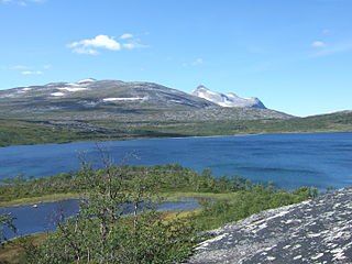
Tunnsjøen (Norwegian) or Dåtnejaevrie (Southern Sami) is a lake in the municipalities of Røyrvik and Lierne in Trøndelag county, Norway. The 100.18-square-kilometre (38.68 sq mi) lake lies just south of the large lake Limingen, and just west of the border with Sweden. It is 358 metres (1,175 ft) above sea level and has a volume of 8.68 cubic kilometres (2.08 cu mi). The deepest part of the lake is 220 metres (720 ft) deep. It is the seventh largest lake in Norway.

Balvatnet (Norwegian) or Bállávrre (Lule Sami) is a lake that lies in the municipality of Saltdal in Nordland county, Norway. The 41.46-square-kilometre (16.01 sq mi) lake is located on the border of Junkerdal National Park, about 2 kilometres (1.2 mi) west of the border with Sweden. The lake is regulated for hydroelectric power at the Daja Hydroelectric Power Station 16 kilometres (9.9 mi) to the north in Sulitjelma.
Kjemåvatnet (Norwegian) or Giebbnejávrre (Lule Sami) is a lake that lies in the municipality of Saltdal in Nordland county, Norway. The 2.64-square-kilometre (1.02 sq mi) lake lies about 2 kilometres (1.2 mi) west of the village of Lønsdal.

Mjåvatnet is a lake that lies in the municipality of Vefsn in Nordland county, Norway. The long, skinny, 2.61-square-kilometre (1.01 sq mi) lake lies between the lakes Ømmervatnet and Fustvatnet, about 15 kilometres (9.3 mi) northeast of the town of Mosjøen. The European route E06 highway passes along the west coast of the lake.

Øyungen is a lake in the municipality of Holtålen in Trøndelag county, Norway. The 6.13-square-kilometre (2.37 sq mi) lake lies about 7 kilometres (4.3 mi) southwest of the village of Hessdalen. The Forollhogna National Park surrounds the lake on three sides.
Riasten is a lake in the municipality of Holtålen in Trøndelag county, Norway. The 5.14-square-kilometre (1.98 sq mi) lake lies near the municipal border with the neighboring municipalities of Tydal and Røros, about 25 kilometres (16 mi) east of the village of Renbygda. The lake lies about 15 kilometres (9.3 mi) west of the border with Sweden.
Øyangsvatnet is a lake in the municipality of Agdenes in Trøndelag county, Norway. The lake lies in the west central part of Agdenes, just east of the border with Snillfjord municipality. The lake is about 6.5 kilometres (4.0 mi) west of the villages of Lensvik and Selbekken and about 9 kilometres (5.6 mi) west of the village of Ingdalen.

Svorksjøen is a lake in Trøndelag county, Norway. The 3.55-square-kilometre (1.37 sq mi) lake lies on the border of the municipalities of Melhus, Meldal, and Orkdal. The lake lies about 6 kilometres (3.7 mi) east of the village of Svorkmo in Orkdal and about 10 kilometres (6.2 mi) southwest of the village of Korsvegen in Melhus.
Hostovatnet is a lake in Trøndelag county, Norway. The 3.14-square-kilometre (1.21 sq mi) lake lies on the border of the municipalities of Orkdal and Meldal. The village of Hoston is located on the northeastern shore of the lake.
Austrumdalsvatnet is a lake in the municipality of Bjerkreim in Rogaland county, Norway. The 2.81-square-kilometre (1.08 sq mi) lake lies about 2.5 kilometres (1.6 mi) southeast of the lakes Hofreistæ and Byrkjelandsvatnet. The village of Øvrebygd lies about 3 kilometres (1.9 mi) west of the lake.
Gilten is a lake in the municipality of Steinkjer in Trøndelag county, Norway. The 31.62-square-kilometre (12.21 sq mi) lake lies in the northern part of Steinkjer, about 8 kilometres (5.0 mi) northeast of the village of Kvam, about 1.5 kilometres (0.93 mi) north of the village of Følling, and about 14 kilometres (8.7 mi) east of the village of Namdalseid. The lake is only accessible by road from Namdalseid, even though most of the 31.62-square-kilometre (12.21 sq mi) lake lies in Steinkjer. The lake Bangsjøan lies to the northeast and the lake Snåsavatnet lies to the south.

Sundvatnet (Norwegian) or Sopmirjávri (Northern Sami) is a lake in Deatnu-Tana Municipality in Finnmark county, Norway. The 5.54-square-kilometre (2.14 sq mi) lake lies about 5 kilometres (3.1 mi) northwest of the village of Rustefjelbma. The Tanafjorden lies less than 1 kilometre (0.62 mi) west of the lake.

Lysvatnet (Norwegian) or Čáhppesjávri (Northern Sami) is a lake in Lenvik Municipality in Troms county, Norway. The lake lies in the Helvetesdalen valley on the island of Senja. The 6-kilometre (3.7 mi) long lake covers an area of 3.67 square kilometres (1.42 sq mi). The lake lies about 10 kilometres (6.2 mi) west of the village of Gibostad.

Linesøya is an island in the municipality of Åfjord in Trøndelag county, Norway. It lies about 3 kilometres (1.9 mi) off the coast of the mainland of Åfjord, and 1 kilometre (0.62 mi) southwest of the island of Stokkøya. The 16.6-square-kilometre (6.4 sq mi) island also lies about 6.5 kilometres (4.0 mi) north of the smaller island of Lauvøya. The highest point on Linesøya is the 230-metre (750 ft) tall mountain Linesfjellet.

Rørstad is a village in the municipality of Sørfold in Nordland county, Norway. The village is located along the Sørfolda fjord, about 25 kilometres (16 mi) south of the village of Nordfold and about 15 kilometres (9.3 mi) northwest of the village of Røsvika. The historic Rørstad Church is located in the village, and worship services are held there twice each summer.


