Rennesøy (island)

Last updated
Rennesøy
Rennesoy og Mosteroy, Rogaland.JPG
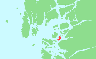
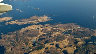
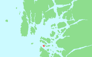
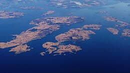
Rennesøy island is located towards the left side of the aerial view.
Norway Rogaland location map.svg
Red pog.svg
Rennesøy
Location in Rogaland county
Geography
Location Rogaland, Norway
Coordinates 59°05′27″N5°42′59″E / 59.0907°N 5.7163°E / 59.0907; 5.7163 Coordinates: 59°05′27″N5°42′59″E / 59.0907°N 5.7163°E / 59.0907; 5.7163
Area40.7 km2 (15.7 sq mi)
Length13.25 km (8.233 mi)
Width5 km (3.1 mi)
Highest elevation234 m (768 ft)
Highest pointHodnenuten
Administration
County Rogaland
Municipality Rennesøy

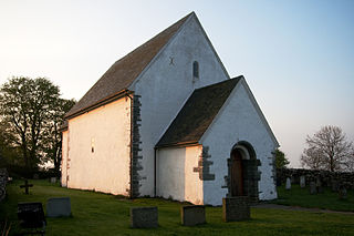
Rennesøy is an island in Rennesøy municipality in Rogaland county, Norway. The 40.7-square-kilometre (15.7 sq mi) island lies on the south side of the Boknafjorden, surrounded by several other islands. The islands of Mosterøy, Klosterøy, and Åmøy lie to the south and Finnøy and Talgje lie to the northeast. The villages of Vikevåg and Sørbø are both located on the island. Vikevåg is the administrative centre of the municipality. [1] The Hausken Church is located in Vikevåg and the 900-year old Sørbø Church is located in Sørbø.

Island Any piece of sub-continental land that is surrounded by water

An island or isle is any piece of sub-continental land that is surrounded by water. Very small islands such as emergent land features on atolls can be called islets, skerries, cays or keys. An island in a river or a lake island may be called an eyot or ait, and a small island off the coast may be called a holm. A grouping of geographically or geologically related islands is called an archipelago, such as the Philippines.

Rennesøy Municipality in Rogaland, Norway

Rennesøy is an island municipality in Rogaland county, Norway. It is located in the traditional district of Ryfylke. The administrative centre of the municipality is the village of Vikevåg. Other villages in Rennesøy include Askje and Sørbø. The municipality encompasses a number of islands on the south side of the Boknafjorden, north of the city of Stavanger.

Rogaland County (fylke) of Norway

Rogaland[²ruːɡɑlɑn](listen) is a county in Western Norway, bordering Hordaland, Telemark, Aust-Agder, and Vest-Agder counties. Rogaland is the center of the Norwegian petroleum industry. In 2016, Rogaland had an unemployment rate of 4.9%, one of the highest in Norway. In 2015, Rogaland had a fertility rate of 1.78 children per woman, which is the highest in the country.

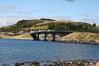
Since 1992, the island is connected to the mainland city of Stavanger by a series of bridges and tunnels that are part of the European route E39 highway: the Mastrafjord Tunnel, the Askjesund Bridge, and the Byfjord Tunnel. The island of Rennesøy is also connected to the islands of Finnøy and Talgje to the northeast by the Finnøy Tunnel. [1]

Stavanger Municipality in Norway

Stavanger is a city and municipality in Norway. It is the third largest city and metropolitan area in Norway and the administrative centre of Rogaland county. The municipality is the fourth most populous in Norway. Located on the Stavanger Peninsula in Southwest Norway, Stavanger counts its official founding year as 1125, the year the Stavanger Cathedral was completed. Stavanger's core is to a large degree 18th- and 19th-century wooden houses that are protected and considered part of the city's cultural heritage. This has caused the town centre and inner city to retain a small-town character with an unusually high ratio of detached houses, and has contributed significantly to spreading the city's population growth to outlying parts of Greater Stavanger.

European route E39 highway in Norway and Denmark

E 39 is the designation of a 1330 km long north-south road in Norway and Denmark, running from Klett just south of Trondheim to Aalborg, via Orkanger, Vinjeøra, Halsa ... Straumsnes, Krifast, Batnfjordsøra, Molde ... Vestnes, Skodje, Ålesund ... Volda ... Nordfjordeid ... Sandane, Førde, Lavik ... Instefjord, Knarvik, Bergen, Os ... Stord, Sveio, Aksdal, Bokn ... Rennesøy, Randaberg, Stavanger, Sandnes, Ålgård, Helleland, Flekkefjord, Lyngdal, Mandal, Kristiansand ... Hirtshals, Hjørring, and Nørresundby. Several sections are via ferry, denoted by ... in the above list. In total there are nine ferries, the highest number of ferries for a single road in Europe.

Mastrafjord Tunnel

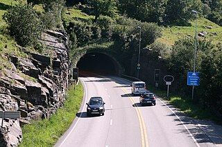
The Mastrafjord Tunnel is a subsea road tunnel in Rennesøy municipality in Rogaland county, Norway. The 4,424-metre (2.75 mi) long tunnel runs under the Mastrafjorden, which flows between the islands of Mosterøy and Rennesøy. The tunnel opened in 1992 as part of the European route E39 highway and the Rennesøy Fixed Link. The southern end of the tunnel is located near the village of Askje on Mosterøy and the northern end of the tunnel is in the village of Vikevåg on Rennesøy. With a maximum grade of 8%, the tunnel reaches its deepest point at 133 metres (436 ft) below sea level.

Rennesøy has a steep mountainous area in the southeast, with the 234-metre (768 ft) tall mountain Hodnenuten being the highest point on the mountain. The western part of the island is relatively flat and well cultivated. [1]

See also

Related Research Articles

Bokn Municipality in Rogaland, Norway

Bokn is a municipality in Rogaland county, Norway. It is located in the traditional district of Haugaland. The administrative centre of the municipality is the village of Føresvik, the only urban area in Bokn. Other villages in Bokn include Arsvågen, Trosnavåg, and Loten. The island municipality is mostly located on the three islands of Ognøya, Vestre Bokn, and Austre Bokn. All three main islands are connected to the mainland via a network of bridges.

Finnøy Municipality in Rogaland, Norway

Finnøy is an island municipality in Rogaland county, Norway. It is located in the traditional district of Ryfylke. The administrative centre of the municipality is the village of Judaberg.

Ryfylke District in Rogaland, Norway

Ryfylke is a traditional district in the northeastern part of Rogaland county, Norway. The 4,546-square-kilometre (1,755 sq mi) district is located northeast of the city of Stavanger and east of the city of Haugesund and it encompasses about 60% of the county's area. It includes the mainland located northeast and east of the Boknafjorden and east of the Høgsfjorden. It also includes the islands located on the south side of the Boknafjorden. To the east, Ryfylke borders the districts of Setesdal and Sirdal, to the south is Jæren, and to the west is Haugalandet. Ryfylke is one of the 15 districts in Western Norway.

Boknafjord human settlement

Boknafjord or Boknafjorden is a fjord located in Rogaland county, Norway. The huge fjord lies between the cities Stavanger and Haugesund, and the main part of the fjord is shared between the municipalities of Kvitsøy, Rennesøy, Finnøy, Tysvær, Bokn, and Karmøy. There are dozens of smaller fjords that branch off the main part of the fjord, reaching most municipalities in the county. At its longest, the Boknafjord reaches about 96 kilometres (60 mi) into the mainland at the innermost point of the Hylsfjorden. Other notable branches include the Saudafjorden, Sandsfjorden, Vindafjorden, Hervikfjorden, Førresfjorden, Erfjorden, Jøsenfjorden, Årdalsfjorden, Idsefjorden, Høgsfjorden, Lysefjorden, and Gandsfjorden.

Fogn island in Norway

Fogn is an island in Finnøy municipality in Rogaland county, Norway. The 10.4-square-kilometre (4.0 sq mi) island lies southeast of the island of Finnøy and northeast of the island of Talgje. The Finnøyfjorden lies between Fogn and Finnøy and the Fognafjorden lies between Fogn and the mainland to the southeast. The highest point on the island is the 166-metre (545 ft) tall mountain Domfjellet. Fogn Church is located on the island.

Judaberg Village in Western Norway, Norway

Judaberg is the administrative centre of Finnøy municipality in Rogaland county, Norway. The village is located on the eastern shore of the island of Finnøy. The island is located on the south side of the Boknafjorden, northeast of the large city of Stavanger.

Talgje

Talgje is a populated island in southwestern Finnøy municipality in Rogaland county, Norway. The 4.1-square-kilometre (1.6 sq mi) island is located in the Talgjefjorden and Brimsefjorden, both arms off of the main Boknafjorden in a large archipelago of islands northeast of the city of Stavanger. It is surrounded by islands: Brimse to the south, Rennesøy to the west, Finnøy to the north, and Fogn to the northeast. The island has a lot of agricultural uses, especially in growing tomatoes.

The Finnøy Tunnel or Finnøy Fixed Link is an undersea road tunnel in Rogaland county, Norway. It connects the island of Finnøy to the nearby island of Rennesøy, and ultimately to the mainland. The main tunnel is 5,685 metres (3.53 mi) long and it also includes a 1,467-metre (0.91 mi) long arm, which connects the tunnel to the island of Talgje.

Vestre Bokn isle in Norway

Vestre Bokn is an island in Bokn municipality in Rogaland county, Norway. The 36-square-kilometre (14 sq mi) island is the main island of the municipality. It lies on the northern side of the Boknafjorden at the southern end of the Karmsundet strait. Vestre Bokn lies between the islands of Karmøy and Austre Bokn and Ognøya. The main population centre on the island is the village of Føresvik, the administrative centre of the whole municipality. There are about 661 inhabitants on the island.

Bru, Rogaland island in Rennesøy, Norway

Bru is an island in Rennesøy municipality in Rogaland county, Norway. The 3-square-kilometre (1.2 sq mi) island lies south of the Boknafjorden, just off the coast of the Stavanger peninsula, along the Byfjorden. The highest point on the island is the 92-metre (302 ft) tall mountain, Brufjellet. The island sits in a group of islands with Sokn and Mosterøy to the north and Åmøy to the east.

Finnøy (island) island in Finnøy municipality in Rogaland county, Norway

Finnøy is an island in Finnøy municipality in Rogaland county, Norway. The 25-square-kilometre (9.7 sq mi) island is one of the largest in the island municipality. The administrative centre, Judaberg, is located on the eastern shore of the island. The island is located on the southern side of the Boknafjorden, about 20 kilometres (12 mi) northeast of the city of Stavanger. The village of Hesby, on the western coast, is a historical seat of power dating back to the Middle Ages. Hesby is also the site of Hesby Church which dates back to around the year 1100.

Mosterøy (island)

Mosterøy or Mosterøya is an island in Rennesøy municipality in Rogaland county, Norway. The 12-square-kilometre (4.6 sq mi) island lies just southwest of the island of Rennesøy. The smaller islands of Sokn, Bru, and Åmøy lie to the south of Mosterøy and the islands of Klosterøy and Fjøløy lie to the west of Mosterøy. All of these islands are connected together and to the mainland city of Stavanger by a series of undersea tunnels and bridges. The Mastrafjord Tunnel connects Mosterøy to the island of Rennesøy and the Askjesund Bridge connects Mosterøy to the island of Sokn. Both the tunnel and bridge are part of the European route E39 highway.

Klosterøy island in Rennesøy, Norway

Klosterøy is an island in Rennesøy municipality in Rogaland county, Norway. The 1.7-square-kilometre (0.66 sq mi) island lies on the south side of the Boknafjorden in the Rennesøy island group. It lies immediately north of the island of Fjøløy and immediately west of the island of Mosterøy. All three islands are connected by bridges and Mosterøy is connected to the island of Sokn which in turn is connected to the mainland by the Byfjord Tunnel.

Fjøløy

Fjøløy is an island in Rennesøy municipality in Rogaland county, Norway. The 2.1-square-kilometre (0.81 sq mi) island lies on the south side of the Boknafjorden in the Rennesøy island group. The island lies immediately south of the island of Klosterøy and west of the island of Mosterøy. The island is connected to the mainland by a series of bridges and tunnels. The Fjøløy Lighthouse is located on the western end of the island.

Vikevåg Village in Western Norway, Norway

Vikevåg is the administrative centre of Rennesøy municipality in Rogaland county, Norway. The village is located on the south side of the island of Rennesøy. The northern end of the Mastrafjord Tunnel lies at Vikevåg. The tunnel is part of the European route E39 highway. Hausken Church is located in Vikevåg.

Hausken Church Church in Rogaland, Norway

Hausken Church is a parish church in Rennesøy municipality in Rogaland county, Norway. It is located in the village of Vikevåg on the island of Rennesøy. The church is part of the Rennesøy parish in the Tungenes deanery in the Diocese of Stavanger. The white, wooden church was built in 1857 using designs by the architect Christian Heinrich Grosch. The church seats about 250 people.

Sørbø Church Church in Rogaland, Norway

Sørbø Church is a parish church in Rennesøy municipality in Rogaland county, Norway. It is located in the village of Sørbø on the island of Rennesøy. The church is part of the Rennesøy parish in the Tungenes deanery in the Diocese of Stavanger. The stone church was built as a royal chapel in the early 1100s. It seats about 100 people. The church had a steeple for hundreds of years, but it was removed in 1883.

Sjernarøyane island group

Sjernarøyane is an island group in Finnøy municipality in Rogaland county, Norway. The islands are located in the Nedstrandsfjorden, west of the large island of Ombo and north of the large island of Finnøy. As of 2014, the islands were home to 365 residents. The islands were historically part of the municipality of Sjernarøy before merging into the municipality of Finnøy in 1965. The Aubøsund strait, which runs between the islands of Aubø and Bjergøy was a historically important trading post.

Talgje Church Church in Rogaland, Norway

Talgje Church is a parish church in Finnøy municipality in Rogaland county, Norway. It is located on the island of Talgje. The church is part of the Talgje parish in the Tungenes deanery in the Diocese of Stavanger. The stone church was built around the year 1100. It seats about 130 people. The church was built as part of a large estate on Talgje. The estate was owned by old Norwegian nobility throughout the middle ages. Gaute Erlingsson owned the estate for a time. The church is dedicated to the Virgin Mary.

References

  1. 1 2 3 Store norske leksikon. "Rennesøy – øy" (in Norwegian). Retrieved 2015-12-16.