Smart growth is an urban planning and transportation theory that concentrates growth in compact walkable urban centers to avoid sprawl. It also advocates compact, transit-oriented, walkable, bicycle-friendly land use, including neighborhood schools, complete streets, and mixed-use development with a range of housing choices. The term "smart growth" is particularly used in North America. In Europe and particularly the UK, the terms "compact city", "urban densification" or "urban intensification" have often been used to describe similar concepts, which have influenced government planning policies in the UK, the Netherlands and several other European countries.

Zoning is the process of dividing land in a municipality into zones in which certain land uses are permitted or prohibited. In addition, the sizes, bulk, and placement of buildings may be regulated. The type of zone determines whether planning permission for a given development is granted. Zoning may specify a variety of outright and conditional uses of land. It may also indicate the size and dimensions of land area as well as the form and scale of buildings. These guidelines are set in order to guide urban growth and development.
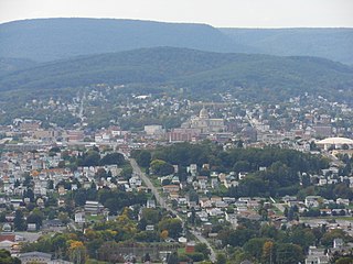
Altoona is a city in Blair County, Pennsylvania, United States. It is the principal city of the Altoona Metropolitan Statistical Area (MSA). The population was 46,320 at the time of the 2010 Census, making it the eleventh most populous city in Pennsylvania. The Altoona MSA includes all of Blair County and was recorded as having a population of 127,089 at the 2010 Census, around 100,000 of whom live within a 5-mile (8.0 km) radius of the Altoona city center according to U.S. Census ZIP Code population data. This includes the adjacent boroughs of Hollidaysburg and Duncansville, adjacent townships of Logan, Allegheny, Blair, Frankstown, Antis, and Tyrone, as well as nearby boroughs of Bellwood and Newry.

Urban renewal is a program of land redevelopment in cities, often where there is urban decay. Urban renewal often refers to the clearing out of blighted areas in inner cities to clear out slums and create opportunities for higher class housing, businesses, and more. Modern attempts at renewal began in the late 19th century in developed nations, and experienced an intense phase in the late 1940s under the rubric of reconstruction. The process has had a major impact on many urban landscapes, and has played an important role in the history and demographics of cities around the world.

Pedestrian zones are areas of a city or town reserved for pedestrian-only use and in which most or all automobile traffic may be prohibited. Converting a street or an area to pedestrian-only use is called pedestrianisation. Pedestrianisation usually aims to provide better accessibility and mobility for pedestrians, to enhance the volume of shopping and other business activity in the area and/or to improve the attractiveness of the local environment in terms of aesthetics, air pollution, noise and crash involving motor vehicle with pedestrians. However, pedestrianisation can sometimes lead to reductions in business activity, property devaluation, and displacement of economic activity to other areas. In some cases traffic in surrounding areas may increase, due to displacement rather than substitution of car traffic. Nonetheless, pedestrianisation schemes are often associated with significant drops in local air and noise pollution, accidents, and frequently with increased retail turnover and increased property values locally. A car-free development generally implies a large scale pedestrianised area that relies on modes of transport other than the car, while pedestrian zones may vary in size from a single square to entire districts, but with highly variable degrees of dependence on cars for their broader transport links.

A residential area is a land used in which housing predominates, as opposed to industrial and commercial areas. Housing may vary significantly between, and through, residential areas. These include single-family housing, multi-family residential, or mobile homes. Zoning for residential use may permit some services or work opportunities or may totally exclude business and industry. It may permit high density land use or only permit low density uses. Residential zoning usually includes a smaller FAR than business, commercial or industrial/manufacturing zoning. The area may be large or small.

The car-free movement is a broad, informal, emergent network of individuals and organizations including social activists, urban planners, transportation engineers and others, brought together by a shared belief that large and/or high-speed motorized vehicles are too dominant in most modern cities. The goal of the movement is to create places where motorized vehicle use is greatly reduced or eliminated, to convert road and parking space to other public uses and to rebuild compact urban environments where most destinations are within easy reach by other means, including walking, cycling, personal transporters, low impact vehicles such as golf carts, neighborhood electric vehicles, kei cars and quadricycles, mobility as a service or public transport.
City of Cleburne v. Cleburne Living Center, Inc., 473 U.S. 432 (1985), was a U.S. Supreme Court case involving discrimination against the intellectually disabled.

A driveway is a type of private road for local access to one or a small group of structures, and is owned and maintained by an individual or group.

Hillcrest is a suburban neighborhood in San Diego, California northwest of Balboa Park and south of Mission Valley.

Brightwood is a neighborhood located in the northwestern quadrant of Washington, D.C. Brightwood is part of Ward 4.
Mixed-use development or often simply Live-work space is a type of urban development strategy for living spaces (housing) that blends residential, commercial, cultural, institutional, or entertainment uses, where those functions are physically and functionally integrated, and that provides pedestrian connections. Mixed-use development can take the form of a single building, a city block, or entire neighbourhoods. The term may also be used more specifically to refer to a mixed-use real estate development project—a building, complex of buildings, or district of a town or city that is developed for mixed-use by a private developer, (quasi-) governmental agency, or a combination thereof.

A disabled parking permit, also known as a disabled badge, disabled placard, handicapped permit, handicapped placard, handicapped tag, and "Blue Badge" in the European Union, is displayed upon parking a vehicle permitting the operator of a vehicle to special privileges regarding the parking of that vehicle. These privileges include parking in a space reserved for persons with disabilities, or in some situations, permission to park in a time-limited space for a longer time, or to park at a meter without payment.

Automobile dependency is the concept that some city layouts cause automobiles to be favored over alternate forms of transportation such as bicycles, public transit, and walking.

Zoning in the United States includes various land use laws falling under the police power rights of state governments and local governments to exercise authority over privately owned real property. The earliest zoning laws originated with the Los Angeles zoning ordinances of 1908 and the New York City Zoning resolution of 1916. Starting in the early 1920s, the United States Commerce Department drafted model zoning and planning ordinances in the 1920s to facilitate states in drafting enabling laws. Also in the early 1920s, a lawsuit challenged a local zoning ordinance in a suburb of Cleveland, which was eventually reviewed by the United States Supreme Court.

A parking chair is a chair that is used by a vehicle owner to informally mark a parking space as reserved. Other objects are also used for this purpose, including trash cans, ladders, ironing boards, and similar-sized objects. For curbside parking spaces, two or more items are normally used; for angle spaces, only one is needed.

Skanste is a neighbourhood located in the center of Riga, the capital of Latvia, and is currently becoming its most modern part. Geographically, the neighborhood is situated in the northern part of the railway ring on the right bank of the Daugava, bordering with the Sarkandaugava, Brasa, Centrs, and Pētersala-Andrejsala neighborhoods.
Burton v. Wilmington Parking Authority, 365 U.S. 715 (1961), was a United States Supreme Court case that considered the application of the Equal Protection Clause on a private business that operates in close relationship to a government to the point that it becomes a "state actor".

Mount Vernon Triangle is a neighborhood and community improvement district in the northwest quadrant of Washington, D.C. Originally a working-class neighborhood established in the 19th century, present-day Mount Vernon Triangle experienced a decline in the mid-20th century as it transitioned from residential to commercial and industrial use. The neighborhood has undergone significant and rapid redevelopment in the 21st century. It now consists mostly of high-rise condominium, apartment and office buildings. Several historic buildings in the neighborhood have been preserved and are listed on the National Register of Historic Places. Mount Vernon Triangle is now considered a good example of urban planning and a walkable neighborhood.


