Hydrology is the scientific study of the movement, distribution, and quality of water on Earth and other planets, including the water cycle, water resources and environmental watershed sustainability. A practitioner of hydrology is a hydrologist, working within the fields of earth or environmental science, physical geography, geology or civil and environmental engineering. Using various analytical methods and scientific techniques, they collect and analyze data to help solve water related problems such as environmental preservation, natural disasters, and water management.

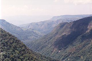
A drainage basin is any area of land where precipitation collects and drains off into a common outlet, such as into a river, bay, or other body of water. The drainage basin includes all the surface water from rain runoff, snowmelt, and nearby streams that run downslope towards the shared outlet, as well as the groundwater underneath the earth's surface. Drainage basins connect into other drainage basins at lower elevations in a hierarchical pattern, with smaller sub-drainage basins, which in turn drain into another common outlet.
Surface-water hydrology is the sub-field of hydrology concerned with above-earth water, in contrast to groundwater hydrology that deals with water below the surface of the Earth. Its applications include rainfall and runoff, the routes that surface water takes, and the occurrence of floods and droughts. Surface-water hydrology is used to predict the effects of water constructions such as dams and canals. It considers the layout of the watershed, geology, soils, vegetation, nutrients, energy and wildlife. Modelled aspects include precipitation, the interception of rain water by vegetation or artificial structures, evaporation, the runoff function and the soil-surface system itself.
The United States Environmental Protection Agency (EPA) Storm Water Management Model is a dynamic rainfall–runoff–subsurface runoff simulation model used for single-event to long-term (continuous) simulation of the surface/subsurface hydrology quantity and quality from primarily urban/suburban areas. It can simulate the Rainfall- runoff, runoff, evaporation, infiltration and groundwater connection for roots, streets, grassed areas, rain gardens and ditches and pipes, for example. The hydrology component of SWMM operates on a collection of subcatchment areas divided into impervious and pervious areas with and without depression storage to predict runoff and pollutant loads from precipitation, evaporation and infiltration losses from each of the subcatchment. Besides, low impact development (LID) and best management practice areas on the subcatchment can be modeled to reduce the impervious and pervious runoff. The routing or hydraulics section of SWMM transports this water and possible associated water quality constituents through a system of closed pipes, open channels, storage/treatment devices, ponds, storages, pumps, orifices, weirs, outlets, outfalls and other regulators. SWMM tracks the quantity and quality of the flow generated within each subcatchment, and the flow rate, flow depth, and quality of water in each pipe and channel during a simulation period composed of multiple fixed or variable time steps. The water quality constituents such as water quality constituents can be simulated from buildup on the subcatchments through washoff to a hydraulic network with optional first order decay and linked pollutant removal, best management practice and low-impact development removal and treatment can be simulated at selected storage nodes. SWMM is one of the hydrology transport models which the EPA and other agencies have applied widely throughout North America and through consultants and universities throughout the world. The latest update notes and new features can be found on the EPA website in the download section. Recently added in November 2015 were the EPA SWMM 5.1 Hydrology Manual and in 2016 the EPA SWMM 5.1 Hydraulic Manual and EPA SWMM 5.1 Water Quality Volume (III) + Errata”

An hydrological transport model is a mathematical model used to simulate river or stream flow and calculate water quality parameters. These models generally came into use in the 1960s and 1970s when demand for numerical forecasting of water quality was driven by environmental legislation, and at a similar time widespread access to significant computer power became available. Much of the original model development took place in the United States and United Kingdom, but today these models are refined and used worldwide.
The HBV hydrology model, or Hydrologiska Byråns Vattenbalansavdelning model, is a computer simulation used to analyze river discharge and water pollution. Developed originally for use in Scandinavia, this hydrological transport model has also been applied in a large number of catchments on most continents.
Intermittent rivers cease to flow every year or at least twice every five years. Such rivers drain large arid and semi-arid areas, covering approximately a third of the earth’s surface. The extent of temporary rivers is increasing, as many formerly perennial rivers are becoming temporary because of increasing water demand, particularly for irrigation. The combination of dry crusted soils and the highly erosive energy of the rain cause sediment resuspension and transport to the coastal areas. They are among the aquatic habitats most altered by human activities. During the summer even under no flow conditions the point sources are still active such as the wastewater effluents, resulting in nutrients and organic pollutants accumulating in the sediment. Sediment operates as a pollution inventory and pollutants are moved to the next basin with the first flush. Their vulnerability is intensified by the conflict between water use demand and aquatic ecosystem conservation. Advanced modelling tools have been developed to better describe intermittent flow dynamic changes such as the tempQsim model.

HydroGeoSphere (HGS) is a 3D control-volume finite element groundwater model, and is based on a rigorous conceptualization of the hydrologic system consisting of surface and subsurface flow regimes. The model is designed to take into account all key components of the hydrologic cycle. For each time step, the model solves surface and subsurface flow, solute and energy transport equations simultaneously, and provides a complete water and solute balance.
Hydrus is a suite of Windows-based modeling software that can be used for analysis of water flow, heat and solute transport in variably saturated porous media. HYDRUS suite of software is supported by an interactive graphics-based interface for data-preprocessing, discretization of the soil profile, and graphic presentation of the results. While HYDRUS-1D simulates water flow, solute and heat transport in one-dimension, and is a public domain software, HYDRUS 2D/3D extends the simulation capabilities to the second and third dimensions, and is distributed commercially.
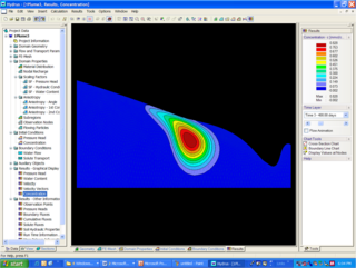
MIKE SHE is an integrated hydrological modelling system for building and simulating surface water flow and groundwater flow. MIKE SHE can simulate the entire land phase of the hydrologic cycle and allows components to be used independently and customized to local needs. MIKE SHE emerged from Système Hydrologique Européen (SHE) as developed and extensively applied since 1977 onwards by a consortium of three European organizations: the Institute of Hydrology, SOGREAH (France) and DHI (Denmark). Since then, DHI has continuously invested resources into research and development of MIKE SHE. MIKE SHE can be used for the analysis, planning and management of a wide range of water resources and environmental problems related to surface water and groundwater, especially surface-water impact from groundwater withdrawal, conjunctive use of groundwater and surface water, wetland management and restoration, river basin management and planning, impact studies for changes in land use and climate.
MIKE 11 is a computer program that simulates flow and water level, water quality and sediment transport in rivers, flood plains, irrigation canals, reservoirs and other inland water bodies. MIKE 11 is a 1-dimensional river model. It was developed by DHI.
GSSHA is a two-dimensional, physically based watershed model developed by the Engineer Research and Development Center of the United States Army Corps of Engineers. It simulates surface water and groundwater hydrology, erosion and sediment transport. The GSSHA model is used for hydraulic engineering and research, and is on the Federal Emergency Management Agency (FEMA) list of hydrologic models accepted for use in the national flood insurance program for flood hydrograph estimation. Input is best prepared by the Watershed Modeling System interface, which effectively links the model with geographic information systems (GIS).
The following outline is provided as an overview of and topical guide to hydrology:
SWAT-CUP is a program designed to integrate various calibration/uncertainty analysis programs for SWAT using the same interface. Currently the program can run SUFI2, GLUE, and ParaSol. To create a project, the program guides the user through the input files necessary for running a calibration program. Each SWAT-CUP project contains one calibration method and allows user to run the procedure many times until convergence is reached. User can save calibration iterations in the iteration history for later use. Also we have made it possible to create charts of observed and simulated data and the predicted uncertainty about them.
The Water Erosion Prediction Project (WEPP) Model is a physically based erosion simulation model built on the fundamentals of hydrology, plant science, hydraulics, and erosion mechanics. The model was developed by an interagency team of scientists to replace the Universal Soil Loss Equation (USLE) and has been widely used in the United States and the world. WEPP requires four inputs, i.e., climate, topography, soil, and management (vegetation); and provides various types of outputs, including water balance, soil detachment and deposition at points along the slope, sediment delivery, and vegetation growth. The WEPP model has been improved continuously since its public delivery in 1995, and is applicable for a variety of areas.
DPHM-RS is a semi-distributed hydrologic model developed at University of Alberta, Canada.
The Geochemist's Workbench (GWB) is an integrated set of interactive software tools for solving a range of problems in aqueous chemistry. The graphical user interface simplifies the use of the geochemical code.
The flash flood guidance system (FFGS) was designed and developed by the Hydrologic Research Center a non-profit public-benefit corporation located in of San Diego, CA, US, for use by meteorological and hydrologic forecasters throughout the world. The primary purpose of the FFGS is to provide operational forecasters and disaster management agencies with real-time informational guidance products pertaining to the threat of small-scale flash flooding throughout a specified region. The FFGS provides the necessary products to support the development of warnings for flash floods from rainfall events through the use of remote-sensed precipitation and hydrologic models. The FFGS outputs are made available to users to support their analysis of weather-related events that can initiate flash floods and then to make a rapid evaluation of the potential for a flash flood at a location. To assess the threat of a local flash flood, the FFGS is designed to allow product adjustments based on the forecaster’s experience with local conditions, incorporation of other information and any last minute local observations or local observer reports. The system supports evaluations of the threat of flash flooding over hourly to six-hourly time scales for stream basins that range in size from 25 to 200 km2 in size. Important technical elements of the flash flood guidance system are the development and use of a bias-corrected radar and/or satellite precipitation estimate field and the use of land-surface hydrologic modeling. The system then provides information on rainfall and hydrologic response, the two important factors in determining the potential for a flash flood. The system is based on the concept of flash flood guidance and flash flood threat. Both indices provide the user with the information needed to evaluate the potential for a flash flood, including assessing the uncertainty associated with the data.

Keith John Beven is a British hydrologist and distinguished Emeritus Professor in Hydrology at Lancaster University. According to Lancaster University he is the most highly cited hydrologist.