Saddle Peak is a mountain located in the Santa Monica Mountains between Malibu and Calabasas. The summit is accessible via the Backbone Trail. There is also a feeder trail to the top from near the top of Stunt Road (just 1 block below the ridge intersection with Scheuren Road at the viewpoint) maintained by the Santa Monica Mountains Conservancy. And there is an informal trail up the bottom East nose of the massif right across the intersection from the Scheuren Viewpoint. This latter trail passes around a water tower and eventually joins the main trails near the top.
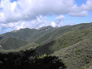
The Santa Monica Mountains is a coastal mountain range in Southern California, paralleling the Pacific Ocean. It is part of the Transverse Ranges. Because of its proximity to densely populated regions, it is one of the most visited natural areas in California. Santa Monica Mountains National Recreation Area is located in this mountain range.
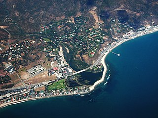
Malibu is a beach city in western Los Angeles County, California, situated about 30 miles (48 km) west of Downtown Los Angeles. It is known for its Mediterranean climate and its 21-mile (34 km) strip of the Malibu coast, incorporated in 1991 into the City of Malibu. The area is known for being the home of Hollywood movie stars, people in the entertainment industry, and other affluent residents. Most Malibu residents live within a few hundred yards of Pacific Coast Highway, which traverses the city, with some residents living up to a mile away from the beach up narrow canyons. As of the 2010 census, the city population was 12,645.
Calabasas is a city in Los Angeles County, California, United States, located in the hills west of the San Fernando Valley and in the northwest Santa Monica Mountains between Woodland Hills, Agoura Hills, West Hills, Hidden Hills, and Malibu, California. As of the 2010 census, the city's population was 23,058, up from 20,033 at the 2000 census. The city was formally incorporated in 1991.
Vegetation is sparse on the peak; dwarf forest and chaparral on the approaches, scrub and grassy at the top. Some oaks at lower elevations.
Dwarf forest, elfin forest, or pygmy forest is a rare ecosystem featuring miniature trees, inhabited by small species of fauna such as rodents and lizards. They are usually located at high elevations, under conditions of sufficient air humidity but poor soil. There are two main dwarf forest ecosystem types, involving different species and environmental characteristics: coastal temperate and montane tropical regions. Temperate coastal dwarf forest is common for parts of Southern California. Montane tropical forests are found across tropical highlands of Central America, northern South America and Southeast Asia. There are also other isolated examples of dwarf forests scattered across the world.
Chaparral is a shrubland or heathland plant community found primarily in the US state of California and in the northern portion of the Baja California Peninsula, Mexico. It is shaped by a Mediterranean climate and wildfire, featuring summer-drought-tolerant plants with hard sclerophyllous evergreen leaves, as contrasted with the associated soft-leaved, drought-deciduous, scrub community of coastal sage scrub, found below the chaparral biome. Chaparral covers 5% of the state of California and associated Mediterranean shrubland an additional 3.5%. The name comes from the Spanish word chaparro, for evergreen oak shrubland.
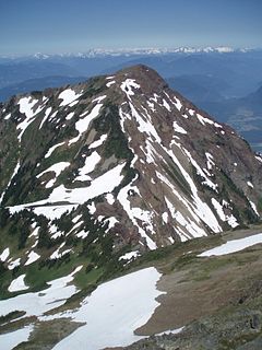
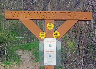
Photographed from the top of Saddle Peak, near Malibu California.
The true summit is the South Eastern hummock, much degraded. Views from here are of the Pacific Ocean to the West, and other ridges and peaks of the Santa Monica Mountains to the East and West. There is a second summit reached by private road, to the Northwest, with a wire-fenced compound of numerous radio relay towers. At the far end beyond the compound is a house site foundation in disrepair. This slope burned in 1989. Beyond and below that is a private road back down to Stunt Road, with private residences below.
There are occasionally rattlesnakes on the SMMC trail.
This page is based on this Wikipedia article Text is available under the CC BY-SA 4.0 license; additional terms may apply. Images, videos and audio are available under their respective licenses.
Related Research Articles
Hunter Mountain is in the towns of Hunter and Lexington, just south of the village of Hunter, in Greene County, New York, United States. At approximately 4,040 feet (1,231 m) in elevation, it is the highest peak in the county and the second-highest peak in the Catskill Mountains.
Cougar Mountain Regional Wildland Park is a regional park in King County, Washington, near the towns of Bellevue and Issaquah. The park was established in June 1983 to protect the central core of Cougar Mountain, the park covers 3,115 acres (12.61 km2) with 38 miles (61 km) of hiking trails and 12 miles (19 km) of equestrian trails.
Mount Monroe is a 5,372-foot-high (1,637 m) mountain peak southwest of Mount Washington in the Presidential Range of the White Mountains in New Hampshire, United States. It is named for American President James Monroe and is the fourth highest mountain on the 4000 footers list for New Hampshire. The Appalachian Trail skirts its summit, which is the next highest peak on or near the trail north of Mount Rogers in Virginia. The Lakes of the Clouds, and its AMC hut, lie nestled at the col between Mount Monroe and neighboring Mount Washington.
Slide Mountain is the highest peak in the Catskill Mountains of the U.S. state of New York. It is located in the town of Shandaken in Ulster County. While the 4,180-foot (1,270 m) contour line on topographic maps is generally accepted as its height, the exact elevation of the summit has never been officially determined by the U.S. Coast and Geodetic Survey, and many informal surveys suggest the mountain may actually top 4,200 feet above sea level.
Beacon Mountain, locally Mount Beacon, is the highest peak of Hudson Highlands, located behind the City of Beacon, New York, in the Town of Fishkill. Its two summits rise above the Hudson River behind the city and can easily be seen from Newburgh across the river and many other places in the region. The more accessible northern peak, at 1,531 feet above sea level, has a complex of radio antennas on its summit; the 1,610-foot southern summit has a fire lookout tower.
Cheam Peak or Mount Cheam.
Mount Hood, also known as Hood Mountain is a mountain near the southeastern edge of Santa Rosa, California at the northeast of the Sonoma Valley and attains a height of 2,733 feet (833 m). The original name was Mount Wilikos, an Indian name meaning "willows." Most of the drainage from Mount Hood contributes to the headwaters of Sonoma Creek. A prominent feature is the extensive rock face visible on the upper half of the mountain as viewed from State Route 12. The habitats on the mountain include mixed oak forest, pygmy forest, chaparral and riparian zones. In prehistoric times the slopes of Mount Hood were inhabited by a division of the Yuki tribe. Most of Mount Hood is within the Hood Mountain Regional Park maintained by Sonoma County. Mount Hood is part of the inner coast Mayacamas Range, and lies mostly within Sonoma County, with a part of the mountain geographically within Napa County. Mount Hood affords overlooks of the Pacific Ocean, San Francisco Bay and "a spectacular view east to the Sierra Nevada Range."
Rusk Mountain is a peak located in the towns of Jewett and Lexington in Greene County, New York, United States. At 3,680 feet in elevation, it is the 20th-highest peak in the Catskill Mountains and considered a member of the Catskill High Peaks. While there is no maintained trail, a bushwhack to the summit is considered relatively easy, and required for membership in the Catskill Mountain 3500 Club.
Black Cap is a mountain located in the town of Conway, New Hampshire, United States. It is located between Kearsarge North Mountain and Peaked Mountain. The rocky summit provides views of Maine and New Hampshire's White Mountains.
Tumbledown Mountain is a mountain in Franklin County, Maine. The mountain is a popular hiking spot in western Maine, with trailheads located on Byron Road in unincorporated Township 6, north of Weld. It is distinguished by an alpine pond just below the summit. Tumbledown Mountain is also located near Coos Canyon, a mountain stream. Tumbledown offers trails of varying difficulty for different hikers.
Balsam Lake Mountain is one of the Catskill Mountains, located in the Town of Hardenburgh, New York, United States. It is the westernmost of the range's 35 High Peaks. Its exact height has not been determined, but the highest contour line on topographic maps, 3,720 feet (1,130 m), is usually given as its elevation.
Graham Mountain is the seventh highest of the Catskill High Peaks and the highest privately owned mountain in the range. It is located in the town of Hardenburgh, New York, United States.
The Sugarland Mountain Trail is an American hiking trail, in the Great Smoky Mountains National Park of Sevier County, Tennessee. The trail traverses Sugarland Mountain, a massive ridge running perpendicular to the main crest of the Smokies and effectively dividing the park's north-central section from its northwestern section. Sugarland Mountain is flanked by the deep upper valleys of two of the park's major watersheds— the West Fork of the Little Pigeon River and Little River. The trail passes through several forest types, including deciduous forest at lower elevations, heaths ("hells") along the mountain's backbone formations, and a stand of Southern Appalachian spruce-fir forest in the upper elevations. Occasional breaks in the foliage allow for views of Mount Le Conte and Sevier County to the east and Blanket Mountain and the ridges above Elkmont to the west.
Brace Mountain is the peak of a ridge in the southern Taconic Mountains, near the tripoint of the U.S. states of New York, Connecticut and Massachusetts. Its 2,311-foot (704 m) main summit is located in New York; it is the highest point in that state's Dutchess County.
The Snake Den Ridge Trail is an American hiking trail in the Great Smoky Mountains National Park of Cocke County, Tennessee. Winding its way up the backbone-like crest of Snake Den Ridge, the trail connects the Cosby Campground to the Appalachian Trail and provides the quickest access to the high peaks of the Eastern Smokies. The trail passes through three forest types— a mixed deciduous forest at its lower elevations, a substantial stand of heath bald on the more narrow sections of the ridge crest, and an old growth northern-style coniferous forest at its higher elevations.
Marks Knob is a mountain in the Great Smoky Mountains, in the southeastern United States. It has an elevation of 6,169 feet (1,880 m), with 249 feet (76 m) of clean prominence. Its summit— located near the center of the Eastern Smokies amidst a dense stand of Southern Appalachian spruce-fir forest— is a popular bushwhacking destination and one of the most difficult-to-reach summits of the Southern Sixers.
Long Mountain, 920 feet (280 m) feet above sea level, is a traprock mountain of the Holyoke Range, part of the greater Metacomet Ridge which stretches from Long Island Sound to nearly the Vermont border. The mountain rises steeply from the surrounding landscape 600 feet (180 m) below and consists of five distinct peaks, from east to west: 685 feet (209 m), 775 feet (236 m), 795 feet (242 m), 920 feet (280 m), the high point, and the eastern summit, 906 feet (276 m). It is located within the towns of Amherst and Granby, Massachusetts. The 110-mile (180 km) Metacomet-Monadnock Trail and the 47-mile (76 km) Robert Frost Trail traverse the mountain. The Holyoke Range continues to the west as Mount Norwottuck and to the east as Harris Mountain.
Mount Tremper, officially known as Tremper Mountain and originally called Timothyberg, is one of the Catskill Mountains in the U.S. state of New York. It is located near the hamlet of Phoenicia, in the valley of Esopus Creek.
The Wilkinson Memorial Trail is a public footpath in the Hudson Highlands region of the U.S. state of New York. It generally follows the Dutchess–Putnam county line along the latter's northwest corner, from the banks of the Hudson River near Breakneck Ridge to North HIghland, just south of the county line in Philipstown. At 9.5 miles (15.3 km) in length it is the longest trail in the Hudson Highlands State Park system; although parts of the trail are on other public and private parcels in the area.