Panvel is a locality in Raigad district of Maharashtra in Konkan Division, and is a node of Navi Mumbai city. It is highly populated due to its closeness to Mumbai. Panvel is located in the Mumbai Metropolitan Region. Panvel is the first Municipal Corporation in Raigad and the 27th Municipal corporation of Maharashtra State.

Neral is a town in Raigad district in the Indian state of Maharashtra. It is 83 km from Mumbai-South and 42 km from Panvel in the Karjat tehsil. It is a rapidly developing city of a Raigad district which is well connected to Panvel, Mumbai, Thane and Pune. Neral along with Karjat is also known as Eastern Mumbai District.
Mumbai Metropolitan Region (MMR) is a metropolitan area in Maharashtra state, consisting of the state capital Mumbai and its satellite towns. Developing over a period of about 20 years, it consists of nine municipal corporations and fifteen smaller municipal councils. The entire area is overseen by the Mumbai Metropolitan Region Development Authority (MMRDA), a Maharashtra State Government organisation in charge of town planning, development, transportation and housing in the region.

The Deccan Queen or Deccan Queen Express, is an Indian passenger train that connects the two largest cities of the Indian state of Maharashtra, i.e. Mumbai and Pune. The service was named as Deccan Queen after the nickname for Pune: Queen of the Deccan.
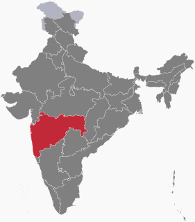
Raigad District is a district in the state of Maharashtra, India. Formerly called the Kolaba district, the district was renamed after Raigad, the fort that was the former capital of the Maratha Empire founder and leader Chhatrapati Shivaji Maharaj, and is located in the interior regions of the district, in dense forests on a west-facing spur of the Western Ghats of Sahyadri Range. In 2011 the district had a population of 2,635,394, compared to 2,207,929 in 2001. The name was changed in the regime of Chief Minister Antule on 1st Jan 1981. In 2011 urban dwellers had increased to 36.91% from 24.22% in 2001.
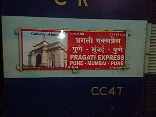
The Pragati Express is a daily intercity express train plying between Pune and Mumbai via Panvel. It is operated by the Central Railways, a zonal railway under the larger Indian Railways. Currently, it plies the distance of 187 km in 3 hours and 25 minutes.

Bhivpuri Road is a railway station on the Central line of the Mumbai Suburban Railway network in India. It is on the Karjat route. Neral is the previous stop and Karjat is the next stop.

Chikhale is a village in Panvel Taluk of Raigad district in Maharashtra state in India. It is located at a distance of 6.2 km from its Taluk headquarters Panvel and 33 km distance from Mumbai City. Chikhale has a railway station on the Panvel-Karjat route of the Mumbai Suburban Railway in Navi Mumbai, India with the same name. Panvel is the previous station and Mohape is the next station. It is followed by Chowk Railway Station and then Karjat.
Khandas is a small village in the Raigad district, of Maharashtra, India, approximately 100 km from Mumbai and roughly 34 km from Karjat station.

Kothaligad(Marathi: कोथळीगड/पेठ चा किल्ला) is a small Fort (3100 ft) is situated to the east of Karjat near Karjat-Murbad Road in the Indian state of Maharashtra. It is one of the famous treks in the Karjat area, because of its small height and easy climbing. It is also known as the Fort of Peth because of its vicinity to Peth village at its base.
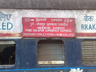
The 22105/22106 Indrayani Express is a superfast express train belonging to Indian Railways that runs between Mumbai CST and Pune Junction in India.
Khadki Railway Station or Khadki Station is on the Mumbai - Pune Railway route. It is owned by central railways department of Indian Railways. Sinhagad Express, Sahyadri Express, Deccan Express, Koyna Express and Mumbai - Chennai Express have their halt at this station. It has four platforms, six lines and one footbridge and is an electrified station. The nearest railway station is Pune Railway Station and nearest airport is Pune International Airport at Lohegaon. The Pichola offers accommodation which is just 4 km away from the station. This is a Major halt for Military. This makes this an important station on Pune Suburban Railway. This station is to the east of Khadki Auto Rickshaw Stand and is near Khadki Bazaar. This Station was built for access to Khadki Cantonment. Even today this station is mostly used for Indian Army. The CAFVD Sports Stadium is in front of this railway station which hosts local Association Football and Field Hockey matches.

Karjat is a railway station on the Central line of the Mumbai Suburban Railway network. Karjat is a major rail terminus, connected via local trains to Chhatrapati Shivaji Terminus Mumbai, Khopoli and Panvel.

Panvel is a railway station on the Harbour Line and Central zone of the Mumbai Suburban Railway network.
Kashele is a village near the city of Karjat, in the state of Maharashtra, India. The village is located 82 km from Mumbai, and its official language is Marathi.
Dhalwadi is a small village in Karjat Taluka in Ahmednagar district of Maharashtra State, India. It belongs to the Khandesh and Northern Maharashtra regions. It is located 80 kilometers south from the district headquarters of Ahmednagar and 272 km from Mumbai.
Poshir is a village near the city of Neral, in the state of Maharashtra, India.
Sadapur (Marathi:सैदापूर) is a village in India. It is situated in the Mawal taluka of Pune District in the state of Maharashtra.
Ruigavhan is a village in the Ahmednagar District of Maharashtra, India. It is the only village in the Ruigavhan gram panchayat. Ruigavhan is 66.0 km from the main city, Ahmednagar, 124 km from Pune and 272 km from the state capital, Mumbai. The nearest towns are Shrigonda (20.3 km), Karjat (23.4 km), Bhigwan (53.8 km), and Jamkhed (54.3 km)
Tungi fort is a small 16th-century fort probably mainly used as a lookout post in the past. It is situated to the east of Karjat in the Indian state of Maharashtra. It is one of the easy-to-reach forts near the Bhimashanker trek route in the Karjat area.