Montezuma, Moctezuma, Moteczoma, Motecuhzoma, Moteuczomah, Muteczuma and Mwatazuma are variant spellings of the same word and may refer to:
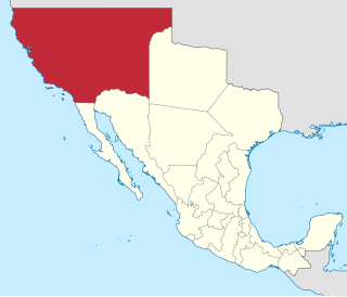
Alta California, known sometimes unofficially as Nueva California, California Septentrional, California del Norte or California Superior, began in 1804 as a province of New Spain. Along with the Baja California peninsula, it had previously comprised the province of Las Californias, but was split off into a separate province in 1804. Following the Mexican War of Independence, it became a territory of Mexico in April 1822 and was renamed "Alta California" in 1824. The claimed territory included all of the modern US states of California, Nevada and Utah, and parts of Arizona, Wyoming, Colorado and New Mexico. In the 1836 Siete Leyes government reorganization, the two Californias were once again combined - into a single departamento. That change was undone in 1846, but rendered moot by U.S. military occupation of California in the Mexican-American War.
The Western United States is the region comprising the westernmost states of the United States. As European settlement in the U.S. expanded westward through the centuries, the meaning of the term the West changed. Before about 1800, the crest of the Appalachian Mountains was seen as the western frontier. The frontier moved westward and eventually the lands west of the Mississippi River were considered the West.

ThePacific Coast Ranges, are the series of mountain ranges that stretch along the West Coast of North America from Alaska south to Northern and Central Mexico.
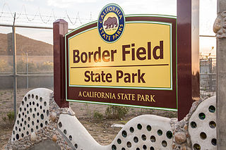
Border Field State Park is a state park of California, United States, containing beach and coastal habitat on the Mexico–United States border. The park is within the city limits of Imperial Beach in San Diego County, next to the suburb of Playas de Tijuana in Mexico. It contains the southernmost point in the state of California. The refuge forms the southern part of the Tijuana River National Estuarine Research Reserve.
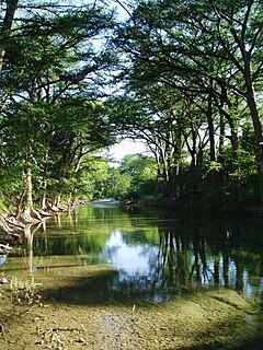
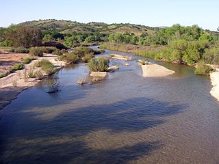
The Medina River is located in south central Texas, United States, in the Medina Valley. It was also known as the Rio Mariano, Rio San Jose, or Rio de Bagres. Its source is in springs in the Edwards Plateau in northwest Bandera County, Texas and merges with the San Antonio River in southern Bexar County, Texas, for a course of 120 miles. It contains the Medina Dam in NE Medina County, Texas which restrains Lake Medina. Much of its course is owned and operated by the Bexar-Medina-Atascosa Water District to provide irrigation services to farmers and ranches.
San Antonio is the seventh-most populous city in the United States and the second-most populous in the state of Texas.

The Old Spanish Trail is a historical trade route that connected the northern New Mexico settlements of Santa Fe, New Mexico with those of Los Angeles, California and southern California. Approximately 700 mi (1,100 km) long, the trail ran through areas of high mountains, arid deserts, and deep canyons. It is considered one of the most arduous of all trade routes ever established in the United States. Explored, in part, by Spanish explorers as early as the late 16th century, the trail saw extensive use by pack trains from about 1830 until the mid-1850s.
El Pueblo de Nuestra Señora la Reina de los Ángeles, shortened to Pueblo de los Ángeles, was the Spanish civilian pueblo founded in 1781, which by the 20th century became the American metropolis of Los Angeles.

Joseph Rodman West was a United States Senator from Louisiana, a union general in the United States Army during and after the American Civil War and the Chief Executive of the District of Columbia. As a commander of militia, he gave the order to torture and murder Apache chief Mangas Coloradas who had come to meet with him under a flag of truce to discuss terms of peace. He also allowed the decapitation and desecration of the body.

Fiesta Noche del Rio is a seasonal outdoor performance which features the songs and dances of Mexico, Spain, Argentina, and the U.S. states of California and Texas.

San Timoteo Canyon is a river valley canyon southeast of Redlands, in the far northwestern foothills of the San Jacinto Mountains in the Inland Empire region of Southern California.
Rancho Los Medanos was a 8,859-acre (35.85 km2) Mexican land grant in present-day Contra Costa County, California given in 1839 by Governor Juan Alvarado to Jose Antonio Mesa and Jose Miguel Garcia. The name "los medanos" is derived from the sand hills located along the San Joaquin River on its northern boundary. Rancho Los Medanos was located at the junction of the San Joaquin River and the Sacramento River, extending eastward along the south shore of Suisun Bay to Antioch. The rancho lands included present-day Antioch and Pittsburg.
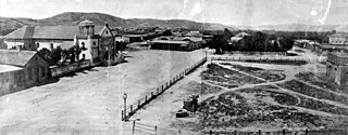
The City of San Antonio is one of the oldest Spanish colonization of the European settlements in Texas and was, for decades, its largest city. Before Spanish colonization, the site was occupied for thousands of years by varying cultures of indigenous peoples. The historic Payaya Indians were likely those who encountered the first Europeans.
In the American Old West overland trails were popular means of travel used by pioneers and immigrants throughout the 19th century and especially between 1830 and 1870 as an alternative to sea and railroad transport. These immigrants began to settle North America west of the Great Plains as part of the mass overland migrations of the mid-19th century. Settlers emigrating from the eastern United States were spurred by various motives, among them religious persecution and economic incentives. After the end of the Mexican–American War in 1849, vast new American conquests again enticed mass immigration. Legislation like the Donation Land Claim Act and significant events like the California Gold Rush further lured people to travel overland to the west.

Southern Emigrant Trail, also known as the Gila Trail, the Kearny Trail, Southern Trail and the Butterfield Stage Trail, was a major land route for immigration into California from the eastern United States that followed the Santa Fe Trail to New Mexico during the California Gold Rush. Unlike the more northern routes, pioneer wagons could travel year round, mountain passes not being blocked by snows, however it had the disadvantage of summer heat and lack of water in the desert regions through which it passed in New Mexico Territory and the Colorado Desert of California. Subsequently, it was a route of travel and commerce between the eastern United States and California. Many herds of cattle and sheep were driven along this route and it was followed by the San Antonio-San Diego Mail Line in 1857-1858 and then the Butterfield Overland Mail from 1858 - 1861.