Santa Carolina

Last updated
Santa Carolina
Nickname: Paradise Island
Mozambique adm location map.svg
Red pog.svg
Africa location map.svg
Red pog.svg
Geography
Location Indian Ocean
Archipelago Bazaruto Archipelago
Length2 mi (3 km)
Width0.3 mi (0.5 km)
Administration
Mozambique
Province Inhambane
District Inhassoro

Coordinates: 21°37′08″S35°20′28″E / 21.619°S 35.341°E / -21.619; 35.341

Geographic coordinate system Coordinate system

A geographic coordinate system is a coordinate system that enables every location on Earth to be specified by a set of numbers, letters or symbols. The coordinates are often chosen such that one of the numbers represents a vertical position and two or three of the numbers represent a horizontal position; alternatively, a geographic position may be expressed in a combined three-dimensional Cartesian vector. A common choice of coordinates is latitude, longitude and elevation. To specify a location on a plane requires a map projection.

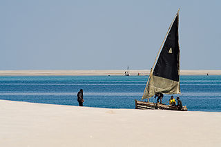
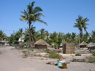
Santa Carolina is an island between the Mozambican mainland and Bazaruto Island in Mozambique. The closest town is called Inhassoro. It is just 2 by 0.3 miles (3.22 km × 0.48 km) in size. Santa Carolina is a true rock island with deep channels. Santa Carolina has three beaches with coral reefs close to the shore. The island, also known as Paradise Island is regarded as the ‘gem’ of the islands forming the Bazaruto Archipelago which is a proclaimed marine national park.

Island Any piece of sub-continental land that is surrounded by water

An island or isle is any piece of sub-continental land that is surrounded by water. Very small islands such as emergent land features on atolls can be called islets, skerries, cays or keys. An island in a river or a lake island may be called an eyot or ait, and a small island off the coast may be called a holm. A grouping of geographically or geologically related islands is called an archipelago, such as the Philippines.

Mozambique country in Africa

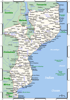
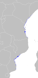
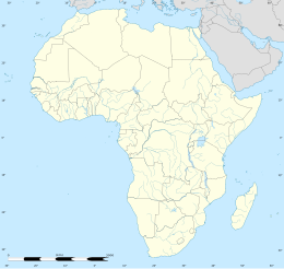
Mozambique, officially the Republic of Mozambique, is a country located in Southeast Africa bordered by the Indian Ocean to the east, Tanzania to the north, Malawi and Zambia to the northwest, Zimbabwe to the west, and Eswatini (Swaziland) and South Africa to the southwest. The sovereign state is separated from the Comoros, Mayotte and Madagascar by the Mozambique Channel to the east. The capital of Mozambique is Maputo while Matola is the largest city, being a suburb of Maputo.

Bazaruto Archipelago archipelago in Mozambique

The Bazaruto Archipelago is a group of six islands in Mozambique, near the mainland city of Vilankulo. It comprises the islands of Bazaruto, Benguerra, Magaruque, Banque, Santa Carolina and Shell. Nyati Island locates in further south.

The island was used for season 3 of Survivor South Africa (titled Survivor South Africa: Santa Carolina ).

<i>Survivor South Africa</i> television series

Survivor South Africa is a South African reality game show based on the popular international Survivor format.

<i>Survivor South Africa: Santa Carolina</i>

Survivor South Africa: Santa Carolina is the third season of the South African reality game show Survivor South Africa. The season was filmed in late 2009 and aired weekly between January and April 2010 on Wednesdays nights on M-Net with the ninety-minute live season finale airing on the 21, April 2010. M-Net also commissioned a 15th episode that had a look at the whole series with retrospective views from all the contestants. Hosted by Nico Panagio, the program featured 18 celebrity castaways competing for 27 days. The grand prize was a R500,000 donation to the winner's chosen charity and an additional R500,000 for the winner.


Related Research Articles

Geography of Mozambique

Mozambique is located on the east coast of southern Africa. Mozambique has a tropical climate with two seasons, a wet season from October to March and a dry season from April to September.

Lee County, South Carolina county in South Carolina, United States

Lee County is a county located in the U.S. state of South Carolina. As of the 2016 census, its population was 17,635, making it the fifth-least populous county in South Carolina. Its county seat is Bishopville. The county is named for Confederate General Robert E. Lee. A previous incarnation of Lee County was established in 1898 and was disestablished the next year. The current Lee County was formed in 1902.

Beaufort County, South Carolina county in South Carolina, USA

Beaufort County is a county in the U.S. state of South Carolina. As of the 2010 census, its population was 162,233. Its county seat is Beaufort.

Hyde County, North Carolina county in North Carolina, United States

Hyde County is a county located in the U.S. state of North Carolina. As of the 2010 Census, the population was 5,810, making it the second-least populous county in North Carolina. Its county seat is Swan Quarter. The county was created in 1705 as Wickham Precinct. It was renamed Hyde Precinct in 1712 and gained county status in 1739.

Avery Creek, North Carolina Census-designated place in North Carolina, United States

Avery Creek is a census-designated place (CDP) in Buncombe County, North Carolina, United States. The population was 1,950 at the 2010 census. It is part of the Asheville Metropolitan Statistical Area.

Parris Island, South Carolina Former CDP in South Carolina, United States

Parris Island is a former census-designated place (CDP) in Beaufort County, South Carolina, United States. The population was 4,841 at the 2000 census. As defined by the U.S. Census Bureau, Parris Island is included within the Beaufort Urban Cluster and the larger Hilton Head Island–Beaufort Micropolitan Statistical Area. The area was annexed by the town of Port Royal on October 11, 2002.

Olanta, South Carolina Town in South Carolina, United States

Olanta is a town in Florence County, South Carolina, United States. The population was 563 at the 2010 census, down from 613 in 2000. It is part of the Florence Metropolitan Statistical Area.

Inhassoro Place in Inhambane Province, Mozambique

Inhassoro is a small fishing port in Inhassoro District of Inhambane Province in Mozambique. The town has 11,297 inhabitants and is located on the Indian Ocean coast along the EN1 highway.

Bazaruto Island island

Bazaruto is a sandy island located approximately 80 kilometres (50 mi) southeast of the mouth of the Save River, Mozambique. It is the largest island in the Bazaruto Archipelago and in the Bazaruto National Park.

Algoa Bay

Algoa Bay is a bay in the Eastern Cape, South Africa. It is located in the east coast, 425 miles east of the Cape of Good Hope.

Magaruque Island island in Mozambique

Magaruque Island, formerly Ilha Santa Isabel, is part of the Bazaruto Archipelago, off the coast of Mozambique. It is located 5.6 km south of Benguerra Island, and 9.9 km east of Ponta Chuè on the mainland of Mozambique.

Santa Elena, a Spanish settlement on what is now Parris Island, South Carolina, was the capital of Spanish Florida from 1566 to 1587. It was established under Pedro Menéndez de Avilés, the first governor of Spanish Florida. There had been a number of earlier attempts to establish colonies in the area by both the Spanish and the French, who had been inspired by earlier accounts of the plentiful land of Chicora. Menéndez's Santa Elena settlement was intended as the new capital of the Spanish colony of La Florida, shifting the focus of Spanish colonial efforts north from St. Augustine, which had been established in 1565 to oust the French from their colony of Fort Caroline. Santa Elena was ultimately built at the site of the abandoned French outpost of Charlesfort, founded in 1562 by Jean Ribault.

Inhassoro District District in Inhambane, Mozambique

Inhassoro District is a district of Inhambane Province in south-east Mozambique. The district is located at the northeast of the province, and borders with Govuro District in the north, Vilanculos District in the southeast, Massinga District in the south, Funhalouro District in the southwest, and with Mabote District in the west. In the east, the district is bounded by the Indian Ocean. The area of the district is 4,480 square kilometres (1,730 sq mi). It has a population of 48,537 as of 2007.

Vilanculos District District in Inhambane, Mozambique

Vilankulo District or Vilanculos District is a district of Inhambane Province in south-east Mozambique. Its principal town is Vilankulo. The district is located at the east of the province, and borders with Inhassoro District in the north and Massinga District in the south and in the west. In the east, the district is bounded by the Indian Ocean. The area of the district is 5,867 square kilometres (2,265 sq mi). It has a population of 135,710 as of 2007.

Benguerra Island in Mozambique is the second largest island in the Bazaruto Archipelago, which broke away from the mainland thousands of years ago. The island is approximately 55 square kilometers, and lies 14km offshore. Portuguese explorers also gave the island the name Santa Antonio. It is famous for its unspoiled white beaches, dive sites,luxury resorts, horseback riding and fishing.

East African mangroves An ecoregion of mangrove swamps along the Indian Ocean coast of East Africa in Mozambique, Tanzania, Kenya and southern Somalia

East African mangroves are an ecoregion consisting of mangrove swamps along the Indian Ocean coast of East Africa in southern Mozambique, Tanzania, Kenya and southern Somalia.

Bazaruto National Park national park

The Bazaruto National Park (BANP) is a protected area in the Inhambane Province of Mozambique on the Bazaruto Archipelago. The park was proclaimed on 25 May 1971. It is off the coast of the Vilanculos and Inhassoro districts, covering a large expanse of ocean and six islands.