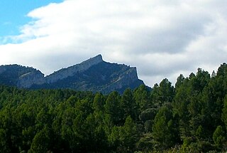
Serra de Pàndols

Last updated
Serra de Pàndols

Serradepandols20.JPG

Serra de Pàndols seen from Hill 705
Highest point
Elevation 705 m (2,313 ft)
Coordinates 41°01′13.68″N00°27′27.88″E / 41.0204667°N 0.4577444°E / 41.0204667; 0.4577444 Coordinates: 41°01′13.68″N00°27′27.88″E / 41.0204667°N 0.4577444°E / 41.0204667; 0.4577444
Geography
Catalonia location map.svg
Red triangle with thick white border.svg
Serra de Pàndols
Catalonia, Spain
Location Terra Alta, Spain
Parent range Catalan Pre-Coastal Range
Geology
Mountain type Limestone
Climbing
Easiest route Drive from Gandesa or El Pinell de Brai

Serra de Pàndols is a limestone mountain chain located at the southern end of the Catalan Pre-Coastal Range, in Catalonia, Spain. [1]

Limestone Sedimentary rocks made of calcium carbonate

Limestone is a sedimentary rock which is often composed of the skeletal fragments of marine organisms such as coral, foraminifera, and molluscs. Its major materials are the minerals calcite and aragonite, which are different crystal forms of calcium carbonate (CaCO3).

Catalan Pre-Coastal Range system of mountain ranges running parallel to the Mediterranean Sea coast in Catalonia

The Catalan Pre-Coastal Range is a system of mountain ranges running parallel to the Mediterranean Sea coast in Catalonia. It is part of the Catalan Mediterranean System. Its main axis runs between the Catalan Transversal Range and the Serra de l'Espina, which connects with the Ports de Tortosa-Beseit, part of the Iberian System. The highest point is 1.706,7 m at the Montseny Massif.

Catalonia Autonomous area of northeastern Spain

Catalonia is an autonomous community in Spain on the northeastern corner of the Iberian Peninsula, designated as a nationality by its Statute of Autonomy. Catalonia consists of four provinces: Barcelona, Girona, Lleida, and Tarragona. The capital and largest city is Barcelona, the second-most populated municipality in Spain and the core of the sixth most populous urban area in the European Union. It comprises most of the territory of the former Principality of Catalonia. It is bordered by France (Occitanie) and Andorra to the north, the Mediterranean Sea to the east, and the Spanish autonomous communities of Aragon to the west and Valencia to the south. The official languages are Catalan, Spanish, and the Aranese dialect of Occitan.

Contents

There is a project to install wind turbines on the Serra de Pàndols and neighboring Serra de Cavalls which has met with public protests. [2] The Serra de Paüls mountain range is located to the south of this range.

Wind turbine device that converts wind energy into mechanical and electric energy

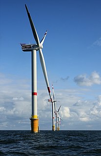
A wind turbine, or alternatively referred to as a wind energy converter, is a device that converts the wind's kinetic energy into electrical energy.

Serra de Cavalls mountain in Spain

Serra de Cavalls is a mountain chain located at the southern end of the Catalan Pre-Coastal Range, Catalonia, Spain. The ridge's highest point is Punta Redona. This mountain range lies within the Benissanet, Gandesa and El Pinell de Brai municipal term. On the northern side are two ridges of parallel foothills called Serra del Pebre and Serra de Santa Madrona. Its northern prolongation is known as Serra de la Vall de la Torre.

Serra de Paüls mountain in Spain

Serra de Paüls is a mountain range in the northern side of the Ports de Tortosa-Beseit, Catalonia, Spain. The highest summit, Punta de l'Aigua has an elevation of 1,091.6 metres above sea level.

Hill 705

The ridge's highest point is Punta Alta (705.5 m). This summit was known as Hill 705 (Cota 705) during the Battle of the Ebro, the bloodiest and most protracted series of combats in the Spanish Civil War (1936–39). The Battle was also the last action of the International Brigades, who were withdrawn midway through it.

The Battle of the Ebro was the longest and largest battle of the Spanish Civil War. It took place between July and November 1938, with fighting mainly concentrated in two areas on the lower course of the Ebro River, the Terra Alta comarca of Catalonia, and the Auts area close to Fayón (Faió) in the lower Matarranya, Eastern Lower Aragon. These sparsely populated areas saw the largest array of armies in the war. The results of the battle were disastrous for the Second Spanish Republic, with tens of thousands of dead and wounded and little effect on the advance of the Nationalists.

Spanish Civil War War between the Republicans and the Nationalists in Spain from 1936 to 1939

The Spanish Civil War took place from 1936 to 1939. Republicans loyal to the left-leaning Second Spanish Republic, in alliance with the Anarchists and Communists, fought against the Nationalists, a Falangist, Carlist, Catholic, and largely aristocratic group led by General Francisco Franco. The war was known as a struggle between democracy and fascism, particularly due to the international political climate. The Nationalists won the war in early 1939 and ruled Spain until Franco's death in November 1975.

International Brigades paramilitary supporting the Republicans in the Spanish Civil War

The International Brigades were paramilitary units set up by the Communist International to assist the Popular Front government of the Second Spanish Republic during the Spanish Civil War. The organisation existed for two years, from 1936 until 1938. It is estimated that during the entire war, between 32,000 and 35,000 members served in the International Brigades, including 15,000 who died in combat; however, there were never more than 20,000 brigade members present on the front line at one time.

Close to the peak stands a monument to those who died in the battles. [3] Hill 705 was a key position to control the Serra de Pàndols range at the time of the Battle of the Ebro. The summit lies within the Pinell de Brai municipal term.

Bronze plaque honoring the British volunteer soldiers of the International Brigades who died in combat on cota 705. Britishv-cota705.JPG
Bronze plaque honoring the British volunteer soldiers of the International Brigades who died in combat on cota 705.
Monument to those who died defending the Spanish Republic in the battles located on Hill 705 Monument-cota705.JPG
Monument to those who died defending the Spanish Republic in the battles located on Hill 705

See also

11th Division (Spain) Spain

The 11th Division was a division of the Spanish Republican Army in the Spanish Civil War. It was formed in January 1937 in Madrid beginning with the 1st Mixed Brigade which in turn had originated in the Fifth Regiment.

Related Research Articles

Terra Alta (comarca) Comarca in Catalonia, Spain

Terra Alta is a sparsely populated inland comarca (county) in Catalonia, Spain. Its capital is Gandesa. It is also known as Castellania, a name dating back to its medieval status as a fiefdom held by the Order of Knights of the Hospital of St. John of Jerusalem under the Crown of Aragon.

Ascó Municipality in Catalonia, Spain

Ascó is a large village in the comarca of Ribera d'Ebre, Catalonia, Spain, on the right bank of the Ebre river at the feet of the Serra de la Fatarella range. The village of Ascó is known for its nuclear power station, and for excellent fishing in the river.

Ports de Tortosa-Beseit mountain

Ports de Tortosa-Beseit, also known as Ports de Beseit, or simply as Els Ports[əls ˈpɔɾts] or Lo Port[lu ˈpɔɾt] by locals, is a limestone mountain massif located at the north-eastern end of the Sistema Ibérico, a complex system of mountain ranges and massifs in the centre of the Iberian Peninsula. Its highest point is Mont Caro, 1,441 m. Rivers such as the Matarranya and the Sénia have their source in these mountains.

Serra de Montsant mountain range

Serra de Montsant is a mountain chain in Catalonia, Spain. The main populated area in the range is La Morera de Montsant.

Corbera dEbre Municipality in Catalonia, Spain

Corbera d'Ebre is a municipality in the comarca of la Terra Alta in Catalonia, Spain. It is one of the 12 municipalities comprising the wine-growing region of the Spanish Denominación de Origen classification of the Spanish wine Terra Alta.

El Pinell de Brai Municipality in Catalonia, Spain

El Pinell de Brai is a municipality in the comarca of la Terra Alta in Catalonia, Spain.

Auts

Auts is a mountain range west of the Ebro river in the Bajo Aragón-Caspe/Baix Aragó-Casp comarca, Aragon, Spain.

Serra dels Pesells mountain in Spain

Serra dels Pesells is a mountain chain located near the southern end of the Catalan Pre-Coastal Range between Bot and Arenys de Lledó. The ridge's highest point is 541,3 m. This smooth range runs in a NNE - SSW direction and divides the basins of the Canaletes and Algars rivers. It is one of the isolated hills of the Catalan Central Depression and it is located at its southwestern end.

Catalan Central Depression

The Catalan Central Depression is a natural depression between the Pre-Pyrenees and the Catalan Pre-Coastal Range in Spain. It widens towards the west, linking with the Ebro Depression, Catalan: Depressió de l'Ebre, of which it could be considered an eastern extension. The Catalan Central Depression is about 180 km long with an average width of 50 km.

Ebro Delta

The Ebro Delta is the delta region of the Ebro River, in the Province of Tarragona, Catalonia, in northeastern Spain. It is on the Mediterranean Sea, and is the northernmost point, by some designations, of the Gulf of Valencia. Its location per Ramsar site designation is 40°43′N0°44′E.

Turó de la Mamella mountain in Spain

Turó de la Mamella is a mountain of Catalonia, Spain. Located in the Terrassa and Vacarisses municipal limits, it is one of the foothills of the Serra de l'Obac, Catalan Pre-Coastal Range, and has an elevation of 806.6 metres above sea level.

Cardó Massif

The Cardó Massif, also known as Cardó-Boix Massif, is a mountain massif in the Baix Ebre comarca, in Catalonia, Spain. This massif is composed of a number of mountain ranges located on the left side of the Ebro river near Tortosa. The massive calcareous cliffs of the Serra de Cardó form the eastern side of the spectacular gorges through which the Ebro River winds its way in the final stage of its course, separating the Ebro Valley from the Mediterranean coastal area.

Serra de la Fatarella mountain in Spain

Serra de la Fatarella is one of the isolated mountain ranges of the Catalan Central Depression located off the southern end of the Catalan Pre-Coastal Range between La Fatarella and Ascó in Spain. The ridge's highest point is 563.5 m; another important summit is 552 m high Punta de l'Home. This smooth range runs in a N - S direction.

The Siege of Gandesa took place between July and November 1938 during the Spanish Civil War, a few months after a battle in the same town.

226th Mixed Brigade (Spain)

The 226th Mixed Brigade, was a mixed brigade of the Spanish Republican Army in the Spanish Civil War. Part of its forces had belonged to the former Bautista Garcet Battalion, which had distinguished itself in the combats of the Córdoba offensive at the beginning of the Civil War. Its formation began in August 1937 in Catalonia, but it was delayed for a long time, the brigade not becoming fully operational until 1938. It had four battalions, the 901, 902, 903 and 904.

Serra de la Vall de la Torre

Serra de la Vall de la Torre, also known as Serra de la Vall, is a mountain range located at the southern end of the Catalan Pre-Coastal Range, Catalonia, Spain. The ridge's highest point is 450.8 m. This mountain range lies within the Benissanet and Corbera d'Ebre municipal term. It is a smaller and lower northern prolongation of the Serra de Cavalls.

Mount Picossa mountain in Spain

Mount Picossa is a mountain in Catalonia, Spain. It is located within the Móra d'Ebre municipal limits, Ribera d'Ebre.

References

  1. "Mapa Topogràfic de Catalunya". Institut Cartogràfic de Catalunya. Retrieved 9 September 2010.
  2. Edmon Castell i Oriol Nel·lo El parc eòlic de les Serres de Pàndols i Cavalls. Energia, valors ambientals i memòria històrica (Ed.). 2003. Aquí, No! Els conflictes territorials a Catalunya. Barcelona: Editorial Empúries.
  3. The Battle of the Ebro in one day Archived 2011-07-19 at the Wayback Machine .

Bibliography

International Standard Book Number Unique numeric book identifier

The International Standard Book Number (ISBN) is a numeric commercial book identifier which is intended to be unique. Publishers purchase ISBNs from an affiliate of the International ISBN Agency.