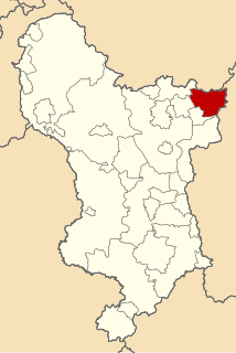
South East Derbyshire was a rural district in Derbyshire, England from 1894 to 1974. It covered an area to the south-east of Derby.
Rural districts were a type of local government area – now superseded – established at the end of the 19th century in England, Wales, and Ireland for the administration of predominantly rural areas at a level lower than that of the administrative counties.

Derbyshire is a county in the East Midlands of England. A substantial portion of the Peak District National Park lies within Derbyshire, containing the southern extremity of the Pennine range of hills which extend into the north of the county. The county contains part of the National Forest, and borders on Greater Manchester to the northwest, West Yorkshire to the north, South Yorkshire to the northeast, Nottinghamshire to the east, Leicestershire to the southeast, Staffordshire to the west and southwest and Cheshire also to the west. Kinder Scout, at 636 metres (2,087 ft), is the highest point in the county, whilst Trent Meadows, where the River Trent leaves Derbyshire, is its lowest point at 27 metres (89 ft). The River Derwent is the county's longest river at 66 miles (106 km), and runs roughly north to south through the county. In 2003 the Ordnance Survey placed Church Flatts Farm at Coton in the Elms as the furthest point from the sea in Great Britain.

England is a country that is part of the United Kingdom. It shares land borders with Wales to the west and Scotland to the north-northwest. The Irish Sea lies west of England and the Celtic Sea lies to the southwest. England is separated from continental Europe by the North Sea to the east and the English Channel to the south. The country covers five-eighths of the island of Great Britain, which lies in the North Atlantic, and includes over 100 smaller islands, such as the Isles of Scilly and the Isle of Wight.
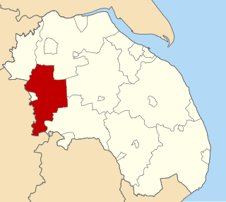
It was formed as Shardlow rural district under the Local Government Act 1894, mainly from the Derbyshire part of the Shardlow rural sanitary district (the Leicestershire part becoming Castle Donington Rural District, and most of the Nottinghamshire part becoming Stapleford Rural District).

The Local Government Act 1894 was an Act of the Parliament of the United Kingdom that reformed local government in England and Wales outside the County of London. The Act followed the reforms carried out at county level under the Local Government Act 1888. The 1894 legislation introduced elected councils at district and parish level.

Shardlow is a village in Derbyshire, England about 6 miles (9.7 km) southeast of Derby and 11 miles (18 km) southwest of Nottingham. Part of the civil parish of Shardlow and Great Wilne, and the district of South Derbyshire, it is also very close to the border with Leicestershire, defined by route of the River Trent which passes close to the south. Just across the Trent is the Castle Donington parish of North West Leicestershire.

Leicestershire is a landlocked county in the English Midlands. The county borders Nottinghamshire to the north, Lincolnshire to the north-east, Rutland to the east, Northamptonshire to the south-east, Warwickshire to the south-west, Staffordshire to the west, and Derbyshire to the north-west. The border with most of Warwickshire is Watling Street.
It also administered the parishes of Ratcliffe on Soar and Kingston on Soar in Nottinghamshire - these became part of Leake Rural District in 1927.

Kingston on Soar is a village and civil parish in the Rushcliffe borough of Nottinghamshire, England.

Nottinghamshire is a county in the East Midlands region of England, bordering South Yorkshire to the north-west, Lincolnshire to the east, Leicestershire to the south, and Derbyshire to the west. The traditional county town is Nottingham, though the county council is based in West Bridgford in the borough of Rushcliffe, at a site facing Nottingham over the River Trent.
Leake was a rural district in Nottinghamshire, England from 1894 to 1935.
The district was renamed South East Derbyshire in 1959. It was abolished under the Local Government Act 1972, with the parishes of Breadsall, Breaston, Dale Abbey, Draycott and Church Wilne, Hopwell, Little Eaton, Morley, Ockbrook, Risley, Sandiacre, Stanley, Stanton by Dale and West Hallam going on to form part of the new Erewash district, with the rest becoming part of a new South Derbyshire district.
The Local Government Act 1972 is an Act of the Parliament of the United Kingdom that reformed local government in England and Wales on 1 April 1974.

Breadsall is a village and civil parish in the English county of Derbyshire, grid reference SK370397. The population of the civil parish at the 2011 census was 773. Breadsall Priory is nearby.

Breaston is a large village and civil parish in the Erewash district, in the south-east of Derbyshire in the East Midlands of England near Long Eaton and close to the M1. The population of the civil parish as taken at the 2011 Census was 4,455.