St. Abbs and Eyemouth Voluntary Marine Reserve

Last updated

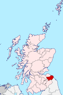
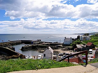
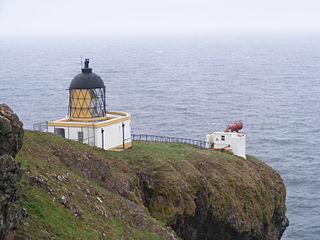
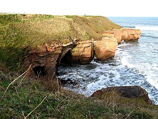
St. Abbs and Eyemouth Voluntary Marine Reserve is a Voluntary Marine Reserve—the first established in the United Kingdom. Located in the Scottish Borders, it covers 8 km of the Berwickshire coast, from Eyemouth in the south to St. Abb's Head in the north. At its centre is the fishing village of St. Abbs.

United Kingdom Country in Europe

The United Kingdom, officially the United Kingdom of Great Britain and Northern Ireland but more commonly known as the UK or Britain, is a sovereign country lying off the north-western coast of the European mainland. The United Kingdom includes the island of Great Britain, the north-eastern part of the island of Ireland and many smaller islands. Northern Ireland is the only part of the United Kingdom that shares a land border with another sovereign state‍—‌the Republic of Ireland. Apart from this land border, the United Kingdom is surrounded by the Atlantic Ocean, with the North Sea to the east, the English Channel to the south and the Celtic Sea to the south-west, giving it the 12th-longest coastline in the world. The Irish Sea lies between Great Britain and Ireland. With an area of 242,500 square kilometres (93,600 sq mi), the United Kingdom is the 78th-largest sovereign state in the world. It is also the 22nd-most populous country, with an estimated 66.0 million inhabitants in 2017.

Scotland country in Northwest Europe, part of the United Kingdom

Scotland is a country that is part of the United Kingdom. Sharing a border with England to the southeast, Scotland is otherwise surrounded by the Atlantic Ocean to the north and west, by the North Sea to the northeast and by the Irish Sea to the south. In addition to the mainland, situated on the northern third of the island of Great Britain, Scotland has over 790 islands, including the Northern Isles and the Hebrides.

Scottish Borders Council area of Scotland

The Scottish Borders is one of 32 council areas of Scotland. It borders the City of Edinburgh, Dumfries and Galloway, East Lothian, Midlothian, South Lanarkshire, West Lothian and, to the south-west, south and east, the English counties of Cumbria and Northumberland. The administrative centre of the area is Newtown St Boswells.

The reserve is one of the most popular scuba diving locations in the United Kingdom. The water of the reserve is unusually clear, in contrast to the more silt-laden coastal waters further to the north or south. The reserve was opened on 18 August 1984 by David Bellamy.

Silt is granular material of a size between sand and clay, whose mineral origin is quartz and feldspar. Silt may occur as a soil or as sediment mixed in suspension with water and soil in a body of water such as a river. It may also exist as soil deposited at the bottom of a water body, like mudflows from landslides. Silt has a moderate specific area with a typically non-sticky, plastic feel. Silt usually has a floury feel when dry, and a slippery feel when wet. Silt can be visually observed with a hand lens, exhibiting a sparkly appearance. It also can be felt by the tongue as granular when placed on the front teeth.

David Bellamy English professor, botanist, author, broadcaster and environmental campaigner

David James Bellamy OBE is an English author, broadcaster, environmental campaigner and botanist. He has lived in County Durham since 1960.

Coordinates: 55°53′57″N2°07′46″W / 55.89917°N 2.12944°W / 55.89917; -2.12944

Geographic coordinate system Coordinate system

A geographic coordinate system is a coordinate system that enables every location on Earth to be specified by a set of numbers, letters or symbols. The coordinates are often chosen such that one of the numbers represents a vertical position and two or three of the numbers represent a horizontal position; alternatively, a geographic position may be expressed in a combined three-dimensional Cartesian vector. A common choice of coordinates is latitude, longitude and elevation. To specify a location on a plane requires a map projection.

Related Research Articles

Berwickshire Historic county in Scotland

Berwickshire is a historic county, registration county and lieutenancy area in the Scottish Borders. It takes its name from Berwick-upon-Tweed, which was part of Scotland at the time of the county's formation, but became part of England in 1482.

Eyemouth town

Eyemouth is a small town and civil parish in Berwickshire, in the Scottish Borders area of Scotland. It is 2 miles (3.2 km) east of the main north-south A1 road and just 8 miles (13 km) north of Berwick-upon-Tweed. It has a population of about 3,420 people (2004).

Lavender Pit

The Lavender Pit is a former open pit copper mine near Bisbee in Cochise County, Arizona, United States. It is located near the famous Copper Queen Mine. The Lavender Pit was named in honor of Harrison M. Lavender (1890–1952), who as Vice-President and General Manager of Phelps Dodge Corporation, conceived and carried out this plan for making the previously unprofitable low-grade copper bearing rock of the area into commercial copper ore.

Granite Mountains (Wyoming)

The Granite Mountains are a short subrange of the Rocky Mountains in central Wyoming of the United States. The range runs approximately 100 mi (160 km) E-W along the south side of the Shoshone Basin, and north of the Sweetwater River, in eastern Fremont County and western Natrona County. The highest point is McIntosh Peak at 8,058 feet (2,456 m). Independence Rock is at the east end of the range, and Split Rock was a prominent landmark on the Oregon Trail. The region is rich in uranium and other mineral deposits.

Brokopondo District District in Suriname

Brokopondo is a district of Suriname. Its capital city is Brokopondo; other towns include Brownsweg and Kwakoegron.

St Abbs village in United Kingdom

St Abbs is a small fishing village on the southeastern coast of Scotland, within the Coldingham parish of Berwickshire.

St Abbs Head

St Abb's Head is a rocky promontory by the village of St Abbs in Berwickshire, Scotland, and a national nature reserve administered by the National Trust of Scotland.

Marine nature reserve (MNR) is a conservation designation officially awarded by a government to a marine reserve of national significance.

Craigroyston F.C.

Craigroyston Football Club are a Scottish football club based in Edinburgh, who play their home matches at St Mark's Park in the Warriston area of the city. The team competes in the East of Scotland Football League, having moved from the junior leagues in 2018.

Eyemouth disaster

The Eyemouth disaster was a severe European windstorm that struck the south-eastern coast of Scotland, United Kingdom, specifically Berwickshire, on 14 October 1881. One hundred and eighty-nine fishermen, most of whom were from the village of Eyemouth, were drowned. Many citizens of Eyemouth call the day Black Friday.

Cove, Scottish Borders village in United Kingdom

Cove is a village in the Scottish Borders area of Scotland, close to Cockburnspath, Dunglass, Innerwick, Oldhamstocks, Bilsdean, and, further afield, Dunbar and Eyemouth. It is approximately 36 miles east of Edinburgh and is about 8 miles from Dunbar. It is 18 miles north-west from the Scotland/England border.

HMS <i>St Vincent</i> (Whitehall shore establishment)

HMS St Vincent was a shore establishment of the Royal Navy, located in London during the 1990s.

This page is a list of fishing topics.

Coldingham Bay

Coldingham Bay is an inlet in the North Sea coast, just over three kilometres north of the town of Eyemouth in the Scottish Borders area of Scotland. It is situated at grid reference NT918666 and is easily reached by a minor road which leaves the B6438 road at Coldingham.

Ross is a hamlet on the coast of the Scottish Borders area of Scotland, south of Burnmouth, in the parish of Ayton, and close to the A1.

HMS <i>Ascension</i>

HMS Ascension (K502) was a Colony-class frigate of the United Kingdom that served in the Royal Navy during World War II. She originally was ordered by the United States Navy as the Tacoma-class frigate USS Hargood (PF-74) and was transferred to the Royal Navy prior to completion.

St Abbs Lifeboat Station lifeboat station in Berwickshire, Scotland

St Abbs Lifeboat is an independent marine-rescue facility in St Abbs, Berwickshire, Scotland.

Berwickshire Coastal Path

The Berwickshire Coastal Path is a walking route some 48 kilometres (30 mi) long. It follows the eastern coastline of Scotland from Cockburnspath in the Scottish Borders to Berwick upon Tweed, just over the border in England. At Cockburnspath the path links with the Southern Upland Way and the John Muir Way.

Marshall Meadows Bay bay and northernmost point of England

Marshall Meadows Bay is the northernmost point of England. It is located on the Northumberland coast, 2.5 miles (4.0 km) to the north of Berwick-upon-Tweed, and just to the south of the Anglo-Scottish border. Across the border in Scotland is the county of Berwickshire in the Borders region. The hamlet of Marshall Meadows lies to the west of the bay, and is the most northerly inhabited place in England. The Marshall Meadows Country House Hotel is here, along with a farm and a caravan site. There is a disused tunnel from the caravan site to the bay below. Nearby is the A1 trunk road and the East Coast Main Line railway.