A tributary or affluent is a stream or river that flows into a larger stream or main stem river or a lake. A tributary does not flow directly into a sea or ocean. Tributaries and the main stem river drain the surrounding drainage basin of its surface water and groundwater, leading the water out into an ocean.
The Passaic River is a river, approximately 80 mi (129 km) long, in northern New Jersey in the United States. The river in its upper course flows in a highly circuitous route, meandering through the swamp lowlands between the ridge hills of rural and suburban northern New Jersey, called the Great Swamp, draining much of the northern portion of the state through its tributaries. In its lower portion, it flows through the most urbanized and industrialized areas of the state, including along downtown Newark. The lower river suffered from severe pollution and industrial abandonment in the 20th century. In April 2014, the U.S. Environmental Protection Agency announced a $1.7 billion plan to remove 4.3 million cubic yards of toxic mud from the bottom of lower eight miles of the river. It is considered one of the most polluted stretches of water in the nation and the project one of the largest clean-ups ever undertaken.
Hawthorne is a borough in Passaic County, New Jersey, United States. As of the 2010 United States Census, the borough's population was 18,791 reflecting an increase of 573 (+3.1%) from the 18,218 counted in the 2000 Census, which had in turn increased by 1,134 (+6.6%) from the 17,084 counted in the 1990 Census.
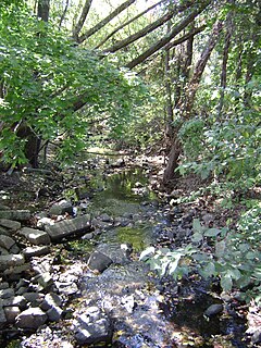
Stevenson Brook is one half mile long and once flowed unobstructed from the Diamond Bridge Avenue area of Hawthorne south to the Passaic River, but a significant section of the brook was culvertized early in the twentieth century. Two portions of the brook now remain intact at the surface, running from Diamond Bridge Avenue to Royal Avenue and from Wagaraw Road to the Passaic River. The section south of Wagaraw Road is crossed by a pedestrian bridge linking a parking lot to a local sports complex.
A culvert is a structure that allows water to flow under a road, railroad, trail, or similar obstruction from one side to the other side. Typically embedded so as to be surrounded by soil, a culvert may be made from a pipe, reinforced concrete or other material. In the United Kingdom, the word can also be used for a longer artificially buried watercourse.
There is a residential development along Stevenson Brook called Diamond Brook Hollow. The name of the development seems to be derived from a local tendency to refer to Stevenson Brook as Diamond Brook, because it is crossed by Diamond Bridge Avenue. However, the real Diamond Brook (40°56′47″N74°08′32″W / 40.946487°N 74.142137°W / 40.946487; -74.142137) lies about a half mile to the east in the towns of Glen Rock and Fair Lawn.
Diamond Brook, also known as Bass Brook, is a tributary of the Passaic River which flows south through a section of Bergen County in New Jersey, United States. Heading up the brook from the Passaic River, one encounters the boroughs of Fair Lawn and Glen Rock, as well as the village of Ridgewood.
Glen Rock is a borough in Bergen County, New Jersey, United States. As of the 2010 United States Census, the borough's population was 11,601, reflecting an increase of 55 (+0.5%) from the 11,546 counted in the 2000 Census, which had in turn increased by 663 (+6.1%) from the 10,883 counted in the 1990 Census.
Fair Lawn is a borough in Bergen County, New Jersey, United States, and a suburb located 10 miles (16 km) from New York City. As of the 2010 United States Census, the borough's population was 32,457, reflecting an increase of 820 (+2.6%) from the 31,637 counted in the 2000 Census, which had in turn increased by 1,089 (+3.6%) from the 30,548 counted in the 1990 Census.
A small stream that once flowed parallel to the Passaic River known as De Gray Brook connected into Stevenson Brook just north of its junction with the Passaic River. De Gray Brook was completely filled in with the construction of the Wagaraw Sports Complex.
A geographic coordinate system is a coordinate system that enables every location on Earth to be specified by a set of numbers, letters or symbols. The coordinates are often chosen such that one of the numbers represents a vertical position and two or three of the numbers represent a horizontal position; alternatively, a geographic position may be expressed in a combined three-dimensional Cartesian vector. A common choice of coordinates is latitude, longitude and elevation. To specify a location on a plane requires a map projection.
This page is based on this Wikipedia article Text is available under the CC BY-SA 4.0 license; additional terms may apply. Images, videos and audio are available under their respective licenses.
Related Research Articles
The First River, in the state of New Jersey in the United States, is a subterranean river and the first main tributary of the Passaic River encountered while travelling upstream from its mouth at Newark Bay.
The Rockaway River is a tributary of the Passaic River, approximately 35 mi (56 km) long, in northern New Jersey in the United States. The upper course of the river flows through a wooded mountainous valley, whereas the lower course flows through the populated New Jersey suburbs and former industrial area west of New York City. It drains an area of approximately 130 sq mi (340 km²).
The Main Line is a rail line owned and operated by New Jersey Transit running from Suffern, New York to Hoboken, New Jersey, in the United States. It runs daily commuter service and was once the north-south main line of the Erie Railroad. It is colored yellow on NJ Transit system maps, and its symbol is a water wheel.
The Bergen County Line is a commuter rail line and service owned and operated by New Jersey Transit in the U.S. state of New Jersey. The line loops off the Main Line between the Meadowlands and Glen Rock, with trains continuing in either direction along the Main Line. It is colored on NJT system maps in pale blue, and its symbol is a cattail.
Conrail's Passaic and Harsimus Line serves freight in northeastern New Jersey, as an alternate to the mainly passenger Northeast Corridor. It takes trains from the Northeast Corridor and Lehigh Line near Newark Liberty International Airport northeast and east into Jersey City, New Jersey, serving as part of CSX's main corridor from upstate New York to the rest of the east coast.
Broadway is an unincorporated community and neighborhood within the city of Newark in Essex County, New Jersey, United States. It is located on the west bank of the Passaic River, in Newark's North Ward, east of Forest Hill and north of Seventh Avenue. The neighborhood extends from Interstate 280 to Belleville. The term "Broadway" has only come into use recently, most Broadway residents simply refer to their area as part of the North Ward. The street itself "Broadway" was called "Washington Avenue" until the early twentieth century. Today, the area is predominantly Italian American and Puerto Rican, with a growing population from other parts of Latin America. The New Jersey Historical Society was located here from the 1930s to 1997. The neo-classical Mutual Benefit building was constructed in the Broadway neighborhood in 1927. The district has many old brownstones in various states of repair. There are high-rise apartment buildings overlooking Branch Brook Park.
The Millstone River is a 38.6-mile-long (62.1 km) tributary of the Raritan River in central New Jersey in the United States.
Goffle Brook is a tributary of the Passaic River which flows south through a section of Passaic County and Bergen County in New Jersey and drains the eastern side of the First Watchung Mountain. Heading up the brook from the confluence with the Passaic River, one encounters the borough of Hawthorne, the village of Ridgewood, the borough of Midland Park, and the township of Wyckoff.
Little Diamond Brook is a tributary of the Passaic River which flows south through a section of Bergen County in New Jersey. Heading up the approximately two mile long brook from the Passaic River, one encounters the towns of Fair Lawn and Glen Rock.
Paterson Plank Road is a road that runs through Passaic, Bergen and Hudson Counties in northeastern New Jersey originally lain in the colonial era. The route, connecting the city Paterson and the Hudson River waterfront, still exists. It has largely been superseded by Route 3, but in the many towns it passes it has remained an important local thoroughfare, and in some cases been renamed.
Salt Brook is a tributary of the Passaic River in Union County, New Jersey in the United States.
South Kearny is an industrial district and distinct area of Hudson County, New Jersey at the northern end of Newark Bay in the town of Kearny, New Jersey. It is on the larger peninsula once called New Barbadoes Neck, which also include the other Kearny districts of the Uplands and the Kearny Meadows. It has been known as Kearny Point and, along Droyer's Point in Jersey City, marks the mouth of the Hackensack River to the east. The Passaic River flows along its western border opposite a similarly industrial portion of the Ironbound district of Newark. Most of the point is part of Foreign-Trade Zone 49
The West Essex Trail is an Essex County park, situated on the former right-of-way of the Caldwell Branch of the old Erie-Lackawanna Railroad, in Verona, New Jersey, and Cedar Grove, New Jersey. Distinguishing features of this rail trail include a trestle bridge 20 feet (6m) above the Peckman River, and the abandoned Essex County Hospital Center.
Goffle Brook Park is a public, county park spanning much of the length of Goffle Brook through the borough of Hawthorne in Passaic County, New Jersey, United States. Since its designation and construction between 1930 and 1932, the park has served to protect the waters of Goffle Brook while at the same time providing recreational opportunities to the residents of Passaic County and nearby Bergen County. Goffle Brook Park has been included in the National Register of Historic Places since 2002.
Goffle Hill, also referred to as Goffle Mountain and historically known as Totoway Mountain and Wagaraw Mountain, is a range of the trap rock Watchung Mountains on the western edge of the Newark Basin in northern New Jersey. The hill straddles part of the border of Bergen County and Passaic County, underlying a mostly suburban setting. While hosting patches of woodlands, perched wetlands, and traprock glades, the hill is largely unprotected from development. Extensive quarrying for trap rock has obliterated large tracts of the hill in North Haledon, and Prospect Park. Conservation efforts seeking to preserve undeveloped land, such as the local Save the Woods initiative (2007–present), are ongoing.
The Newark and New York Railroad was a passenger rail line that ran between Downtown Newark and the Communipaw Terminal at the mouth of the North River in Jersey City, bridging the Hackensack River and Passaic River just north of their mouths at the Newark Bay in northeastern New Jersey. The Central Railroad of New Jersey operated it from its opening in 1869. Through operation ended in 1946; portions remained in use until 1967.
Black Brook is a tributary of the Passaic River that flows through the Great Swamp National Wildlife Refuge in Morris County, New Jersey, in the United States. Black Brook rises at the north east base of Long Hill, Chatham Township, Morris County, flows westerly along the hill, by a course of 7 or 8 miles to its recipient in Morris Township, New Jersey. Due to the chemical fertilizer usage in nearby areas, Black Brook has the second worst water quality after Loantaka Brook.
McDonald's Brook is tributary of the Passaic River. It is a natural stream originating in Clifton, New Jersey, passing through Passaic, New Jersey. For most of its length, it runs underground in a culvert constructed by the United States Army Corps of Engineers. Prior to the construction of the culvert, larger parts of it ran through a ground-level stream bed, though parts of it ran underground even in its natural configuration.