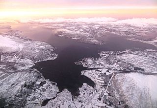
Rennesøy is an island municipality in Rogaland county, Norway. It is located in the traditional district of Ryfylke. The administrative centre of the municipality is the village of Vikevåg. Other villages in Rennesøy include Askje and Sørbø. The municipality encompasses a number of islands on the south side of the Boknafjorden, north of the city of Stavanger.

Hinnøya is the fourth largest island in Norway. The 2,204.7-square-kilometre (851.2 sq mi) lies just off the western coast of Northern Norway. The island sits on the border of Nordland and Troms counties. The western part of the island is in the district of Vesterålen, the southwestern part is in the Lofoten district, the southeastern part is in the Ofoten district, and the northeastern part is in Southern Troms.
Senja (Norwegian) or Sážžá (Northern Sami) is an island and future municipality in Troms county, Norway. At 1,586.3-square-kilometre (612.5 sq mi), it is the second largest island in Norway. It has a wild, mountainous outer (western) side facing the Atlantic, and a mild and lush inner (eastern) side. The island is governed by four municipalities: Torsken, Tranøy, Lenvik, and Berg, however in on 1 January 2020, the four municipalities are scheduled to be merged into one large Senja Municipality. The island of Senja had 7,864 inhabitants as of 1 January 2017. Most of the residents live along the eastern coast of the island, with Silsand being the largest urban area on the island. The fishing village of Gryllefjord on the west coast has a summer-only ferry connection to the nearby island of Andøya: the Andenes–Gryllefjord Ferry.

Roan is a municipality in Trøndelag county, Norway. It is part of the Fosen region in the northern part of the county. The administrative centre of the municipality is the village of Roan. Other villages include Bessaker, Brandsfjord, and Hofstad.

Fosen is a traditional district in Trøndelag, consisting of the municipalities Osen, Roan, Åfjord, Bjugn, Ørland, Rissa, Agdenes, Snillfjord, Hemne, Hitra and Frøya. The district is dominated by forested valleys, lakes, coastal cliffs but also shallow areas, and in the interior mountains reaching up to 675 m elevation. The western coast has many skerries and some islands, such as Stokkøya in Åfjord. There are some good salmon rivers, and sea eagles and other sea birds are very common along the coast, notably on the shallow area near Ørland (Grandefjæra). The west coast has mild winters, and some locations receive on average more than 2,000 mm of precipitation per year. Part of the Scandinavian coastal conifer forests are located in the valleys of the peninsula, and smaller areas are classified as temperate rainforest with 67 nature reserves. The largest nature reserve is Øyenskavelen, with many nature types including undisturbed forest, some of it classified as rainforest.

The Åfjorden is a fjord in Trøndelag county, Norway. The 15-kilometre (9.3 mi) long fjord lies inside the municipality of Åfjord. The municipal center of Åfjord, Årnes, lies at the head of the fjord. The Åfjorden flows into the Lauvøyfjorden between the village of Lysøysundet and the island of Lauvøya, and then it flows out into the ocean.

Straumsetervatnet or Selavatnet is a lake on the border of the municipalities of Åfjord and Verran in Trøndelag county, Norway. The majority of the 4.72-square-kilometre (1.82 sq mi) lake lies in Verran, with the northwestern end of the lake partially lying in Åfjord. The village of Sela lies on the northern side of the lake and the village of Sandsetra at the southeastern end of the lake. The lake is one of the sources for the Folla river system which flows into the Trondheimsfjord at the village of Follafoss.
Å is a village in the municipality of Åfjord in Trøndelag county, Norway. The village is also called Årnes or Å i Åfjord or just Åfjord. It is the administrative center of the municipality. The village is located at the end of the Åfjorden, about 10 kilometres (6.2 mi) west of the village of By. The lake Stordalsvatnet lies just east of the village. The 3.25-square-kilometre (800-acre) village has a population (2017) of 1,188 which gives the village a population density of 366 inhabitants per square kilometre (950/sq mi). Åfjord Church is located in Å, just west of the Nordalselva river.

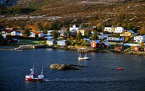
Stoksund is a former municipality in the old Sør-Trøndelag county, Norway. The municipality existed from 1892 until its dissolution in 1964. The 114-square-kilometre (44 sq mi) municipality was located in what is now the northwestern part of the municipality of Åfjord in Trøndelag county. The municipality included the island of Stokkøya and the surrounding islets, plus the surrounding area of the mainland. The administrative centre was the village of Revsnes, where the Stoksund Church is located.
Holsnøy is an island in Meland municipality, Hordaland county, Norway. The 88.8-square-kilometre (34.3 sq mi) island is the largest island in the municipality, and it makes up 98% of the land area of Meland municipality. The highest point on the island is the 324-metre (1,063 ft) tall Eldsfjellet, a mountain located about 2 kilometres (1.2 mi) north of the village of Rossland. The island is hilly and marshy, with the majority of the residents living along the southern shore. The largest settlement on the island is the village of Frekhaug on the southern shore. The island lies to the north/west of the mainland, between the islands of Radøy to the north and Askøy to the south.

Lauvøya is an island in the municipality of Åfjord in Trøndelag county, Norway. It is located about 4 kilometres (2.5 mi) northeast of the village of Lysøysundet, near the mouth of the Åfjorden.

Linesøya is an island in the municipality of Åfjord in Trøndelag county, Norway. It lies about 3 kilometres (1.9 mi) off the coast of the mainland of Åfjord, and 1 kilometre (0.62 mi) southwest of the island of Stokkøya. The 16.6-square-kilometre (6.4 sq mi) island also lies about 6.5 kilometres (4.0 mi) north of the smaller island of Lauvøya. The highest point on Linesøya is the 230-metre (750 ft) tall mountain Linesfjellet.
Stordalsvatnet is a lake in the municipality of Åfjord in Trøndelag county, Norway. The lake is located on the Stordalselva river which flows into the Åfjorden. The lake lies between the villages of By and Årnes.
Stoksund Church is a parish church in Ørland municipality in Trøndelag county, Norway. It is located in the village of Revsnes in the Stoksund area of Åfjord. The church is located right at the south end of the Stokkøy Bridge from the mainland to the island of Stokkøya. It is the church for the Stoksund parish which is part of the Fosen prosti (deanery) in the Diocese of Nidaros. The red, wooden church was built in a cruciform style in 1825 by the architects Ekr. Collet, O.G. Ebbe, and John Overdahl. The church seats about 200 people. It was consecrated on 10 July 1825 by Bishop Peder Olivarius Bugge.

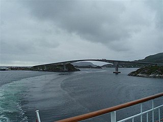
Linesøy Bridge is a cantilever bridge and causeway which connects the islands of Linesøya and Stokkøya in Åfjord, Norway. The bridge opened on 7 October 2011 and replaced the Kjerkholmen–Linesøy Ferry. The concrete bridge is 315-metre (1,033 ft) long.

Fosnøyna or Fosnøy is an island in the municipality of Austrheim in Hordaland county, Norway. The 26.3-square-kilometre (10.2 sq mi) island makes up the majority of the land area of the municipality. The island is located east of the Fedjefjorden and south of the Fensfjorden. The island of Radøy lies just south of Fosnøyna and the mainland of the Lindås peninsula lies immediately to the east of Fosnøyna. The highest point on the island is the 56-metre (184 ft) high Bredvikvarden. The island has some trees on it, but the northern part is fairly barren and rocky while the southern part is more marshy. There are two larger villages on the island: the village of Austrheim and the municipal centre of Årås. The island is connected to the mainland road network by two bridges. A series of small bridges connects Fosnøyna to the mainland of Lindås, west of Mongstad and the other connects the south end of Fosnøyna to the island of Radøy (which in turn is connected to the mainland.