Swansea Vale

Last updated

Swansea Vale (Welsh : Bro Abertawe) is a 160-acre (0.65 km2) mixed used new suburb development site in Swansea, Wales. The area is bounded east by Birchgrove; south by Swansea Enterprise Park, west by the River Tawe and north by the M4 motorway.

Welsh language Brythonic language spoken natively in Wales

Welsh or y Gymraeg is a member of the Brittonic branch of the Celtic languages. It is spoken natively in Wales, by some in England, and in Y Wladfa. Historically, it has also been known in English as "Cambrian", "Cambric" and "Cymric".

Swansea City & County in Wales

Swansea, is a coastal city and county, officially known as the City and County of Swansea in Wales. Swansea lies within the historic county boundaries of Glamorgan and the ancient Welsh commote of Gŵyr on the southwest coast. The county area includes Swansea Bay and the Gower Peninsula. Swansea is the second largest city in Wales and the twenty-fifth largest city in the United Kingdom. According to its local council, the City and County of Swansea had a population of 241,300 in 2014. The last official census stated that the city, metropolitan and urban areas combined concluded to be a total of 462,000 in 2011; the second most populous local authority area in Wales after Cardiff.

Wales Country in northwest Europe, part of the United Kingdom

Wales is a country that is part of the United Kingdom and the island of Great Britain. It is bordered by England to the east, the Irish Sea to the north and west, and the Bristol Channel to the south. It had a population in 2011 of 3,063,456 and has a total area of 20,779 km2 (8,023 sq mi). Wales has over 1,680 miles (2,700 km) of coastline and is largely mountainous, with its higher peaks in the north and central areas, including Snowdon, its highest summit. The country lies within the north temperate zone and has a changeable, maritime climate.

The development is a partnership between the City and County of Swansea council and the Welsh Assembly Government and will comprise a residential area (Tregof Village), a nature reserve and two business parks - Riverside Business Park and Central Business Park.

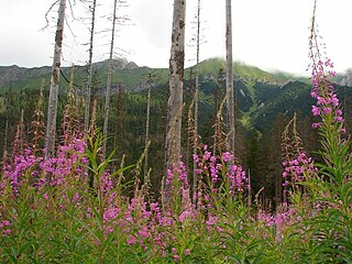
The Swansea Vale Nature Reserve consists of 6 hectares of land and is one of the few remaining areas of wetland habitat in Swansea. The reserve consists of woodland, rivers, ponds and marsh. The reserve is viewable by the public with a footpath and boardwalk built around the southern part of the reserve.

Wetland A land area that is permanently or seasonally saturated with water

A wetland is a distinct ecosystem that is inundated by water, either permanently or seasonally, where oxygen-free processes prevail. The primary factor that distinguishes wetlands from other land forms or water bodies is the characteristic vegetation of aquatic plants, adapted to the unique hydric soil. Wetlands play a number of functions, including water purification, water storage, processing of carbon and other nutrients, stabilization of shorelines, and support of plants and animals. Wetlands are also considered the most biologically diverse of all ecosystems, serving as home to a wide range of plant and animal life. Whether any individual wetland performs these functions, and the degree to which it performs them, depends on characteristics of that wetland and the lands and waters near it. Methods for rapidly assessing these functions, wetland ecological health, and general wetland condition have been developed in many regions and have contributed to wetland conservation partly by raising public awareness of the functions and the ecosystem services some wetlands provide.

Habitat ecological or environmental area inhabited by a particular species; natural environment in which an organism lives, or the physical environment that surrounds a species population

In ecology, a habitat is the type of natural environment in which a particular species of organism lives. It is characterized by both physical and biological features. A species' habitat is those places where it can find food, shelter, protection and mates for reproduction.

Woodland low-density forest forming open habitats with plenty of sunlight and limited shade

A woodland or wood is a low-density forest forming open habitats with plenty of sunlight and limited shade. Woodlands may support an understory of shrubs and herbaceous plants including grasses. Woodland may form a transition to shrubland under drier conditions or during early stages of primary or secondary succession. Higher density areas of trees with a largely closed canopy that provides extensive and nearly continuous shade are referred to as forests.

Related Research Articles

Gower (electoral ward) electoral ward in Swansea, UK

Gower electoral ward is an electoral ward in Britain. It is a ward of the City and County of Swansea, and comprises the western part of the Gower Peninsula. It lies within the UK Parliamentary constituency of Gower.

Neath Port Talbot county borough and unitary authority areas

Neath Port Talbot is a county borough and one of the unitary authority areas of Wales. Neath Port Talbot is the eighth most populous local authority area in Wales and the third most populous county borough. The actual population taken at the 2011 census was 139,812. The coastal areas are mainly English-speaking, however there are many Welsh-speaking communities in the Valleys to the north of the borough.

Bridgend County Borough county borough

Bridgend is a county borough in southern Wales, UK. The county borough has a total population of 139,200 people, and contains the settlements of Bridgend, after which it is named, Maesteg. Its members of the National Assembly for Wales are Carwyn Jones AM, the former First Minister of Wales and Huw Irranca-Davies AM representing the Ogmore Constituency, and its Members of Parliament are Madeleine Moon and Chris Elmore.

South Wales region of Wales

South Wales is the region of Wales bordered by England and the Bristol Channel to the east and south, mid Wales to the north, and west Wales to the west. With an estimated population of around 2.2 million, which is almost three-quarters of the whole of Wales, Cardiff has approximately 400,000, Swansea has approximately 250,000 and Newport has 150,000. The region is loosely defined, but it is generally considered to include the historic counties of Glamorgan and Monmouthshire, extending westwards to include Carmarthenshire and Pembrokeshire. In the western extent, from Swansea westwards, local people would probably recognise that they lived in both south Wales and west Wales. The Brecon Beacons national park covers about a third of South Wales, containing Pen y Fan, the highest British mountain south of Cadair Idris in Snowdonia.

River Tawe river in Wales, United Kingdom

The River Tawe is a river in the south of Wales. It flows in a principally southwesterly direction for some 48 km (30 mi) from its source below Moel Feity in the Old Red Sandstone hills of the western Brecon Beacons to the Bristol Channel at Swansea. Its main tributaries are the right bank Upper and Lower Clydach Rivers and the Afon Twrch. The total area of the catchment is some 246 km2. The Tawe passes through a number of towns and villages including Ystradgynlais, Ystalyfera, Pontardawe, and Clydach and meets the sea at Swansea Bay below Swansea. The Tawe Valley is more commonly known as the Swansea Valley.

Sketty (electoral ward) human settlement in United Kingdom

Sketty is the name of an electoral ward in the City and County of Swansea, Wales, UK. The electoral ward is coterminous with the community.

Maritime Quarter

The Maritime Quarter is a residential area of Swansea, Wales, UK located immediately south of the city centre shopping core. It falls within Swansea's Castle ward. The area is bounded by Brynmill to the west, Swansea Bay to the South, the River Tawe to the east and the A4067 to the north.

Landore (electoral ward)

Landore is the name of an electoral ward in the City and County of Swansea, Wales, UK.

Killay is the name of a suburb and local government community in Swansea, Wales. Killay has its own community council. The village is set high above sea level, about 3.5 miles west of Swansea city centre.

South West Wales

South West Wales is a region of Wales. A definition consisting of the unitary authorities of Swansea, Neath Port Talbot, Pembrokeshire and Carmarthenshire is used by a number of government agencies and private organisations including:

The Swansea Enterprise Park is a combined business park, retail park and industrial estate in Swansea, Wales. In 1981 it became the first enterprise zone in the United Kingdom, and the largest. Originally it was named the Swansea Enterprise Zone. The designated area covers parts of the Llansamlet and Morriston wards in the Lower Swansea valley, Wales. The Enterprise Park is the largest commercial district and the largest out-of-town shopping district of Swansea. Major employers at the site include Morganite, Alberto-Culver, Viskase, The Land Registry and Welsh Water.

Quadrant Shopping Centre

The Quadrant Shopping Centre is the principal under-cover shopping centre in Swansea, Wales. The centre opened in 1979. Since the 1980s it has been home to the Swansea Devil, a controversial carved wooden statue of the Devil.

Crymlyn Burrows is an area of land in Wales, UK to the east of Swansea city centre, and south of Crymlyn Bog. It is bounded by Jersey Marine Beach to the south and the River Neath to the east. The land west of Baldwin's Crescent falls within the City and County of Swansea and from Baldwin's Crescent eastwards falls within Neath Port Talbot.

The City and County of Swansea is an urban centre with a largely rural hinterland in Gower; the city has been described as the regional centre for South West Wales. Swansea's Travel to Work Area, not coterminous with the local authority, also contained the Swansea Valley in 1991; the new 2001-based version merges the Swansea, Neath & Port Talbot, and Llanelli areas into a new Swansea Bay Travel to Work Area. Formerly an industrial centre, most employment in the city is now in the service sector.

Morriston (electoral ward)

Morriston ( ) is an electoral ward in Swansea, Wales. It is coterminous with the Morriston community. Morriston is one of two five member wards in the City and County of Swansea local authority area. In population terms, it is the largest ward in the Welsh Assembly constituency of Swansea East and it is the largest ward the City and County of Swansea.

Bishop's Wood is a nature reserve in the Gower Peninsula, south Wales.

Morfa is a district of Swansea, Wales. It straddles the Bon-y-maen and Landore wards and generally covers the eastern part of the district of Landore.

SA1 Swansea Waterfront

SA1 Swansea Waterfront is the marketing name given to the brownfield development area located in northern part of Swansea Docks. The area is located directly to the southeast of Swansea city centre. It is bordered by the Fabian Way to the north and covers the Prince of Wales Dock area.

The Swansea Bay area of Wales is located north of the sea area of Swansea Bay. The term Swansea Bay is used by the Welsh Assembly Government for policy planning purposes as well as by a number of other organisations.

Protected areas of Wales

Many parts of Wales are protected areas, according to a number of designations. They include three national parks, and five Areas of Outstanding Natural Beauty.

References

Coordinates: 51°40′12″N3°54′03″W / 51.67000°N 3.90083°W / 51.67000; -3.90083

Geographic coordinate system Coordinate system

A geographic coordinate system is a coordinate system that enables every location on Earth to be specified by a set of numbers, letters or symbols. The coordinates are often chosen such that one of the numbers represents a vertical position and two or three of the numbers represent a horizontal position; alternatively, a geographic position may be expressed in a combined three-dimensional Cartesian vector. A common choice of coordinates is latitude, longitude and elevation. To specify a location on a plane requires a map projection.