The History of the Dividing Line

Last updated
Marker noting the passing of William Byrd II and company surveying the Dividing Line, 1728, Henry County, Virginia William Byrd's Camp November 1728 Historic Marker Henry County Virginia.JPG
Marker noting the passing of William Byrd II and company surveying the Dividing Line, 1728, Henry County, Virginia

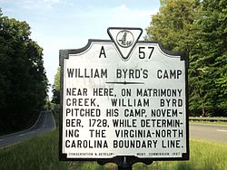
The History of the Dividing Line Betwixt Virginia and North Carolina is an account by William Byrd II of the surveying of the border between the Colony of Virginia and the Province of North Carolina in 1728. Byrd's account of the journey to survey the contentious border with his chief surveyor William Mayo included such nuggets as the derivation of the name of "Matrimony Creek," so named because of its 'brawling' waters.

William Byrd II American planter

William Byrd II was an American planter and author from Charles City County in colonial Virginia. He is considered the founder of Richmond, Virginia.

Colony of Virginia English/British possession in North America (1607-1776)

The Colony of Virginia, chartered in 1606 and settled in 1607, was the first enduring English colony in North America, following failed proprietary attempts at settlement on Newfoundland by Sir Humphrey Gilbert in 1583, and the subsequent further south Roanoke Island by Sir Walter Raleigh in the late 1580s.

Each of the two colonies provided surveyors and technicians to the team. William Byrd was the chief representative from Virginia, and Edward Moseley was the chief representative from North Carolina. Byrd also compiled what he called a Secret History of the project.

Edward Moseley, was the Surveyor General of the Province of North Carolina before 1710 and 1723 to 1733. He was also the first colonial Treasurer of North Carolina, starting in 1715. He was responsible, with William Byrd II of Virginia Colony, for surveying the boundary between North Carolina and Virginia in 1728.

William Byrd II's text was the focus of David Gatten's film project, also titled The Secret History of the Dividing Line.

David Gatten American film director

David Edward Gatten is an American experimental filmmaker and moving image artist. Since 1996 Gatten's films have explored the intersection of the printed word and moving image, cataloging the variety of ways in which texts functions in cinema as both language and image, often blurring the boundary between these categories. His 16mm films often employee cameraless techniques, combined with close-up cinematography and optical printing processes. In addition to the ongoing 16mm films, Gatten is now making hybrid 16mm/digital works and has completed an entirely digital feature-length project called The Extravagant Shadows.

Related Research Articles

Mason–Dixon line surveyed border line between U.S. states of Delaware, Maryland, and Pennsylvania

The Mason–Dixon line, also called the Mason and Dixon line or Mason's and Dixon's line, was surveyed between 1763 and 1767 by Charles Mason and Jeremiah Dixon in the resolution of a border dispute involving Maryland, Pennsylvania, and Delaware in Colonial America. It is still a demarcation line among four U.S. states, forming part of the borders of Pennsylvania, Maryland, Delaware, and West Virginia. Later it became known as the border between the Northern United States and the Southern United States. Before the Missouri Compromise, the line marked the northern limit of slavery in the United States.

Edenton, North Carolina Town in North Carolina, United States

Edenton is a town in and the county seat of Chowan County, North Carolina, United States, on Albemarle Sound. The population was 5,004 at the 2010 census. Edenton is located in North Carolina's Inner Banks region. In recent years Edenton has become a popular retirement location and a destination for heritage tourism.

The Carolinas Region

The Carolinas are the U.S. states of North Carolina and South Carolina, considered collectively. They are bordered by Virginia to the north, Tennessee to the west, and Georgia to the southwest. The Atlantic Ocean is to the east. Combining North Carolina's Clusters population of 10,042,802 and South Carolina's of 4,896,146, the Carolinas have a population of 14,938,948 as of 2015. If the Carolinas were a single state of the United States, it would be the fifth-most populous state, behind California, Texas, Florida, and New York. The Carolinas were known as the Province of Carolina during America's early colonial period, from 1663 to 1710. Prior to that, the land was considered part of the Colony and Dominion of Virginia, from 1609 to 1663. The province, named Carolina to honor King Charles I of England, was divided into two colonies in 1729, although the actual date is the subject of debate.

Peter Jefferson was the father of US President Thomas Jefferson (1743–1826). A surveyor and cartographer, his "Fry-Jefferson Map" of 1751—created in collaboration with Joshua Fry—accurately depicted the Allegheny Mountains for the first time and showed the route of "The Great Road from the Yadkin River through Virginia to Philadelphia distant 455 Miles"—what would later come to be known as the Great Wagon Road.

Fairfax Stone Historical Monument State Park

Fairfax Stone Historical Monument State Park is a West Virginia state park commemorating the Fairfax Stone, a surveyor's marker and boundary stone at the source of the North Branch of the Potomac River. The original stone was placed on October 23, 1746 to settle a boundary dispute between Thomas Fairfax, 6th Lord Fairfax of Cameron and the English Privy Council concerning the Northern Neck of Virginia. It determined the proprietorship and boundaries of a large tract of mostly unsurveyed land in the English colonies of Maryland and Virginia.

Dan River river in the U.S. states of North Carolina and Virginia

The Dan River flows 214 miles (344 km) in the U.S. states of North Carolina and Virginia. It rises in Patrick County, Virginia, and crosses the state border into Stokes County, North Carolina. It then flows into Rockingham County. From there it goes back into Virginia. It reenters North Carolina near the border between Caswell County and Rockingham County. It flows into northern Caswell County and then back into southern Virginia and finally into Kerr Reservoir on the Roanoke River.

The Saponi or Sappony are a Native American tribe historically based in the Piedmont of North Carolina and Virginia. They spoke the Siouan Tutelo-Saponi language, which was related to the languages of the Tutelo, Occaneechi, Monacan, Manahoac and other eastern Siouan peoples. Reduced by disease and warfare, the surviving members of the tribe migrated north to merge with other tribes. They disappeared from the historic record as a tribe by the end of the 18th century and were considered extinct as a tribe.

Albemarle Settlements

The Albemarle Settlements were the first permanent English settlements in what is now North Carolina, founded in the Albemarle Sound and Roanoke River regions, beginning about the middle of the 17th century. The settlers were mainly Virginians migrating south.

Edward Hyde (Governor of North-Carolina) first Governor of North-Carolina

Edward Hyde was a British colonial official who served as the first Governor of North-Carolina from 24 January 1712 until his death. He governed during a time of tremendous turmoil, including an internal revolt known as Cary's Rebellion and an American indian uprising called the Tuscarora War.

Smith River (Virginia) river in Virginia and North Carolina, United States. Tributary of the Dan River

The Smith River is a river in the U.S. states of Virginia and North Carolina. It is a tributary of the Dan River, which it joins at Eden, North Carolina. According to the United States Geological Survey, variant names are Irvin River, Irvine River, and Smiths River.

Great Indian Warpath

The Great Indian Warpath (GIW)—also known as the Great Indian War and Trading Path, or the Seneca Trail—was that part of the network of trails in eastern North America developed and used by Native Americans which ran through the Great Appalachian Valley. The system of footpaths extended from what is now upper New York state to deep within Alabama. Various Indians traded and made war along the trails, including the Catawba, numerous Algonquian tribes, the Cherokee, and the Iroquois Confederacy. The British traders' name for the route was derived from combining its name among the northeastern Algonquian tribes, Mishimayagat or "Great Trail", with that of the Shawnee and Delaware, Athawominee or "Path where they go armed".

The Tennessee Valley Divide is the boundary of the drainage basin of the Tennessee River and its tributaries.

Joshua Fry American politician

Colonel Joshua Fry (1699–1754) was a surveyor, adventurer, mapmaker, soldier, and member of the House of Burgesses, the legislature of the colony of Virginia. He is best known for collaborating with Peter Jefferson, the father of future U.S. president Thomas Jefferson, on an influential map of Virginia in 1752, and being the immediate predecessor of George Washington as commanding officer of the Virginia Regiment, a key unit in the military developments that led to the outbreak of the French and Indian War.

James Pittillo was a Scots laborer and Jacobite rebel, who became a major landowner after being deported in 1716 to the Colony of Virginia. After completing service of his indenture, in 1726 Pittillo was granted 242 acres (1.0 km2) on Wagua Creek in Brunswick County, Virginia.

Royal Colonial Boundary of 1665

The Royal Colonial Boundary of 1665 marked the border between the Colony of Virginia and the Province of Carolina from the Atlantic Ocean westward across North America. The line follows the parallel 36°30′ north latitude that later became a boundary for several U.S. states as far west as the Oklahoma Panhandle, and also came to be associated with the Missouri Compromise of 1820.

Seven Ranges

The Seven Ranges was a land tract in eastern Ohio that was the first tract to be surveyed in what became the Public Land Survey System. The tract is 42 miles (68 km) across the northern edge, 91 miles (146 km) on the western edge, with the south and east sides along the Ohio River. It consists of all of Monroe, Harrison, Belmont and Jefferson, and portions of Carroll, Columbiana, Tuscarawas, Guernsey, Noble, and Washington County.

The Carolina Road or the "Old Carolina Road" are names for various sections of the Great Wagon Road and other routes in colonial America. "The 'Old Carolina Road', extending from Lancaster, Pennsylvania to the Yadkin Valley, was one of the most heavily traveled roads in eighteenth century America." Parts of the 180 mile long Journey Through Hallowed Ground National Heritage Area scenic byway follows the Old Carolina Road through Pennsylvania, Maryland and Virginia.

The North Carolina–Tennessee–Virginia Corners is a tripoint where the states of North Carolina, Tennessee and Virginia meet. Located in the Iron Mountains, the landmark is roughly equidistant between Snake Mountain to the south, and Mount Rogers,, to the northeast.

References