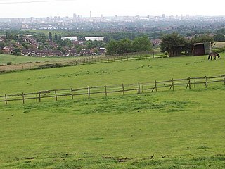
Great Barr is a large and loosely defined area in north-west Birmingham, England. The area was historically in Staffordshire, and the parts now in Birmingham were once known as Perry Barr, which is still the name of an adjacent Birmingham district.
Birmingham is the second-most populous city in the United Kingdom, after London, and the most populous city in the English Midlands. With an estimated population of 1,137,100 as of 2017, Birmingham is the cultural, social, financial and commercial centre of the Midlands. It is the main centre of the West Midlands conurbation, which is the third most populated urban area in the United Kingdom, with a population in 2011 of 2,440,986. The wider Birmingham metropolitan area is the second largest in the United Kingdom with a population of over 3.7 million. Birmingham is frequently referred to as the United Kingdom's "second city".
Walsall is a large industrialised market town in the West Midlands. Historically part of Staffordshire, it is located 8 miles (13 km) north-west of Birmingham, 6 miles (10 km) east of Wolverhampton and 9 miles (14 km) from Lichfield.
The canal passes through Tower Hill in a deep cutting in 200-million-year-old sandstone, and is crossed by Freeth Bridge (now restricted to pedestrians and bikes only). There are no locks on this section, which is at the Walsall Level.
The area was chiefly developed between 1930 and 1960 for a mix of private and council housing. It has shops, a medical centre, a library (venue for the Barr and Aston Local History Society) and an ambulance station; the latter in a former branch of the Birmingham Municipal Bank. The only pub, The Towers, boasts a sign carved by William Bloye.
The Birmingham Municipal Bank was a savings bank in the city of Birmingham, England. It was created as the Birmingham Corporation Savings Bank by a 1916 Act of Parliament, to raise money to aid World War I. It was the only municipal bank in the country.
William James Bloye was an English sculptor, active in Birmingham either side of World War II.
A geographic coordinate system is a coordinate system that enables every location on Earth to be specified by a set of numbers, letters or symbols. The coordinates are often chosen such that one of the numbers represents a vertical position and two or three of the numbers represent a horizontal position; alternatively, a geographic position may be expressed in a combined three-dimensional Cartesian vector. A common choice of coordinates is latitude, longitude and elevation. To specify a location on a plane requires a map projection.
This page is based on this Wikipedia article Text is available under the CC BY-SA 4.0 license; additional terms may apply. Images, videos and audio are available under their respective licenses.
Related Research Articles
The West Midlands is a metropolitan county and city region in western-central England with a 2014 estimated population of 2,808,356, making it the second most populous county in England after Greater London. It came into existence as a metropolitan county in 1974 after the passage of the Local Government Act 1972, formed from parts of Staffordshire, Worcestershire and Warwickshire. The county itself is a NUTS 2 region within the wider NUTS 1 region of the same name. The county consists of seven metropolitan boroughs: the City of Birmingham, the City of Coventry and the City of Wolverhampton, as well as the boroughs of Dudley, Sandwell, Solihull and Walsall.
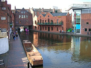
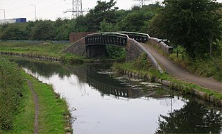
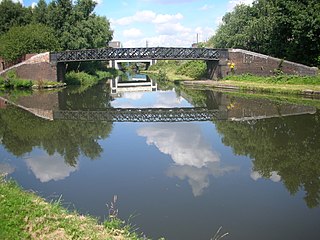
The Birmingham and Fazeley Canal is a canal of the Birmingham Canal Navigations in the West Midlands of England. Its purpose was to provide a link between the Coventry Canal and Birmingham and thereby connect Birmingham to London via the Oxford Canal.
Great Barr Hall is an 18th-century mansion situated at Pheasey, Walsall, on the border with Great Barr, Birmingham, West Midlands, England. It has associations with the Lunar Society and is a Grade II* listed building. It is, however, in a very poor state of repair and is on the Buildings at Risk Register.
Birmingham Canal Navigations (BCN) is a network of canals connecting Birmingham, Wolverhampton, and the eastern part of the Black Country. The BCN is connected to the rest of the English canal system at several junctions.
Perry Barr is a suburban area in north Birmingham, England. It is also the name of a council constituency, managed by its own district committee. Birmingham Perry Barr is also a parliamentary constituency; its Member of Parliament is Khalid Mahmood.
Sandwell Valley is an area of green belt in the West Midlands of England, on the border of Birmingham and West Bromwich, with Walsall at its northern end.
Gravelly Hill is an area of Birmingham, United Kingdom.
The Westside is a district of the city centre of Birmingham, England, which includes many new and planned buildings such as The Cube, Library of Birmingham and Regal Tower.
Ocker Hill is a residential area of Tipton in the West Midlands of England.
The Tame Valley Canal is a relatively late (1844) canal in the West Midlands of England. It forms part of the Birmingham Canal Navigations. It takes its name from the roughly-parallel River Tame.
The Anson Branch is a short canal in the West Midlands, England. It runs for just over one mile from its junction with the Walsall Canal near Forster's bridge. It forms part of the Birmingham Canal Navigations.
Pheasey is a residential area of Walsall Metropolitan Borough in the West Midlands of England, often considered to be part of Great Barr. The area was predominantly developed for housing, as the Pheasey Estate, in the 1930s, but work was not completed until after the Second World War. Barr Beacon, a hill, is a local landmark.
The Walsall Canal is a narrow canal, seven miles long, forming part of the Birmingham Canal Navigations, and passing around the western side of Walsall, West Midlands, England.
The Rushall Canal is a straight, 2.75-mile (4.43 km), narrow canal suitable for boats which are 7 feet (2.1 m) wide, forming part of the Birmingham Canal Navigations (BCN) on the eastern side of Walsall, West Midlands, England.
Rushall Junction is the southern limit of the Rushall Canal where it meets the Tame Valley Canal in the West Midlands, England. It opened in 1847, when the Rushall Canal was built to create connections between the Birmingham Canal Navigations system and the Wyrley and Essington Canal, following the amalgamation of the two companies in 1840.
Tame Valley Junction, also known as Doe Bank Junction, is a canal junction at the western limit of the Tame Valley Canal where it meets the Walsall Canal, south of Walsall, in the West Midlands, England.
Birchills Junction is the canal junction at the northern limit of what is now called the Walsall Canal where it meets the Wyrley and Essington Canal main line, near Walsall, West Midlands, England. It opened in 1798, but lasted for little more than a year, until it was re-opened in 1841 when a connecting link was built to the Birmingham Canal Navigations' southern route to Walsall.
Wednesbury Old Canal is part of the Birmingham Canal Navigations (BCN) in West Midlands (county), England. It opened in 1769, and although parts of it were abandoned in 1955 and 1960, the section between Pudding Green Junction and Ryder's Green Junction is navigable, as it provides a link to the Walsall Canal, while a short stub beyond Ryder's Green Junction is also navigable.
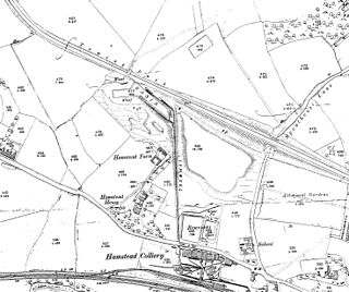
Hamstead Colliery in Hamstead, England, produced coal between 1878 and 1965, by mining the South Staffordshire 'Thick' coal seam. It suffered a major fire in 1908 in which 26 men died.