
Zynoviy Bohdan Khmelnytsky was a Ukrainian Hetman of the Zaporozhian Host of the Crown of the Kingdom of Poland in the Polish–Lithuanian Commonwealth. He led an uprising against the Commonwealth and its magnates (1648–1654) that resulted in the creation of a state led by the Cossacks of Ukraine. In 1654, he concluded the Treaty of Pereyaslav with the Tsardom of Russia.

The Cemetery of the Defenders of Lwów is a memorial and a burial place for the Poles and their allies who died in Lviv during the hostilities of the Polish-Ukrainian War and Polish-Soviet War between 1918 and 1920.

Petro Dorofeyevych Doroshenko was a Cossack political and military leader, Hetman of Right-bank Ukraine (1665–1672) and a Russian voyevoda.

The Tiasmyn river is a right tributary of the Dnieper River in Ukraine. The Tiasmyn originates in the north central part of the Dnieper hills in the central Ukrainian province of Kirovohrad. From there it flows through the Cherkasy Oblast, where it finally flows into the Kremenchuk Reservoir. The river forms a U-turn (180°) in its central run. Not counting the river's sharp turn, the river's source and its delta are located only 33 km (21 mi) away from each other.

Zmiiv is a city in Kharkiv Oblast (province) of Ukraine. Zmiiv is the administrative center of Zmiiv Raion.

Cigeľka is a village and municipality in Bardejov District in the Prešov Region of north-east Slovakia with Ruthenian and Roma inhabitants. It lies in the valley of Oľchovec below the Busov hill near the Slovakia-Poland border. There is a Greek Catholic church of Saints Cosmas and Damian in the year 1816, which served its first liturgy Presov later Bishop Paul Peter Gojdič.

Drobytsky Yar is a ravine in Kharkiv, Ukraine. In December 1941, Nazi troops invading the Soviet Union began killing local residents over the following year. At the end of this period, some 16,000 people, mainly Jews were killed. Notably on 15 December 1941, when the temperature was −15 degrees Celsius (+5 °F), ca. 15,000 Jews were shot. Children were thrown into pits alive, to save bullets, in the expectation that they would quickly freeze to death.
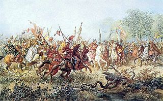
Battle of Korsuń, was the second significant battle of the Khmelnytsky Uprising. Near the site of the present-day city of Korsun-Shevchenkivskyi in central Ukraine, a numerically superior force of Cossacks and Crimean Tatars under the command of Hetman Bohdan Khmelnytsky and Tugay Bey attacked and defeated Polish-Lithuanian Commonwealth forces under the command of Hetmans Mikołaj Potocki and Marcin Kalinowski. As in the previous battle at Zhovti Vody, the outmanned Commonwealth forces took a defensive position, retreated, and were thoroughly routed by the opposing force.

Subotiv is a village (selo) in central Ukraine. It is located in the Chyhyryn Raion (district) of the Cherkasy Oblast (province), near Chyhyryn city.

Ivan Briukhovetsky was a hetman of Left-bank Ukraine from 1663 to 1668. In the early years of rule his was positioned as pro-Russian policies incited a rebellion which he later joined in an attempt to salvage his reputation and authority. Later leader of the Anti-Moscow uprising. His assessments as a rule differ in the part of Ukrainian historians which are supporters Petro Doroshenko.

The National Historical Commission of the Philippines is a government agency of the Philippines. Its mission is "the promotion of Philippine history and cultural heritage through research, dissemination, conservation, sites management and heraldry works." As such, it "aims to inculcate awareness and appreciation of the noble deeds and ideals of our heroes and other illustrious Filipinos, to instill pride in the Filipino people and to rekindle the Filipino spirit through the lessons of history."
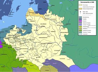
Ottoman Ukraine / Khan Ukraine is an historical term for right-bank Ukraine also known after its Turkic name Yedisan. The first mentioned records are traced to 1737 when the Russian secret agent Lupul was urging to attack the Ottoman Ukraine.

Historical markers are installed by the National Historical Commission of the Philippines (NHCP) in the Philippines and places abroad that signify important events, persons, structures, and institutions in Philippine national and local histories. The plaques themselves are permanent signs installed by the NHCP in publicly visible locations on buildings, monuments, or in special locations. Local municipalities and cities can also install markers of figures and events of local significance. Though they may have the permission of the NHCP, these markers are barred from using the seal of the Republic of the Philippines.

The ethnographic and tourist complex called Cossack Village and St. Nicolas Crush of 18 century is an open-air museum, created for the National Historical and Cultural Preserve "Chyhyryn", located in the village of Stetsivka.

Historical and hydrological memorial "Three Wells" is an open-air museum, created for the National Historical and Cultural Preserve "Chyhyryn", located in the Subotiv village. According to a legend, these three wells were sunk by order of Bogdan Khmelnytsky to honor joint struggle of Ukrainian, Russian and Belarusian people for independence during the war against Polish gentry. Local storytellers say that if someone thinks of three secret wishes and drinks some water from the three wells, the wishes will come true.
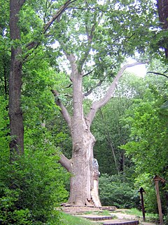
The Maksym Zaliznyak oak tree is a memorial to nature and history created for the National Historical and Cultural Preserve "Chyhyryn", located in the Buda village. The tree took 3rd prise in the "National Tree of Ukraine" national competition in 2010. Being over 1,100 year old, it is one of the oldest and biggest trees in Ukraine and Europe. It is named after Maksym Zaliznyak, a leader of the Koliyivshchyna rebellion of haidamaks in 1768. Its trunk is 9 meters ; its height is about 30 meters.
The Presidential Car Museum is a museum within the Quezon Memorial Circle in Quezon City, Metro Manila, Philippines.


