University College of Southern Queensland

Last updated

University College of Southern Queensland
Location,
Affiliations ASAIHL
Website www.usq.edu.au

A transition phase between the Darling Downs Institute of Advanced Education and the University of Southern Queensland, tertiary education facilities based at Darling Heights, Toowoomba, Queensland, Australia.

Darling Downs Institute of Advanced Education former tertiary education facility in Toowoomba, Queensland, Australia

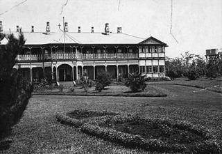
The Darling Downs Institute of Advanced Education (DDIAE) was a tertiary education facility offering undergraduate degrees and certificates in Toowoomba, Queensland Australia, from the 1967 until it was elevated to University College status (1990) and later University status (1992) as the University of Southern Queensland.

University of Southern Queensland university in Australia

The University of Southern Queensland (USQ) is a medium-sized, regional university based in Toowoomba, Queensland, Australia, with three university campuses at Toowoomba, Springfield and Ipswich. It offers courses in law, health, engineering, the sciences, business, education, and the arts. The institution was established in 1967 as the Darling Downs campus of the Queensland Institute of Technology. In 1970, the institution had provided studying programs for rural Queensland and international communities. In 1971, it became the Darling Downs Institute of Advanced Education, then the University College of Southern Queensland in 1990 and finally the University of Southern Queensland in 1992. It operates three research institutes and seven research centres which focus on a wide range of business, agricultural, scientific, environmental, and technological issues.

Australia Country in Oceania

Australia, officially the Commonwealth of Australia, is a sovereign country comprising the mainland of the Australian continent, the island of Tasmania, and numerous smaller islands. It is the largest country in Oceania and the world's sixth-largest country by total area. The neighbouring countries are Papua New Guinea, Indonesia, and East Timor to the north; the Solomon Islands and Vanuatu to the north-east; and New Zealand to the south-east. The population of 25 million is highly urbanised and heavily concentrated on the eastern seaboard. Australia's capital is Canberra, and its largest city is Sydney. The country's other major metropolitan areas are Melbourne, Brisbane, Perth, and Adelaide.

The UCSQ existed between 1990 and 1992.

Coordinates: 27°36′09″S151°55′50.22″E / 27.60250°S 151.9306167°E / -27.60250; 151.9306167

Geographic coordinate system Coordinate system

A geographic coordinate system is a coordinate system that enables every location on Earth to be specified by a set of numbers, letters or symbols. The coordinates are often chosen such that one of the numbers represents a vertical position and two or three of the numbers represent a horizontal position; alternatively, a geographic position may be expressed in a combined three-dimensional Cartesian vector. A common choice of coordinates is latitude, longitude and elevation. To specify a location on a plane requires a map projection.


Related Research Articles

Division of Groom Australian federal electoral division

The Division of Groom is an Australian Electoral Division in Queensland. The division was created in 1984 as essentially a reconfigured version of the old Division of Darling Downs. It is named in honour of Sir Littleton Groom, who represented Darling Downs with only one short break from 1901 to 1936 and served as Speaker of the Australian House of Representatives.

Darling Downs Correctional Centre was an Australian prison facility in Toowoomba, Queensland, Australia.

Shire of Jondaryan Local government area in Queensland, Australia

The Shire of Jondaryan was a local government area located in the Darling Downs region of Queensland, Australia, immediately west of the regional city of Toowoomba. The shire, administered from the town of Oakey, covered an area of 1,910.0 square kilometres (737.5 sq mi), and existed as a local government entity from 1890 until 2008, when it amalgamated with several other councils in the Toowoomba area to form the Toowoomba Region. Its growth in later years has been fuelled by the expansion of Toowoomba and suburbs such as Glenvale and Westbrook.

Electoral District of Drayton and Toowoomba was the original seat for the urban settlement on the eastern Darling Downs, Queensland, Australia.

Shire of Wambo Local government area in Queensland, Australia

The Shire of Wambo was a local government area in the Darling Downs region of Queensland, Australia. The shire completely surrounded but did not include the town of Dalby — which had its own municipal government. It covered an area of 5,709.7 square kilometres (2,204.5 sq mi), and existed as a local government entity from 1879 until 2008, when it amalgamated with the Town of Dalby and the Shires of Chinchilla, Murilla and Tara and the southern part of Taroom to form the Western Downs Region.

Shire of Millmerran Local government area in Queensland, Australia

The Shire of Millmerran was a local government area in the Darling Downs region of Queensland, Australia, about 80 kilometres (50 mi) southwest of the regional city of Toowoomba. The shire covered an area of 4,520.8 square kilometres (1,745.5 sq mi), and existed as a local government entity from 1913 until 2008, when it amalgamated with several other councils in the Toowoomba area to become the Toowoomba Region.

Western Downs Region Local government area in Queensland, Australia

Western Downs Region is a local government area in Queensland, Australia. The Western Downs Regional Council manages an area of 38,039 square kilometres (14,687 sq mi), which is approximately the same size as the country of Switzerland, although with a population at the last census of close to 33,000, it is over 235 times less densely populated.

Darling Downs was an electoral district of the Legislative Assembly in the Australian state of Queensland. It was named for the Darling Downs region.

County of Bentinck Cadastral in Queensland, Australia

The County of Bentinck is a county located on the southern boundary of the state of Queensland, Australia. Like all counties in Queensland, it is a non-functional administrative unit, that is used mainly for the purpose of registering land titles. The county was named in 1838 after William Cavendish-Bentinck, 3rd Duke of Portland, who served as Prime Minister of Great Britain twice, in 1783 and again between 1807 and 1809. Population centres within the County of Bentinck include the towns of Stanthorpe, Wallangarra, Glen Aplin, Applethorpe and Inglewood.

Cabarlah, Queensland Town in Queensland, Australia

Cabarlah is a town and locality in the Toowoomba Region, Queensland, Australia. At the 2016 census, Cabarlah had a population of 1,075.

County of Aubigny Cadastral in Queensland, Australia

The County of Aubigny is a county in Queensland, Australia. Like all counties in Queensland, it is a non-functional administrative unit, that is used mainly for the purpose of registering land titles. The county lies between 151°E and 152°E longitude, and it covers the Toowoomba Region and the Dalby part of the Western Downs Region, The county was named by the Surveyor-General of New South Wales in 1850, possibly to honour the Earl of Arundel who had a long association with the name Aubigny. The area was officially named and bounded by the Governor in Council on 7 March 1901 under the Land Act 1897.

The Shire of Middle Ridge was a local government area in the Darling Downs region of Queensland, Australia, south of Toowoomba, Queensland centred on Middle Ridge. It existed from 1880 to 1917.

Shire of Drayton

The Shire of Drayton was a local government area in the Darling Downs region of Queensland, Australia, west of Toowoomba. It existed between 1887 and 1949.

Shire of Gowrie

The Shire of Gowrie was a local government area in the Darling Downs region of Queensland, Australia.

The Town of Newtown was a local government area in the Darling Downs region of Queensland, Australia, loosely based on the current Newtown, a suburb of Toowoomba. It existed between 1913 and 1917.

Shire of Highfields

The Shire of Highfields is a former local government area on the Darling Downs in Queensland, Australia. It existed between 1879 and 1949.

The Glennie School Anglican girls school in Toowoomba, Queensland, Australia

The Glennie School is a girls' school in Toowoomba, Queensland, Australia. It caters for primary and secondary schooling from K-12. It has boarding house facilities and is owned and operated by the Anglican Church.

4GR is an Australian commercial radio station located in Toowoomba, Queensland, currently broadcasting as Triple M on 864 AM.