Urmston Urban District

Last updated
Urmston Urban District
History
  Created 1894
  Abolished 1974
  Succeeded by Metropolitan Borough of Trafford
Status Urban district

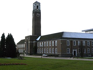
Urmston Urban District was, from 1894 to 1974, a local government district in the administrative county of Lancashire, England which covered the modern-day district of Urmston.

Administrative counties of England Former subnational divisions of England

Administrative counties were a level of subnational division of England used for the purposes of local government from 1889 to 1974. They were created by the Local Government Act 1888 as the areas for which county councils were elected. Some large counties were divided into several administrative counties, each with its own county council. The administrative counties were abolished by the Local Government Act 1972 and were replaced by the metropolitan and non-metropolitan counties of England.

Lancashire County of England

Lancashire is a ceremonial county in North West England. The administrative centre is Preston. The county has a population of 1,449,300 and an area of 1,189 square miles (3,080 km2). People from Lancashire are known as Lancastrians.

England Country in north-west Europe, part of the United Kingdom

England is a country that is part of the United Kingdom. It shares land borders with Wales to the west and Scotland to the north-northwest. The Irish Sea lies west of England and the Celtic Sea lies to the southwest. England is separated from continental Europe by the North Sea to the east and the English Channel to the south. The country covers five-eighths of the island of Great Britain, which lies in the North Atlantic, and includes over 100 smaller islands, such as the Isles of Scilly and the Isle of Wight.

The Urban District was created by the Local Government Act 1894. In 1974 Urmston Urban District was abolished by the Local Government Act 1972 and its former area transferred to the new county of Greater Manchester to form part of the Metropolitan Borough of Trafford.

In England and Wales, Northern Ireland, and the Republic of Ireland, an urban district was a type of local government district that covered an urbanised area. Urban districts had an elected urban district council (UDC), which shared local government responsibilities with a county council.

Local Government Act 1894

The Local Government Act 1894 was an Act of the Parliament of the United Kingdom that reformed local government in England and Wales outside the County of London. The Act followed the reforms carried out at county level under the Local Government Act 1888. The 1894 legislation introduced elected councils at district and parish level.

Local Government Act 1972 Act of Parliament in the United Kingdom

The Local Government Act 1972 is an Act of the Parliament of the United Kingdom that reformed local government in England and Wales on 1 April 1974.

Related Research Articles

Wing Rural District was a rural district in the administrative county of Buckinghamshire, England from 1894 to 1974.

Bredbury and Romiley was an urban district in the administrative county of Cheshire, England from 1894 to 1974, which covered the Civil Parishes of Bredbury, Compstall and Romiley.

Crompton Urban District was, from 1894 to 1974, a local government district in the administrative county of Lancashire, England. The area was coterminate with Shaw and Crompton.

Municipal Borough of Swinton and Pendlebury

Swinton and Pendlebury was a local government district of the administrative county of Lancashire, England. It was created in 1894 as an urban district and enlarged in 1934, gaining the status of a municipal borough.

Bucklow Rural District was, from 1894 to 1974, a local government district in the north of the administrative county of Cheshire, England. Following the Local Government Act 1972, this rural district was split between the new Greater Manchester boroughs of Trafford and Manchester, and Macclesfield, which was retained in Cheshire.

Preston was a rural district in Lancashire, England from 1894 to 1974. It surrounded Preston on the north, west and east sides.

Lees was from 1894 to 1974, a local government district in the administrative county of Lancashire, England.

Chadderton Urban District

Chadderton Urban District was, from 1894 to 1974, a local government district of the administrative county of Lancashire, England. It was centred on the town of Chadderton.

Lathom and Burscough was an urban district in the county of Lancashire from 1894 to 1931. It constituted the civil parishes of Burscough and Lathom, and apart from these two villages also included Newburgh.

Denton Urban District was a local government district in England from 1894 to 1974.

Billinge was, from 1894 to 1974, a local government district in the administrative county of Lancashire, England.

Municipal Borough of Leigh

The Municipal Borough of Leigh was, from 1899 to 1974, a local government district of the administrative county of Lancashire, England, consisting of the townships of Pennington, Westleigh, Bedford and part of the township of Atherton and named after the ancient ecclesiastcal parish. The area contained the market town of Leigh that served as its administrative centre until its dissolution in 1974. The borough council built Leigh Town Hall which was completed in 1907.

Huyton with Roby Urban District was a local government district in Lancashire, England from 1894 to 1974. It consisted of the civil parish of Huyton with Roby which comprised the settlements of Huyton and Roby. It replaced the Huyton with Roby urban sanitary district.

Longendale Urban District

Longendale Urban District was, from 1936 to 1974, a local government district in the administrative county of Cheshire, England. It encompassed parts of Broadbottom, Hattersley, Hollingworth, Matley and Mottram in Longdendale, all of which form part of the non-statutory Longdendale Valley.

Milnrow Urban District

Milnrow Urban District was, from 1894 to 1974, a local government district of the administrative county of Lancashire, in northwest England. It covered an area to the east and southeast of the County Borough of Rochdale, and included the town of Milnrow, the village of New Hey, and the Piethorne Valley; Crompton Urban District lay to the south.

Orrell Urban District was, from 1894 to 1974, a local government district in the administrative county of Lancashire, England. Its boundaries were centred on Orrell, but also included parts of Upholland.

Holywell was a rural district in the administrative county of Flintshire, Wales, from 1894 to 1974.

Barton-upon-Irwell was, from 1894 to 1933, a rural district in the administrative county of Lancashire, England.

Ramsbottom Urban District was, from 1894 to 1974, a local government district of the administrative county of Lancashire, England. Its area was coterminate with Ramsbottom, spanning an area of the Rossendale Valley north of the County Borough of Bury.

Tyldesley Urban District

Tyldesley cum Shakerley Urban District and its successor Tyldesley Urban District was, from 1894 to 1974, a local government district in Lancashire, England.

References

A vision of Urmston UD, visionofbritain.org.uk. URL accessed December 30, 2006.

Coordinates: 53°27′N2°21′W / 53.45°N 2.35°W / 53.45; -2.35

Geographic coordinate system Coordinate system

A geographic coordinate system is a coordinate system that enables every location on Earth to be specified by a set of numbers, letters or symbols. The coordinates are often chosen such that one of the numbers represents a vertical position and two or three of the numbers represent a horizontal position; alternatively, a geographic position may be expressed in a combined three-dimensional Cartesian vector. A common choice of coordinates is latitude, longitude and elevation. To specify a location on a plane requires a map projection.