Walsall Rural District

Last updated

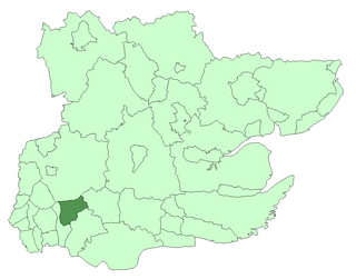
Walsall was a rural district in Staffordshire, England from 1894 to 1934.

Rural districts were a type of local government area – now superseded – established at the end of the 19th century in England, Wales, and Ireland for the administration of predominantly rural areas at a level lower than that of the administrative counties.

Staffordshire County of England

Staffordshire is a landlocked county in the West Midlands of England. It borders with Cheshire to the northwest, Derbyshire and Leicestershire to the east, Warwickshire to the southeast, West Midlands and Worcestershire to the south, and Shropshire to the west.

England Country in north-west Europe, part of the United Kingdom

England is a country that is part of the United Kingdom. It shares land borders with Wales to the west and Scotland to the north-northwest. The Irish Sea lies west of England and the Celtic Sea lies to the southwest. England is separated from continental Europe by the North Sea to the east and the English Channel to the south. The country covers five-eighths of the island of Great Britain, which lies in the North Atlantic, and includes over 100 smaller islands, such as the Isles of Scilly and the Isle of Wight.

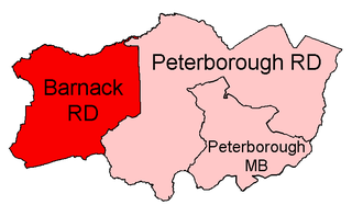
It was created by the Local Government Act 1894 based on Walsall rural sanitary district, and included the five parishes of Aldridge, Bentley, Great Barr, Pelsall and Rushall. Four of these parishes were to the east of Walsall, and Bentley was to the west, forming an exclave.

Local Government Act 1894

The Local Government Act 1894 was an Act of the Parliament of the United Kingdom that reformed local government in England and Wales outside the County of London. The Act followed the reforms carried out at county level under the Local Government Act 1888. The 1894 legislation introduced elected councils at district and parish level.

Walsall town in the English Midlands

Walsall is a large industrialised market town in the West Midlands. Historically part of Staffordshire, it is located 8 miles (13 km) north-west of Birmingham, 6 miles (10 km) east of Wolverhampton and 9 miles (14 km) from Lichfield.

Aldridge town within the Metropolitan Borough of Walsall, in the West Midlands, England

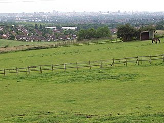
Aldridge is a large village in the West Midlands, England. Historically part of Staffordshire.

It was subject to increased urban development in the early 20th century and was abolished in 1934 under a County Review Order. The parish of Bentley was split between the urban district of Darlaston and the parish of Short Heath (which itself was becoming part of the Willenhall urban district), while the rest of the rural district became the Aldridge urban district, and since 1974 has formed part of the Metropolitan Borough of Walsall in the metropolitan county of West Midlands.

Local Government Act 1929 local government-related UK parliament act of 1929

The Local Government Act 1929 was an Act of the Parliament of the United Kingdom that made changes to the Poor Law and local government in England and Wales.

In England and Wales, Northern Ireland, and the Republic of Ireland, an urban district was a type of local government district that covered an urbanised area. Urban districts had an elected urban district council (UDC), which shared local government responsibilities with a county council.

Darlaston town in the Metropolitan Borough of Walsall in the West Midlands of England

Darlaston is a small market town in the Metropolitan Borough of Walsall in the West Midlands of England. It located near Wednesbury and Willenhall.

Related Research Articles

West Midlands (county) County of England

The West Midlands is a metropolitan county in western-central England with a 2014 estimated population of 2,808,356, making it the second most populous county in England after Greater London. It came into existence as a metropolitan county in 1974 after the passage of the Local Government Act 1972, formed from parts of Staffordshire, Worcestershire and Warwickshire. The county itself is a NUTS 2 region within the wider NUTS 1 region of the same name. The county consists of seven metropolitan boroughs: the City of Birmingham, the City of Coventry and the City of Wolverhampton, as well as the boroughs of Dudley, Sandwell, Solihull and Walsall.

East Suffolk (county)

East Suffolk, along with West Suffolk, was created in 1888 as an administrative county of England. The administrative county was based on the eastern quarter sessions division of Suffolk. East Suffolk County Council's headquarters were at East Suffolk County Hall in Ipswich, which was a county borough in its own right.

Metropolitan Borough of Walsall Metropolitan borough in England

The Metropolitan Borough of Walsall is a local government district in the West Midlands, England, with the status of a metropolitan borough. It is named after its largest settlement, Walsall, but covers a larger area which also includes the towns of Aldridge, Bloxwich, Brownhills, Darlaston and Willenhall. The borough had an estimated population of 254,500 in 2007.

Wednesfield Village and residential area within the city of Wolverhampton, West Midlands, England

Wednesfield is a historic village and residential area within the city of Wolverhampton, West Midlands. It is 2 miles (3.2 km) east-northeast of Wolverhampton city centre, and is part of the West Midlands conurbation. It is historically within the county of Staffordshire.

Aldridge-Brownhills (UK Parliament constituency) Parliamentary constituency in the United Kingdom

Aldridge-Brownhills is a constituency in the West Midlands, represented in the House of Commons of the UK Parliament since 2015 by Wendy Morton of the Conservative Party.

Civil parishes in the West Midlands (county) Wikimedia list article

A civil parish is a subnational entity, forming the lowest unit of local government in England. There are 18 civil parishes in the ceremonial county of West Midlands, most of the county being unparished; Dudley, Sandwell, Walsall and Wolverhampton are completely unparished. At the 2001 census, there were 89,621 people living in the 18 parishes, accounting for 3.5 per cent of the county's population.

Aldridge-Brownhills was an urban district in Staffordshire, England from 1966 to 1974.

Walsall South (UK Parliament constituency) Parliamentary constituency in the United Kingdom

Walsall South is a constituency represented in the House of Commons of the UK Parliament since 2010 by Valerie Vaz, a member of the Labour Party.

Municipal Borough of Romford

Romford was a local government district in southwest Essex from 1851 to 1965. It was significantly expanded in 1934 and gained the status of municipal borough in 1937. The population density of the district consistently increased during its existence and its former area now corresponds to the northern part of the London Borough of Havering in Greater London.

Municipal Borough of Chingford

Chingford was a local government district in south west Essex, England from 1894 to 1965, around the town of Chingford. It was within the London suburbs, forming part of the London postal district and Metropolitan Police District. Its former area now corresponds to the northern part of the London Borough of Waltham Forest in Greater London.

Ashby de la Zouch Rural District was a rural district in England, near Ashby de la Zouch. It was formed in 1894 along with most other rural districts. In 1974 it was abolished under the Local Government Act 1972, to form the non-metropolitan district of North West Leicestershire.

Atherstone was a rural district in the administrative county of Warwickshire, England, from 1894 to 1974. It was named after its main town and administrative headquarters of Atherstone.

Municipal Borough of Swinton and Pendlebury

Swinton and Pendlebury was a local government district of the administrative county of Lancashire, England. It was created in 1894 as an urban district and enlarged in 1934, gaining the status of a municipal borough.

Bentley with Arksey was a civil parish and urban district adjacent to the town of Doncaster in the West Riding of Yorkshire from 1866 to 1974.

Barnack Rural District

Barnack was a rural district in the Soke of Peterborough and later Huntingdon and Peterborough from 1894 to 1974.

Kingswinford Rural District was a rural district in Staffordshire, England from 1894 to 1934. It was created by the Local Government Act 1894, and originally consisted of the two parishes of Amblecote and Kingswinford. Amblecote became a separate urban district in 1898, leaving Kingswinford the only parish in the district.

Bentley is an area in the Metropolitan Borough of Walsall located around Junction 10 of the M6 Motorway. It is also a rural village of houses towards its eastern sides. It shares borders with the areas of Willenhall, Beechdale, Ashmore Park, Pleck, Darlaston and Alumwell.

Pheasey Urban estate in West Midlands, United Kingdom

Pheasey is a residential area of Birmingham Metropolitan Borough in the West Midlands of England, often considered to be part of Great Barr. The area was predominantly developed for housing, as the Pheasey Estate, in the 1930s, but work was not completed until after the Second World War. Barr Beacon, a hill, is a local landmark.

Darlaston Urban District was a local authority which existed within the West Midlands conurbation, England from 1894 until 1966. It was centred on the township of Darlaston in the Black Country, and also incorporated the villages of Bentley and Moxley.

Stratford and Wolverton Rural District (1894–1919), Stratford and Wolverton Urban District (1919–20) and Wolverton Urban District (1920–1974) were local government districts in Buckinghamshire, England, covering the town of Wolverton and its environs.

References

Coordinates: 52°36′N1°55′W / 52.60°N 1.91°W / 52.60; -1.91

Geographic coordinate system Coordinate system

A geographic coordinate system is a coordinate system that enables every location on Earth to be specified by a set of numbers, letters or symbols. The coordinates are often chosen such that one of the numbers represents a vertical position and two or three of the numbers represent a horizontal position; alternatively, a geographic position may be expressed in a combined three-dimensional Cartesian vector. A common choice of coordinates is latitude, longitude and elevation. To specify a location on a plane requires a map projection.