
Kimhwa County is a kun, or county, in Kangwŏn province, North Korea.
The Ali Mohsen al-Muraisi Stadium is a multi-purpose stadium in Sana‘a, Yemen. It is currently used mostly for football matches and serves as the home stadium of Al-Ahli. The stadium holds 25,000 people.
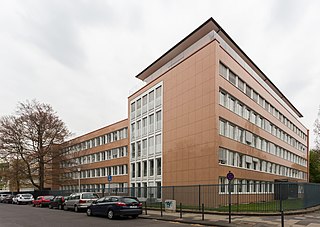
The Federal Cartel Office (Germany) is Germany's national competition regulator. It was first established in 1958 and comes under the authority of the Federal Ministry for Economic Affairs and Energy. Its headquarters are in the former West German capital, Bonn and its President is Andreas Mundt, who has a staff of 300 people. Today it administers competition law in Germany.

Vicat SA is a French company manufacturing cement, aggregates and ready-mix concrete in four continents.
Krivandino is a village in Velikoluksky District of Pskov Oblast, Russia.

Hanna is an unincorporated census-designated place in Hanna Township, LaPorte County, Indiana. It had a population of 463 at the 2010 census.
Stade Messaoud Zeghar is a multi-use stadium in El Eulma, Algeria. It is currently used mostly for football matches and is the home ground of MC El Eulma of the Algerian Championnat National. The stadium holds 25,000 spectators.
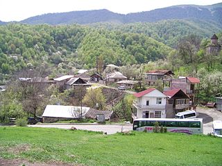
Gosh is a village located in the Tavush Province of Armenia. It is named after Mkhitar Gosh who took part in the re-building of the older monastery of Nor Ghetik during the 12th-13th centuries, which had been destroyed by an earthquake in 1188. The newly built monastery was later named Goshavank in honor of Mkhitar. Goshavank is located just off the main highway that runs through town. On a hillside west of the monastery complex sits a chapel that also serves as the tomb of Mkhitar Gosh. It was situated to overlook the monastery in which he helped build. The chapel is square in plan with a single centrally located dome above and one portal. Nearby are the ruins of what are said to be Mkhitar's house. Stone foundations and low walls still exist.

Pokr Masrik is a town in the Gegharkunik Province of Armenia. The town has a 12th-century church. Mets Masrik is nearby.

Szostaki is a village in the administrative district of Gmina Łukowa, within Biłgoraj County, Lublin Voivodeship, in eastern Poland. It lies approximately 4 kilometres (2 mi) north of Łukowa, 20 km (12 mi) south-east of Biłgoraj, and 96 km (60 mi) south of the regional capital Lublin.
Dąbrówka-Malice is a village in the administrative district of Gmina Zgierz, within Zgierz County, Łódź Voivodeship, in central Poland.
Czarnoszki is a village in the administrative district of Gmina Człuchów, within Człuchów County, Pomeranian Voivodeship, in northern Poland. It lies approximately 10 kilometres (6 mi) north-east of Człuchów and 106 km (66 mi) south-west of the regional capital Gdańsk.
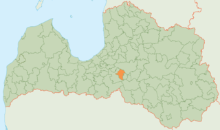
Lielvārde Municipality is a municipality in Vidzeme, Latvia. The municipality was formed in 2004 by reorganization of Lielvārde town with its countryside territory. In 2009 it absorbed Jumprava parish and Lēdmane parish, the administrative centre being Lielvārde. In 2010 Lielvārde parish was created from the countryside territory of Lielvārde town.

Parkhill is an unincorporated community in Butte County, California. It lies at an elevation of 1942 feet. Parkhill is located at 39°43′21″N121°29′48″W.

The Cow Yard Brook is a small tributary of the Oakeys Brook, in central South Brunswick, New Jersey in the United States.
Rauberflaket is a mountain of Buskerud, in southern Norway.
Suur-Randvere is a village in Saaremaa Parish, Saare County in western Estonia.
Ramnavallen is a football stadium in Borås, Sweden and the former home stadium for the football teams IF Elfsborg and Norrby IF. Ramnavallen has a total capacity of 4,000 spectators.

Ayun is an administrative unit, known as Union Council and village in Chitral district, Khyber Pakhtunkhwa, Pakistan, 12 km south of the town of Chitral. It is located on the Chitral River at its confluence with the Bumburet River. Mountains surround the village. The Bumburet River runs the length of the village and is harnessed to generate electricity for both Ayun and for the village of Broze. The Bumburet River also provides water for irrigation and for drinking.
Puerta del Ángel is a neighborhood (barrio) of Madrid belonging to the district of Latina.


