The Rupununi savannah is a savanna plain in Guyana, in the Upper Takutu-Upper Essequibo region. It is part of the Guianan savanna ecoregion of the tropical and subtropical grasslands, savannas, and shrublands biome.

The Macushi are an indigenous people living in the borderlands of southern Guyana, northern Brazil in the state of Roraima, and in an eastern part of Venezuela.
Achiwib is a village in the Upper Takutu-Upper Essequibo Region of Guyana. Achiwib is an Amerindian community that borders Brazil, the main language spoken in the village is Wapishana language.
Apoteri is a village in the Upper Takutu-Upper Essequibo Region of Guyana, near the confluence of the Rupununi River with the Essequibo, at an altitude of 53 metres. Apoteri started to develop as the centre of the balatá industry. The population is mainly Amerindian of the Macushi and Wapishana people.
Dadanawa Ranch is located on the Rupununi River in the Rupununi savannah in the Upper Takutu-Upper Essequibo Region of Guyana. It is the largest and one of the most isolated cattle ranches in Guyana.
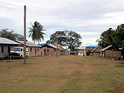
Aishalton is an Amerindian village that is situated in the Rupununi savannah of southern Guyana, in the Upper Takutu-Upper Essequibo Region of the country.
Wowetta is an indigenous village in the Upper Takutu-Upper Essequibo Region in Guyana. The village is mainly inhabited by Macushi people.
Surama is an Amerindian village in the North Rupununi area and the Upper Takutu-Upper Essequibo Region of Guyana, with a population of 274 people as of 2012.
Fairview (Kurupukari) is an indigenous settlement on the Essequibo River, in the Upper Demerara-Berbice region of Guyana. It is the entry point to the Iwokrama Forest. Former president David A. Granger once referred to Iwokrama as the "green heart of Guyana."
Aranaputa is an Amerindian village in the Upper Takutu-Upper Essequibo, Guyana. It is located in the Pacaraima Mountains.
Rewa is an Amerindian village in the Upper Takutu-Upper Essequibo region of Guyana.
Hiawa is an indigenous village of Macushi Amerindians in the Upper Takutu-Upper Essequibo Region of Guyana. It is located in the Rupununi savannah. Hiawa is considered a satellite of Nappi.
St. Ignatius is an Amerindian village in the Upper Takutu-Upper Essequibo region of Guyana, near the regional capital Lethem and the border of Brazil. It was originally a mission founded by Jesuit priests to serve the Amerindians in the Rupununi savannah.
Karaudarnau is an indigenous village of Wapishana Amerindians in the Upper Takutu-Upper Essequibo Region of Guyana. It is located in the Rupununi savannah on the Rupununi River.
Sand Creek is a village in the Upper Takutu-Upper Essequibo Region of Guyana. Sand Creek is inhabited by Wapishana Amerindians. It is located on the Rupununi River. The main language spoken in the village is Wapishana with English as secondary language.
Katoonarib is a village in the Upper Takutu-Upper Essequibo Region of Guyana. Katoonarib is inhabited by Wapishana, Macushi and other Amerindians. It is located near the Rupununi River. The main language spoken in the village is Wapishana with English as secondary language.
Toka is an indigenous village of Macushi Amerindians in the Upper Takutu-Upper Essequibo Region of Guyana. It is located in the North Rupununi Wetlands.
Nappi is an indigenous village of Macushi Amerindians in the Upper Takutu-Upper Essequibo Region of Guyana. It is located in the Rupununi savannah along the Nappi and Maipaima creeks on the edge of the Kanuku Mountains.
Sawariwau is a village in the Upper Takutu-Upper Essequibo Region of Guyana. Sawariwau is inhabited by Wapishana Amerindians. It is located about 70 miles (110 km) south of Lethem in the Rupununi savannah. The main language spoken in the village is Wapishana.
Maruranau is an indigenous village of Wapishana Amerindians in the Upper Takutu-Upper Essequibo Region of Guyana. It is located in the Rupununi savannah near the Kwitaro River on the edge of the Kanuku Mountains. A minority of Taruma also inhabit the village.