Arsenal tube station

Last updated

Arsenal Underground no-text.svg
Arsenal station entrance.JPG
Station entrance
Greater London UK location map 2.svg
Red pog.svg
Arsenal
Location of Arsenal in Greater London
Location Highbury
Local authority London Borough of Islington
Managed by London Underground
Number of platforms2
Fare zone 2
London Underground annual entry and exit
2018Increase2.svg 3.24 million [1]
2019Decrease2.svg 2.77 million [2]
2020Decrease2.svg 1.00 million [3]
2021Increase2.svg 1.21 million [4]
2022Increase2.svg 2.12 million [5]
Railway companies
Original company Great Northern, Piccadilly and Brompton Railway
Key dates
15 December 1906Opened as Gillespie Road
31 October 1932Renamed Arsenal (Highbury Hill)
c. 1960Renamed Arsenal
Other information
External links
Coordinates 51°33′31″N0°06′21″W / 51.55861°N 0.10583°W / 51.55861; -0.10583
Underground sign at Westminster.jpg London transportportal

Arsenal is a London Underground station located in Highbury, London. It is on the Piccadilly line, between Holloway Road and Finsbury Park stations, in Travelcard Zone 2. [6] Originally known as Gillespie Road, it was renamed in 1932 after Arsenal Football Club, who at the time played at the nearby Highbury Stadium. It is the only tube station named directly after a football club. [lower-alpha 1] Although Highbury Stadium closed in 2006, the station retains its name and is still used by spectators attending matches at Arsenal's nearby Emirates Stadium.

Contents

Location

The station is located on a narrow Victorian residential street, away from any main roads. [7] It is also unusual in not having any bus routes pass its entrance, though routes 4, 19, 106 and 236 serve nearby Blackstock Road. [8]

History

Tiling on the platform indicates the station's previous guise as "Gillespie Road". Arsenal tube station interior.jpg
Tiling on the platform indicates the station's previous guise as "Gillespie Road".

Arsenal tube station was opened by the Great Northern, Piccadilly and Brompton Railway (GNP&BR) as Gillespie Road on 15 December 1906. [9] [10] The GNP&BR was later renamed the Piccadilly line after the consolidation and nationalisation of the Tube network as London Underground. The original station building and ticket hall were red terracotta-clad buildings designed by Leslie Green, similar to neighbouring stations such as Holloway Road and Caledonian Road.

At the time of Gillespie Road's construction, it served a residential area and a local divinity college.[ citation needed ] In 1913, Arsenal F.C. moved from Woolwich to Highbury on the site of the college's playing fields, and the club's presence there eventually led to a campaign for a change of name. Arsenal manager Herbert Chapman was a particularly keen advocate, and on 31 October 1932 it was renamed Arsenal (Highbury Hill). [11] The station was expanded in the 1930s, when the original station building was demolished and replaced by a wider building of a more modern design.

The suffix was dropped from the station's name some time around 1960, giving the current name of Arsenal. [lower-alpha 2] The original tiled walls of the platforms still bear the Gillespie Road name, spelt out in large letters. [16] In 2007, the station underwent a major upgrade; [17] as part of this the wall tiling was completely restored, the floor resurfaced and an electronic Tannoy system was introduced. [18]

Station layout

Passageway linking the ticket office to the platforms, looking towards the latter. Note tidal flow segregation, in operation on football match days. The fans would use the wider section. Tidal segregation at Arsenal, 2021.jpg
Passageway linking the ticket office to the platforms, looking towards the latter. Note tidal flow segregation, in operation on football match days. The fans would use the wider section.

When it was first built, the station building was squeezed between residential properties on each side, occupying the width of just two terraced houses. Even after the surface building was rebuilt and widened in the early 1930s, with a further house being demolished, it has one of the narrowest frontages of any Underground station.

Unusually for a "deep level" tube station, Arsenal possesses neither escalators nor lifts. Instead, a sloping passageway leads down to the platforms. This is due to the tunnels being both relatively shallow at this point and situated some distance from the station entrance (being underneath the East Coast Main Line). There are short flights of stairs at both ends of the passageway, so the station is not wheelchair accessible. When the station was rebuilt in the early 1930s, an extra tunnel was dug to platform level from the main access passage in anticipation of increased traffic. This is now used to handle the large crowds on match days. The station has a "tidal" system unique on the Underground network, with a narrow section on one side divided from the main passageway by a full-height fence. The narrow section is used on match days for the lighter flow, according to time of day—for passengers catching trains before matches, or leaving the station afterwards.

Usage

Map of Arsenal's old and new stadiums in relation to Arsenal tube station Ashburton Grove.svg
Map of Arsenal's old and new stadiums in relation to Arsenal tube station

The station is considerably less busy than other stations on the same stretch of line. In 2007 only 2,735,000 entries and exits were recorded, compared with Holloway Road's 7,487,000 and Caledonian Road's 5,333,000. [19]

In 2006 Arsenal F.C. moved to a new stadium, the Emirates Stadium. The stadium is on the site of Ashburton Grove, a former industrial estate approximately 500 metres (1,600 ft) west of Highbury, and marginally closer to Drayton Park (on the Northern City Line) and Holloway Road stations. [lower-alpha 3] However, Drayton Park is closed on match days due to its small platform size and infrequent service (before 2015 it had no weekend service at all), and trains do not stop at Holloway Road before and after matches to prevent overcrowding. Arsenal station meanwhile is still within easy walking distance of the new stadium's main entrance and is recommended by the club for use on match days. [20] The station thus still retains the "Arsenal" name and, along with Finsbury Park and Highbury & Islington, is still used by many Arsenal supporters to get to matches.

As part of the commemoration of Arsenal F.C.'s move, a temporary mural was placed along the walls of the station passageways as part of London Underground's Art on the Underground scheme. [21] It was unveiled in February 2006 and removed in September.

Services and connections

Piccadilly line train at Arsenal Arsenal Underground Station.jpg
Piccadilly line train at Arsenal

Train frequencies vary throughout the day, but generally operate every 2–6 minutes between 06:22 and 00:19 in both directions. [22] [23]

No bus routes directly serve the station. However, London Bus routes 4, 19, 29, 91, 106, 153, 236, 253, 254 and 259 and night routes N19, N29, N91, N253 and N279 are all nearby. [24] [25]

Notes

  1. Several tube stations, including West Ham and Wimbledon, share their names with football clubs, but only Arsenal was named directly after a club rather than the associated area.
  2. An early 1960 edition [12] of the Tube map shows the "Highbury Hill" suffix but one from later in 1960 [13] shows it without. No subsequent maps include the suffix. [14] [15]
  3. This is as measured from the pitch itself; measured from the main entrance to the stadium complex in the northeast corner, Arsenal remains the closest station.

Related Research Articles

<span class="mw-page-title-main">Waterloo tube station</span> London Underground station

Waterloo is a London Underground station located beneath Waterloo National Rail station. As of 2022, it is the 2nd busiest station on the London Underground, with 68.72 million users. It is served by four lines: Bakerloo, Jubilee, Northern and Waterloo & City.

<span class="mw-page-title-main">Bounds Green tube station</span> London Underground station

Bounds Green is a London Underground station, located at the junction of Bounds Green Road and Brownlow Road in Bounds Green in the London Borough of Haringey, North London. The station is on the Piccadilly line, between Wood Green and Arnos Grove stations, and is on the boundary between Zone 3 and Zone 4.

<span class="mw-page-title-main">Finsbury Park station</span> London Underground and railway station

Finsbury Park is an intermodal interchange station in North London for London Underground, National Rail and London Buses services. The station is the third busiest Underground station outside Zone 1, with over 33 million passengers using the station in 2019.

<span class="mw-page-title-main">King's Cross St Pancras tube station</span> London Underground station

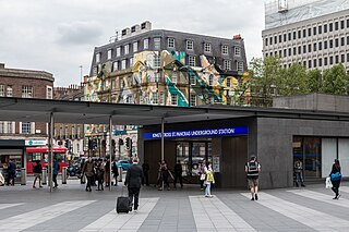
King's Cross St Pancras is a London Underground station on Euston Road in the Borough of Camden, Central London. It serves King's Cross and St Pancras main line stations in fare zone 1, and is an interchange between six Underground lines. The station was one of the first to open on the network. As of 2022, it is the most used station on the network for passenger entrances and exits combined.

<span class="mw-page-title-main">Highbury & Islington station</span> London Underground and railway station

Highbury & Islington is an interchange station in the London Borough of Islington, North London for London Underground, London Overground and National Rail services

<span class="mw-page-title-main">Green Park tube station</span> London Underground station

Green Park is a London Underground station located on the edge of Green Park, with entrances on both sides of Piccadilly. The station is served by three lines: Jubilee, Piccadilly and Victoria. On the Jubilee line, it is between Bond Street and Westminster stations; on the Piccadilly line, it is between Hyde Park Corner and Piccadilly Circus stations and on the Victoria line, it is between Victoria and Oxford Circus stations. It is in fare zone 1.

<span class="mw-page-title-main">St Paul's tube station</span> London Underground station

St Paul's is a London Underground station located in the City of London financial district. The station, which takes its name from the nearby St Paul's Cathedral, is on the Central line, between Bank and Chancery Lane stations, and is in fare zone 1.

<span class="mw-page-title-main">Covent Garden tube station</span> London Underground station

Covent Garden is a London Underground station serving Covent Garden and the surrounding area in the West End of London. It is on the Piccadilly line between Leicester Square and Holborn stations and is in Travelcard Zone 1. The station is at the corner of Long Acre and James Street and the street-level concourse is a Grade II listed building.

<span class="mw-page-title-main">Gloucester Road tube station</span> London Underground station

Gloucester Road is a London Underground station in Kensington, west London. The station entrance is located close to the junction of Gloucester Road and Cromwell Road. Close by are the Cromwell Hospital and Baden-Powell House.

<span class="mw-page-title-main">Russell Square tube station</span> London Underground station

Russell Square is a London Underground station opposite Russell Square on Bernard Street, Bloomsbury, in the London Borough of Camden. The station is on the Piccadilly line, between Holborn and King's Cross St Pancras and is in Travelcard Zone 1.

<span class="mw-page-title-main">Archway tube station</span> London Underground station

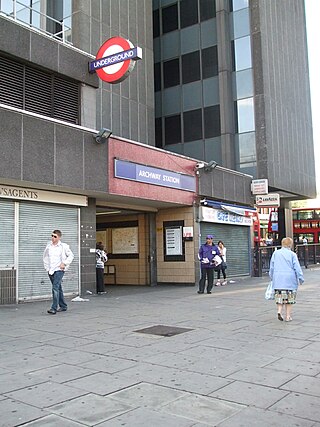
Archway is a London Underground station at the intersection of Holloway Road, Highgate Hill, Junction Road and Archway Road in Archway, north London, directly underneath the Vantage Point building. It is on the High Barnet branch of the Northern line, between Highgate and Tufnell Park stations, in Zones 2 and 3.

<span class="mw-page-title-main">Drayton Park railway station</span> National Rail station in London, England

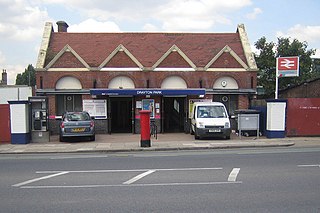
Drayton Park is a National Rail station in Highbury, in the London Borough of Islington. It is on the Northern City Line between Highbury & Islington and Finsbury Park stations, 2 miles 56 chains (4.3 km) down the line from Moorgate; it is in Travelcard Zone 2.

<span class="mw-page-title-main">Arnos Grove tube station</span> London Underground station

Arnos Grove is a London Underground station located in Arnos Grove in the London Borough of Enfield, London. It is on the Piccadilly line between Bounds Green and Southgate stations and is in Travelcard Zone 4. The station opened on 19 September 1932 as the most northerly station on the first section of the Piccadilly line extension from Finsbury Park to Cockfosters. It was the terminus of the line until services were further extended to Oakwood on 13 March 1933. When travelling from east of Barons Court and through Central London, Arnos Grove is the first surface station after the long tunnel section of the Piccadilly line. The station has four platforms which face three tracks.

<span class="mw-page-title-main">Wood Green tube station</span> London Underground station

Wood Green is a London Underground station. It is on the Piccadilly line between Turnpike Lane and Bounds Green stations and is in Travelcard Zone 3. It is located at the junction of High Road, Wood Green and Lordship Lane. It serves Wood Green Shopping City and the nearby Haringey Council administrative complex as well as a densely populated residential area. It is also the closest tube station to Alexandra Palace.

<span class="mw-page-title-main">Manor House tube station</span> London Underground station

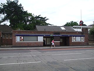
Manor House is a London Underground station. It is on the Piccadilly line between Finsbury Park and Turnpike Lane stations, and is on the boundary between Travelcard Zone 2 and Zone 3. It straddles the border between the London Boroughs of Hackney and Haringey, the postal address and three of the entrances being in the former, and one entrance in the latter.

<span class="mw-page-title-main">Holloway Road tube station</span> London Underground station

Holloway Road is a station on the London Underground. It is on the Piccadilly line between Caledonian Road and Arsenal stations, and in Travelcard Zone 2. The station opened on 15 December 1906.

<span class="mw-page-title-main">Mill Hill East tube station</span> London Underground station

Mill Hill East is a London Underground station in Mill Hill in the London Borough of Barnet, north London. The station is the terminus and only station of a single-track branch of the Northern line from Finchley Central station and is in Travelcard Zone 4. It is the least used station on the Northern line with 1.41 million passengers in 2022.

<span class="mw-page-title-main">South Ealing tube station</span> London Underground station

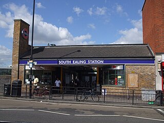
South Ealing tube station is a London Underground station in the London Borough of Ealing. The station is on the Heathrow Airport branch of the Piccadilly line, between Acton Town and Northfields stations. It is located on South Ealing Road and is in Travelcard Zone 3.

<span class="mw-page-title-main">Caledonian Road tube station</span> London Underground station

Caledonian Road is a station on the Piccadilly line of the London Underground, between King's Cross St. Pancras and Holloway Road, and in Travelcard Zone 2. It was opened on 15 December 1906 by the Great Northern, Piccadilly and Brompton Railway. The building was designed by Leslie Green.

<span class="mw-page-title-main">Stamford Brook tube station</span> London Underground station

Stamford Brook is a London Underground station on the eastern edge of Chiswick in west London. The station is served by the District line and is between Ravenscourt Park and Turnham Green stations. The main entrance is located on Goldhawk Road (A402) with a secondary entrance on Prebend Gardens. It is in Travelcard Zone 2.

References

  1. "Station Usage Data" (CSV). Usage Statistics for London Stations, 2018. Transport for London. 23 September 2020. Archived from the original on 14 January 2023. Retrieved 11 October 2023.
  2. "Station Usage Data" (XLSX). Usage Statistics for London Stations, 2019. Transport for London. 23 September 2020. Archived from the original on 9 November 2020. Retrieved 9 November 2020.
  3. "Station Usage Data" (XLSX). Usage Statistics for London Stations, 2020. Transport for London. 16 April 2021. Retrieved 1 January 2022.
  4. "Station Usage Data" (XLSX). Usage Statistics for London Stations, 2021. Transport for London. 12 July 2022. Retrieved 7 September 2022.
  5. "Station Usage Data" (XLSX). Usage Statistics for London Stations, 2022. Transport for London. 4 October 2023. Retrieved 10 October 2023.
  6. Standard Tube Map (PDF) (Map). Not to scale. Transport for London. November 2022. Archived (PDF) from the original on 7 November 2022. Retrieved 12 November 2022.
  7. Google Maps – Arsenal Tube Station
  8. "Buses from Arsenal / Emirates Stadium" (PDF). Transport for London. Archived (PDF) from the original on 27 September 2007.
  9. "London Underground history 1900-1909". Archived from the original on 21 March 2012.
  10. Feather, Clive. "Piccadilly line". Clive's Underground Line Guides. Archived from the original on 3 April 2015. Retrieved 8 April 2015.
  11. "Arsenal Underground Station Renamed Earlier Than Believed". TheArsenalHistory.com. 31 October 2015.
  12. "Early 1960 tube map". Archived from the original on 4 December 2002.
  13. "Late 1960 tube map" (JPG). Archived from the original on 6 November 2004.
  14. "The London Tube Map Archive". Archived from the original on 11 August 2007.
  15. "A History of the London Tube Maps". Archived from the original on 15 August 2007.
  16. "Tube Stations with other/alternative names". Tube Facts and Figures. Geofftech. Archived from the original on 3 April 2015. Retrieved 3 April 2015.
  17. "Station Refurbishment Summary" (PDF). London Underground Railway Society. July 2007. Archived from the original (PDF) on 8 November 2014. Retrieved 8 April 2015.
  18. "Modernisation of Arsenal station continues". Transport for London. 21 February 2007. Archived from the original on 25 April 2012.
  19. "London Underground: Entries and exits". Transport for London. Archived from the original on 25 September 2012.
  20. "Get to... Emirates Stadium". Arsenal.com. Archived from the original on 8 April 2015.
  21. "Platform for Art: Arsenal Football Club's last season at Highbury". Transport for London. Archived from the original on 30 September 2007.
  22. "Piccadilly line timetable: From Arsenal Underground Station to Finsbury Park Underground Station". Transport for London . Retrieved 8 April 2015.
  23. "Piccadilly line timetable: From Arsenal Underground Station to Holloway Road Underground Station". Transport for London . Retrieved 8 April 2015.
  24. "Buses from Arsenal (Emirates Stadium)" (PDF). Transport for London. July 2014. Retrieved 8 April 2015.
  25. "Night buses from Arsenal (Emirates Stadium)" (PDF). Transport for London. July 2014. Retrieved 8 April 2015.

Further reading

Preceding station Underground no-text.svg London Underground Following station
Holloway Road Piccadilly line Finsbury Park