The Trent–Severn Waterway is a 386-kilometre-long (240 mi) canal route connecting Lake Ontario at Trenton to Georgian Bay, Lake Huron, at Port Severn. Its major natural waterways include the Trent River, Otonabee River, Kawartha Lakes, Lake Simcoe, Lake Couchiching and Severn River. Its scenic, meandering route has been called "one of the finest interconnected systems of navigation in the world".

Lake Simcoe is a lake in southern Ontario, Canada, the fourth-largest lake wholly in the province, after Lake Nipigon, Lac Seul, and Lake Nipissing. At the time of the first European contact in the 17th century the lake was called Ouentironk by the native Wendat/Ouendat (Huron) people. It was also known as Lake Taronto until it was renamed by John Graves Simcoe, the first Lieutenant-Governor of Upper Canada, in memory of his father, Captain John Simcoe of the Royal Navy. In Anishinaabemowin, the ancestral language of the First Nations living around this lake, namely Anishinaabek of Rama and Georgina Island First Nations, Lake Simcoe is called Zhooniyaang-zaaga'igan, meaning "Silver Lake".

Brock is a township in the Regional Municipality of Durham, Ontario, Canada. Brock Township is also a former municipality and geographic township prior to the amalgamation that formed the current municipality.

The City of Kawartha Lakes is a unitary municipality in Central Ontario, Canada. It is a municipality legally structured as a single-tier city; however, Kawartha Lakes is the size of a typical Ontario county and is mostly rural. It is the second largest single-tier municipality in Ontario by land area.
Port Perry is a community located in Scugog, Ontario, Canada. The town is located 84 kilometres (52 mi) northeast of central Toronto and north of Oshawa and Whitby. Port Perry has a population of 9,453 as of 2016.

Thorah Island is a lake island located in the southeast portion of Lake Simcoe, approximately 4 kilometres (2.5 mi) west from Beaverton in Ontario, Canada. The island, part of Brock Township, is approximately 1,450 acres (6 km²) in size and the land is divided mainly between wooded and wooded-swamp terrain. Some land has been cleared for farming and recreational purposes but much of the agricultural land has fallen into disuse and has grown over. Centre Road runs from the east side of the island to the west side but is not much more than a dirt path. A small harbour exists on the east side of the island, directly across from Beaverton Harbour. There are several sandy beaches on the west side of the island, but most of the island's shore is rocky.

Ramara is a lower-tier township municipality in Simcoe County, Ontario, Canada.

Severn is a township in south-central Ontario, Canada, located between Lake Couchiching, and the Severn River in Simcoe County.
The Talbot River is a river in the Great Lakes Basin in Central Ontario, Canada which flows from Talbot Lake to Lake Simcoe and forms the border between Ramara township to the north and the Brock township to the south from the river mouth to the edge of their border with the city of Kawartha Lakes at the east.
The Municipality of Trent Lakes is a lower-tier township in the rural, mostly wooded northern section of Peterborough County, Ontario, Canada. The municipality has a primarily cottage and tourist industry based economy but has grown year round residency due to its commute distance to the Greater Toronto Area.
Ontario County was the name of two historic counties in the Canadian province of Ontario.

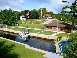
Bobcaygeon is a community on the Trent–Severn Waterway in the City of Kawartha Lakes, east-central Ontario, Canada.
King's Highway 48, also known as Highway 48, is a provincially maintained highway in southern Ontario that extends from Major Mackenzie Drive in Markham, through Whitchurch-Stouffville and East Gwillimbury, to Highway 12 south-east of Beaverton. The route is generally rural and straight, passing near several communities within the Regional Municipality of York. The route is 65.2 kilometres (40.5 mi) long. Most part of the road has a speed limit of 80 km/h (50 mph), except within town limits, where the speed limit is reduced to 60 km/h (37 mph) or 50 km/h (31 mph).

Sutton is a suburban community located nearly 2 km south of Lake Simcoe in Ontario, Canada. The community was formerly a village but is now part of the Town of Georgina after amalgamation with it and North Gwillimbury in 1971. The Black River runs on the north end of the downtown. Highway 48 goes just south of the downtown. Sutton has a population of just over 6,000 people. Sutton is located about 1 hour north of Toronto.
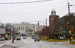
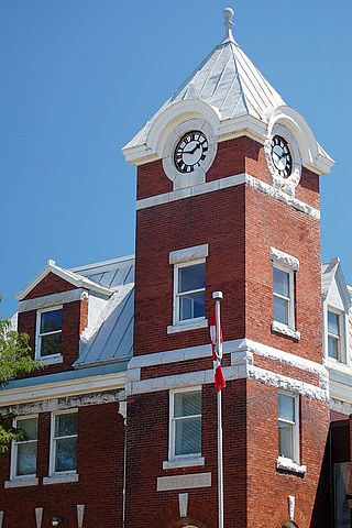
Cannington is a community in Brock Township, Durham Region, Ontario, Canada. The town is on the Beaver River.
The Midland Railway of Canada was a historical Canadian railway which ran from Port Hope, Ontario to Midland on Georgian Bay. The line was originally intended to run to Peterborough, but the competing Cobourg and Peterborough Railway was completed in 1854 and the owner's plans changed. Redirecting the line northward, it opened as the Port Hope, Lindsay & Beaverton Railway, a much longer line than originally planned. A further expansion launched in 1869 pushed the line westward towards Georgian Bay, and prompted renaming as the Midland Railway.
King's Highway 12, commonly referred to as Highway 12 and historically known as the Whitby and Sturgeon Bay Road, is a provincially maintained highway in the Canadian province of Ontario. The highway connects the eastern end of the Greater Toronto Area (GTA) with Kawartha Lakes, Orillia and Midland before ending at Highway 93. It forms the Central Ontario Route of the Trans-Canada Highway system from north of Sunderland to Coldwater. Highway 12 connects several small towns along its 146 km (91 mi) route, and bypasses a short distance from many others. It is signed as a north–south route between Whitby and Orillia, and as an east–west route from there to Midland. The rural portions of the highway feature a posted speed limit of 80 km/h (50 mph), often dropping to 50 km/h (31 mph) through built-up areas. The entire route is patrolled by the Ontario Provincial Police.
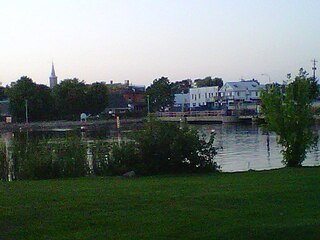
Hastings is a community within the municipality of Trent Hills, Northumberland County, in the province of Ontario, Canada. It is situated on the Trent-Severn Waterway and the Trans Canada Trail in what is considered to be Ontario's "cottage country". It can be reached from Highway 401 by exiting at exit 474 at Cobourg and going north on County Road 45. It can be reached from Highway 7 at the Norwood exit going south.
Thorah Township is a former municipality that today is a geographic township in the municipality of Brock, Regional Municipality of Durham in Central Ontario, Canada.

Canal Lake is a lake of Ontario, Canada, situated in the City of Kawartha Lakes. The lake is triangular, roughly 8.4 kilometres (5.2 mi) long and 2.6 kilometres (1.6 mi) at its widest point, with an area of 2,136 acres (864 ha). The depth ranges from 4.44 feet (1.35 m) to a max depth of 15 feet (4.6 m). Canal Lake is a medium size lake with a large diversity of fishing spots.