
Launceston is a city in the north of Tasmania, Australia, at the confluence of the North Esk and South Esk rivers where they become the Tamar River (kanamaluka). Launceston has a population of 87,645 (2021). Launceston is the second most populous city in Tasmania after the state capital, Hobart, As of 2020, Launceston is the 18th largest city in Australia. Launceston is fourth-largest inland city and the ninth-largest non-capital city in Australia. Launceston is the most liveable regional city, and was one of the most popular regional cities to move to in Australia from 2020 to 2021. Launceston won the Australian town of the year in 2022.
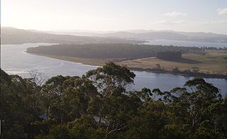
The Tamar River, officially kanamaluka / River Tamar, is a 70-kilometre (43-mile) estuary located in northern Tasmania, Australia. Despite being called a river, the waterway is a brackish and tidal estuary over its entire length.

Strahan, is a small town and former port on the west coast of Tasmania. It is now a significant locality for tourism in the region.

George Town is a large town in north-east Tasmania, on the eastern bank of the mouth of the Tamar River. The Australian Bureau of Statistics records the George Town Municipal Area had a population of 6,764 as of 30 June 2016.

Beaconsfield is a former gold mining town near the Tamar River, in the north-east of Tasmania, Australia. It lies 40 kilometres north of Launceston on the West Tamar Highway. It is a rural and residential locality in the local government areas (LGA) of West Tamar and Latrobe in the Launceston and North-west and west LGA regions of Tasmania. The 2016 census has a population of 1298 for the state suburb of Beaconsfield.

Beauty Point is a town by the Tamar River, in the north-east of Tasmania, Australia. It lies 45 km north of Launceston, on the West Tamar Highway and at the 2016 census, had a population of 1,222. It is part of the Municipality of West Tamar Council.
Rio Tinto Aluminium is now known as Rio Tinto Alcan after Rio's takeover of Alcan. It was the world's eighth largest aluminium company. It mines and manufactures bauxite, alumina and primary aluminium.
The mines of the West Coast of Tasmania have a rich historical heritage as well as an important mineralogical value in containing or having had found, specimens of rare and unusual minerals. Also, the various mining fields have important roles in the understanding of the mineralization of the Mount Read Volcanics, and the occurrence of economic minerals.

The North Esk River is a major perennial river located in the northern region of Tasmania, Australia.

The Tamar Conservation Area covers approximately 4,633 ha on the Tamar River estuary in Tasmania. It includes the Tamar Island Wetlands Reserve and a stretches through the upper part of the Tamar Estuary from St Leonards to the Batman Bridge. It is a popular area for birdwatching and is about 15 minutes drive from Launceston. There are approximately 3.2 km of walking tracks at the wetlands including a boardwalk for easy access to the island.

Rail transport in Tasmania consists of a network of narrow gauge track of 1,067 mm reaching virtually all cities and major towns in the island state of Tasmania, Australia. Today, rail services are focused primarily on bulk freight, with no commercial passenger services being operated. The mainline railways of Tasmania are currently operated by TasRail, a Government of Tasmania-owned Corporation, who owns and maintains both rolling stock, locomotives, and track infrastructure.

Launceston City Council is a local government body in Tasmania, located in the city and surrounds of Launceston in the north of the state. The Launceston local government area is classified as urban and has a population of 67,449, which also encompasses the localities including Lilydale, Targa and through to Swan Bay on the eastern side of the Tamar River.
The Bell Bay aluminium smelter is located on the Tamar River at Bell Bay, Tasmania, Australia. The smelter has a production capacity of 178,000 tonnes of aluminium per year. It is owned and operated by Pacific Aluminium, a wholly owned subsidiary of Rio Tinto Alcan.
York Town is a rural locality in the local government areas (LGA) of West Tamar and Latrobe in the Launceston and North-west and west LGA regions of Tasmania. The locality is about 7 kilometres (4.3 mi) north-west of the town of Beaconsfield. The 2016 census has a population of 72 for the state suburb of York Town. It was the first attempt to establish a British presence in northern Tasmania, in 1804. It was a "bustling village" until 1808.

Bass Strait Ferries have been the ships that have been used for regular transport across Bass Strait between Tasmania and Victoria in mainland Australia, as well as the various attempts to link Tasmania with Sydney. Historically, some regular shipping services in the twentieth century linked Sydney, Melbourne and Hobart with the Bass Strait ports: Launceston's various port locations, Devonport and Burnie. The distinction between coastal shipping and Bass Strait ferry has been blurred at times.

South32 is a mining and metals company headquartered in Perth, Western Australia. It was spun out of BHP Billiton on 18 May 2015. It is listed on the Australian Securities Exchange with secondary listings on the Johannesburg and London Stock Exchanges.

The British and Tasmanian Charcoal Iron Company (BTCIC) was an iron mining and smelting company that operated from 1874 to 1878 in Northern Tasmania, Australia. It was formed by floating the operations of a private company, the Tasmanian Charcoal Iron Company that operated between 1871 and 1874.
The Tamar Hematite Iron Company (THIC) was an iron mining and smelting company that operated from April 1874 to December 1877, in the area close to the location of the modern-day township of Beaconsfield, Tasmania, Australia.

The Ilfracombe Iron Company (I.I.C.) was an iron mining and smelting company that operated in Northern Tasmania in 1873 and 1874.
Tasmania, as an advanced economy with a globally high standard of living, uses a great deal of energy. Distinctive features of energy use in Tasmania include the high fraction of hydroelectricity usage, the absence of coal-fired electrical generation, relatively light usage of natural gas, particularly for domestic use, and a wide use of domestic wood-burning stoves. Energy production through hydroelectricity has been politically contentious, and conflicts over Tasmanian hydroelectric projects were integral to the formation of Green parties in Australia and across the world.
