Bramalea, Ontario

Last updated
Bramalea
Bramalea aerial view 2021.jpg
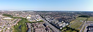
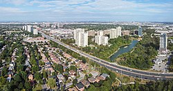
Aerial view of Bramalea in 2021
Coordinates: 43°43′30″N79°43′3″W / 43.72500°N 79.71750°W / 43.72500; -79.71750
CountryFlag of Canada (Pantone).svg  Canada
Province Flag of Ontario.svg  Ontario
Regional municipality Peel
City Brampton
Established1960s as new town
Time zone UTC-5 (EST)
  Summer (DST) UTC-4 (EDT)
Forward sortation area
L6T
Area code(s) 905 and 289
NTS Map030M12
GNBC CodeFALIC
Bramalea Civic Centre building, the former home of the Chinguacousy Township offices, still houses several city services but will vacate as the building will become home to Toronto Metropolitan University's Medical School in 2025. Bramalea Civic Centre - 2021 (cropped).jpg
Bramalea Civic Centre building, the former home of the Chinguacousy Township offices, still houses several city services but will vacate as the building will become home to Toronto Metropolitan University’s Medical School in 2025.
Chinguacousy Park Clock, with the Greenhouse in the background Brampton ON Chinguacousy-Park 2017-10-18 (2).jpg
Chinguacousy Park Clock, with the Greenhouse in the background
Bramalea City Centre BCC Main Entrance 2016.jpg
Bramalea City Centre

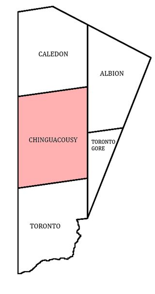
Bramalea (Bram-a-lee) is a large suburban district in the City of Brampton, Ontario, Canada. Bramalea was created as an innovative "new town", and developed as a separate community from the city. Located in the former Chinguacousy Township, it was Canada's first satellite community developed by one of the country's largest real estate developers, Bramalea Consolidated Developments (later Bramalea Limited). [1] [2]

Contents

The name "Bramalea" was created by the farmer William Sheard, who integrated the BRAM from Brampton, MAL from Malton (then a neighbouring town which is now a part of Mississauga), and the LEA, an old British word meaning meadow or grassland. He sold the land to Brampton Leasing developers and built one of Bramalea's first houses on the intersection of Bramalea Road and Avondale Boulevard. Mr. Sheard owned a large parcel of cattle grazing land that was purchased by the new venture.[ citation needed ]

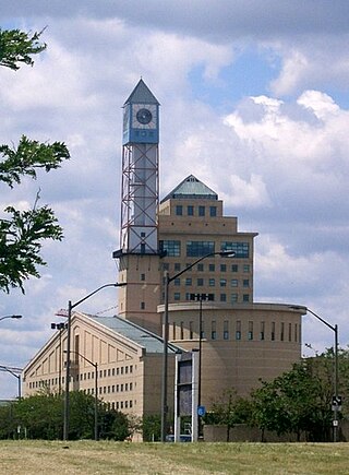
The community had an extensive Master Plan, [3] which included provisions for a parkland trail system of "green belts" that followed small rivulets that feed the Etobicoke Creek and a "downtown", which would include essential services and a shopping centre. The downtown area's centrepiece was the Civic Centre, which included the township's council chamber, a library, live stage theatre, fire dispatch control centre, post office, and the fledgling Rogers Cable community production centre. This building was funded and built by Bramalea's agreement to maintain a particular balance of residential/industrial taxation base. In default, and in lieu of cash payment, Bramalea offered the Civic Centre as recompense. The township accepted.

Shortly thereafter, the Township of Chinguacousy was merged along with the township of Toronto Gore with the Town of Brampton, to become the City of Brampton. Directly across Team Canada Drive from the Civic Centre, Bramalea Limited had built a shopping centre starting in the late 1960s named Bramalea City Centre. The two centrepieces were connected by a short underground passageway under Team Canada Drive, which has long since been sealed due to "hooligan" activities.[ citation needed ] Other features included a police station, which was built before the other structures, (closed in 2008 in order to move into the new Peel Region offices), a bus terminal which was built as a "dial-a-bus" hub, a Holiday Inn (closed and being converted into a senior's residence), and a collection of seniors' retirement homes. Chinguacousy Park was created nearby, to the northeast of Bramalea Road and Queen Street. A ski hill was built up using fill excavated from residential basements.

Each phase of the new city was built with progressing first letters of street names. Development started with the "A" section, with street names like Alderbury, Argyle, Avondale, and Aloma. Then a "B" section was created, "C" section, and so forth. Eventually development reached the M-, N- and P-sections south of Bovaird Drive. Most incorporated local schools, greenspace and pathways. The Zero Lot Line housing concept was pioneered in the G- and H-sections ("The Villages of Central Park"), in an affordable housing joint venture between developers and the Ontario Government called the Home Ownership Made Easy ("HOME") project.

Bramalea is the location of the Brampton Assembly automobile factory, which is now owned by Chrysler but was developed by American Motors for the manufacture of its large Eagle Premier sedan (a joint venture with Renault).

The district is served by the Bramalea GO Station on GO Transit that was located at on Steeles Avenue west of Bramalea Road.

Demographics

By 2013, some groups of people nicknamed Bramalea "Bramladesh" due to the increase of South Asians. [4]

Education

Peel District School Board operates Bramalea Secondary School. [4]

Related Research Articles

<span class="mw-page-title-main">Brampton</span> City in Ontario, Canada

Brampton is a city in the Canadian province of Ontario. It is part of the Greater Toronto Area (GTA) and is a lower-tier municipality within Peel Region. The city has a population of 656,480 as of the 2021 Census, making it the ninth most populous municipality in Canada and the third most populous city in the Greater Golden Horseshoe urban area, behind Toronto and Mississauga.

Visual Arts Brampton is a non-profit community art group located in Brampton, Ontario formed in 1986 to organize the arts community, providing workshops, and exhibits, among other things.

<span class="mw-page-title-main">Caledon, Ontario</span> Town in Ontario, Canada

Caledon is a town in the Regional Municipality of Peel in the Greater Toronto Area of Ontario, Canada. The name comes from a shortened form of Caledonia, the Roman name for what is now Scotland. Caledon is primarily rural with a number of hamlets and small villages, but also contains the larger community of Bolton in its southeastern quadrant, adjacent to York Region. Some spillover urbanization also occurs in the south bordering the City of Brampton.

<span class="mw-page-title-main">Bramalea City Centre</span> Shopping mall in Ontario, Canada

The Bramalea City Centre is a large shopping mall located in the city of Brampton, Ontario, Canada. With over a 1.5 million square feet of retail space and more than 300 outlets, it is one of Canada's largest shopping malls. Regarded as a super regional mall, the Bramalea City Centre has a market of more than 500,000 residents and attracts 16 million visitors annually it was built in 1969. The Bramalea City Centre is located near the intersection of Queen Street and Dixie Road, just east of Highway 410.

<span class="mw-page-title-main">Brampton Centre (federal electoral district)</span> Federal electoral district in Ontario, Canada

Brampton Centre is a federal electoral district in Ontario, Canada, that is represented in the House of Commons of Canada. This riding was created in 1996 from parts of Brampton riding and in 2013, Elections Canada redistributed 3 ridings in the city of Brampton to bring back Brampton Centre. This was primarily due to large population increases in the Greater Toronto Area, and Peel Region in particular.

<span class="mw-page-title-main">Brampton Library</span>

The Brampton Library is a system of public libraries in Brampton, Ontario, Canada.

<span class="mw-page-title-main">Mississauga Civic Centre</span>

The Mississauga Civic Centre is the seat of local government of Mississauga, Ontario, Canada. The 37,280 square metre complex is a prominent example of postmodern architecture in Canada, finished in 1987 by Jones and Kirkland. It stands at 92 metres or 302 feet. The design was influenced by farmsteads which once occupied much of Mississauga as well as historical features of city centres. The building, for instance, includes a prominent clock tower. It was chosen as the winner of a design competition that included 246 submissions. Mississauga Civic Centre is located in the City Centre near Square One Shopping Centre and is home to the Mississauga City Council. The civic center building is considered one of the most iconic and recognizable buildings and cultural icons of Mississauga city.

<span class="mw-page-title-main">Chinguacousy</span>

Chinguacousy Township is a former municipality and present-day geographic township in the Regional Municipality of Peel, Ontario, Canada. In 1974, when Peel County became the Region of Peel, the township was split in half, with the northern half becoming part of the town of Caledon, and the southern half, along with the township of Toronto Gore, joining the Town of Brampton, which was then promoted to a city.

<span class="mw-page-title-main">Toronto Gore</span>

Toronto Gore is a former incorporated and now geographic township in Ontario, Canada. It is today split between Mississauga and Brampton.

<span class="mw-page-title-main">History of Brampton</span>

Following is an outline is for the history of Brampton, the fourth largest city in Ontario, Canada. European settlers arrived began to settle the area in the early 19th century, with Brampton being formally incorporated into a village in 1853.

<span class="mw-page-title-main">Brampton Civic Hospital</span> Hospital in Ontario, Canada

Brampton Civic Hospital is an acute care hospital in Brampton, Ontario and part of the William Osler Health System. It is a community teaching hospital for the Michael G. DeGroote School of Medicine of McMaster University.

<span class="mw-page-title-main">Brampton City Hall</span>

Brampton City Hall is home to Brampton City Council and the departments of the city. It is located at the intersection of Wellington Street and Main Street in downtown Brampton.

<span class="mw-page-title-main">Springdale, Brampton</span> Suburban district in Peel, Ontario, Canada

Springdale is a large suburban district in Brampton, Ontario, Canada covering 4,000 acres (1,600 ha) in the northern part of the city. It is generally bounded by Countryside Drive to the north, Bovaird Drive to the south, Heart Lake Road to the west, and Airport Road to the east. Springdale is sometimes jocularly referred to as Singhdale due to its large population of Sikh Canadians, who make up 39.6% of the community's population and often have the last name Singh.

<span class="mw-page-title-main">Tullamore, Ontario</span> Industrial/Commercial Centre

Tullamore is a semi-rural community on the boundary of Brampton and Caledon, Ontario, Canada. It was named after the town of Tullamore in Ireland. The community is centred on the intersection of Airport Road and Mayfield Road. It had a population of 6 in 2006.

<span class="mw-page-title-main">Bramalea Terminal</span>

Bramalea Terminal is a Brampton Transit bus station serving the community of Bramalea in Brampton, Ontario, Canada. It is located at the south west corner of Peel Centre Drive and Central Park Drive on the north side of the Brampton Civic Centre. The customer service centre building is situated in the northerly of two island platform areas, which are accessed by pedestrian cross walks. Within the building are service counters, washrooms, snack vending machines and a heated waiting area with screens displaying current bus route information.

<span class="mw-page-title-main">Donald M. Gordon Chinguacousy Park</span>

Donald M. Gordon Chinguacousy Park, colloquially known as Chinguacousy Park, is a large 40-hectare (100-acre) park in the Bramalea section of Brampton, Ontario, Canada. It is bounded by Queen Street East on the southeast, Bramalea Road on the northeast, and Central Park Drive on the north and west sides. Terry Fox Stadium (Brampton) in the north of the park, sometimes called Terry Fox Track and Field Stadium, has a track and field oval surrounding an artificial turf field with Canadian Football markings and stands for about 1000 spectators. It is used for various Canadian football and soccer matches as well as track and field competitions.

<i>Kwakiutl</i> (statue) Totem sculpture by Simon Charlie

Kwakiutl is a totem sculpture by Aboriginal Canadian artist Simon Charlie, which has caused controversy for its nudity over multiple decades of display in Chinguacousy Township, and later Brampton, both near Toronto in Ontario, Canada. Charlie, also known as Hwunumetse', later received the Order of Canada. The 9-foot-tall cedar wood sculpture is best known for its exposed male genitals.

Peter Robertson was mayor of Brampton, Ontario from 1991 to 2000. In 2000, he was defeated in the municipal election by then-councillor Susan Fennell.

References

  1. Douglas, Pam (26 April 2018). "THROWBACK THURSDAY: From the ashes of Bramalea Ltd., the Toronto Maple Leafs found a home". The Brampton Guardian. Retrieved 17 January 2024.
  2. "Brampton History". City Of Brampton. Retrieved 17 January 2024.
  3. "Bramalea Blog". 14 December 2013. Retrieved 16 December 2013.
  4. 1 2 Bascaramurty, Dakshana (15 June 2013). "How Brampton demonstrates the new vision of Canada". The Globe and Mail. Archived from the original on 13 May 2016. Retrieved 3 September 2017.

43°43′30″N79°43′3″W / 43.72500°N 79.71750°W / 43.72500; -79.71750